- Seybouse
Infobox_River | river_name = Oued Seybousse

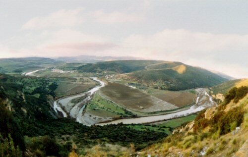
caption = The Seybouse inGuelma Province ,Algeria
origin = Medjez Amar, Algeria
mouth =Mediterranean Sea nearAnnaba , Algeria
basin_countries =Guelma Province andAnnaba Province , Algeria
length = 225 km (140 mi)
elevation =
discharge = 11,5 m³/s (406 ft/s) atGuelma andAnnaba
watershed = 6,471 km² (2,498 mi²)Seybouse is a
oued (river ) in northeasternAlgeria , near the border withTunisia . In Roman times, it was called the "Ubus". The river runs for a distance of about 120 miles. It starts in Medjez Amar, in the north-west ofGuelma Province , and its mouth is at Seybouse (called "Joannonville" under French rule), just to the south-east of the city ofAnnaba (called "Bône" under French rule), the site ofHippo Regius where Saint Augustine lived in AD 391-430. The Seybousse is used for irrigation of agricultural areas, but it is becoming polluted because of industrial activities.Caracteristics
References
* [http://annaba.net.free.fr/html/joannonville.htm The old metal bridge over the river Seybouse at Joannonville]
* [http://www.anrh.dz/ ANRH (National Agency for Water Ressources)]
* [http://cat.inist.fr/?aModele=afficheN&cpsidt=15105543 Potential pollution of groundwater in the valley of the Seybouse River, north-eastern Algeria]
* [http://ccat.sas.upenn.edu/jod/algeria/algeria-sitevisits.html Augustine in Algeria]
* [http://www.1902encyclopedia.com/A/ALG/algeria-03.html 1902 Encyclopedia]
Wikimedia Foundation. 2010.
