- Maunalua Bay
-
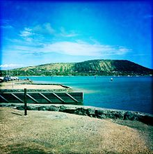 Facing Koko Head
 Facing Diamond Head
Maunalua Bay is a bay on the Southeast shore of the island of Oahu, between Diamond Head and Koko Head, and forming the shoreline of the Hawaii Kai area of Honolulu. "Maunalua" in Hawaiian means two mountains.[1]
History
The beach park was developed by Henry J. Kaiser during the development of Hawaii Kai Marina. Historically, the beach consisted of 535,000 square feet (49,703 sq. m) of coral that was dredged and removed creating a watercraft channel. Kaiser donated it to the City and County of Honolulu in 1960.[1]
Maunalua Bay Beach Park
Public access to the bay is easily made through the city and county beach park off of Kalanianaole Highway across from Hawaii Kai Drive.[2]
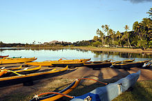
Despite the tide height this bay and reef are always accessible to watercraft, standup paddlers and snorkelers. At low tide people can walk out on the sandbar, exploring the nearby reef. It is not uncommon to find moon jellies that got caught on the sand bar before the tide lowered.
Another scenic spot for tourists near Maunalua Bay, is Hanauma Bay, known for having clear waters and many native fishes, ideal for snorkeling and sightseeing.
References
Coordinates: 21°17′03.18″N 157°43′05.45″W / 21.2842167°N 157.7181806°W
Categories:- Bays of Hawaii
- Landforms of Oahu
- Beaches of Oahu


Wikimedia Foundation. 2010.