- Marland Works railway station
-
Marland Works 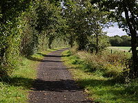
Trackbed of the old line. Location Place Peters Marland Ball clay works Area East Devon Grid reference SS507118 Operations Pre-grouping Torrington and Marland Railway(1881 -1925)
North Devon and Cornwall Junction Light Railway (1925 to 1948)[1]Post-grouping Southern Region of British Railways (1948 to 1966) Platforms One History 27 July 1925 Opened 27 January 1981 Closed Disused railway stations in the United Kingdom Closed railway stations in Britain
A B C D–F G H–J K–L M–O P–R S T–V W–ZMarlands Works was a busy industrial site for just over a century, [2] firstly on the Torrington and Marland Railway[3],built to carry bricks and clay on a three-feet gauge, which in turn was subsumed in 1925 by the North Devon and Cornwall Junction Light Railway[4] before finally becoming part of the Southern Region of British Railways in 1948[5]. The line closed to passenger traffic in 1965[6] as part of the Beeching [7] reforms but the line remained open for freight between Barnstaple railway station and Torrington until 1982[8]. Today it forms part of the popular Tarka trail, although an important site for industrial railway historians[9]too.
References
- ^ Private, not grouped in 1923
- ^ History of Clay web-site Photographer’s research
- ^ North Devon Clay Messenger,M: Truro, Twelveheads Press, 1982 ISBN 0906294061
- ^ Collation of sources, Devon railways
- ^ Branch Lines to Torrington Mitchell,V/Smith,K: Midhurst, Middleton Press,1994 ISBN 1873793375
- ^ "Discovering Britain's lost railways" Atterbury,P: Basingstoke, AA Publishing ISBN 0749563707
- ^ Detailed closure schedules
- ^ Freight details
- ^ IR archives
Preceding station Disused railways Following station Dunsbear
Torrington and Marland Railway (1881-1925)
North Devon and Cornwall Junction Light Railway (1925 to 1948)
Southern Region of British Railways (1948 to 1966)Petrockstow See also
Ex stations on the North Devon and Cornwall Junction Light Railway Torrington • Watergate Halt • Yarde Halt • Dunsbear Halt • Marland Works • Petrockstow • Meeth Halt • Hatherleigh • Hole • Halwill
50°53′20″N 4°7′11″W / 50.88889°N 4.11972°WCoordinates: 50°53′20″N 4°7′11″W / 50.88889°N 4.11972°W
Categories:- Disused railway stations in Devon
- Railway stations opened in 1881
- Railway stations closed in 1966
- South West England railway station stubs

Wikimedia Foundation. 2010.