- Wurzbach Parkway
Infobox TX State Highway
type=
shields=
name=Wurzbach Parkway
maint=TxDOT 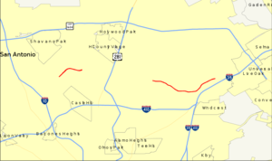
length_mi=
length_round=
length_ref=
formed=
dir1=West
dir2=East
from=Lockhill-Selma Road in San Antonio
junction=
to=O'Connor Road in San AntonioWurzbach Parkway is a part
freeway and part majorarterial road inSan Antonio, Texas built to provide relief on Interstate 410 and Loop 1604 on the city's northside. The highway is named forHarry M. Wurzbach , aU.S. Congressman from San Antonio, whose name was first applied to the connecting Wurzbach Road. The highway is in different stages of completion with the eastern third built as a freeway and the western section as anexpressway with at-grade intersections. Currently there is a gap in the highway, but there are plans to connect the two segments with an interchange with U.S. Highway 281. [Alamo Regional Mobility Authority - [http://www.alamorma.org/WurzbachPkwy.html Wurzbach Parkway Corridor] ] The highway, along with part of Wurzbach Road near theIngram Park Mall , is maintained by theTexas Department of Transportation despite not carrying a state highway designation. Rather, it is being developed and maintained under the Principal Arterial Street System (PASS) program.Texas Department of Transportation - [http://www.dot.state.tx.us/tpp/hwy/pa/pa1502.htm Highway Designation File: Principal Arterial State System No. 1502] ]Texas Department of Transportation , [http://www.dot.state.tx.us/services/transportation_planning_and_programming/glossary.htm Highway Designations Glossary] , accessed September 2007] ] The parkway does not connect to any other freeways, but drivers can access I-10, US 281, and I-35 via local roads that extend the parkway.Route description
The west portion of the parkway is a
limited-access surface road that connects Lockhill-Selma Road with Blanco Road (FM 2696), crossing Military Highway (FM 1535) at-grade. Wurzbach Road continues southwest from Lockhill-Selma Road, crossing I-10 at exit 561. To the east, a second section, built as afreeway , begins at Starcrest Drive (which continues northwest towards US 281) and Wetmore Road, on the northeast side of theSan Antonio International Airport , and heads east beyond Thousand Oaks Drive. At the east end are several at-grade intersections before the parkway ends at O'Connor Road and Crosswinds Way; O'Connor Road leads southeast to I-35 at exit 169.Google Maps street maps and satellite imagery, accessed September 2007]History
Planners conceived the parkway in the mid-1980s as the East-West Parkway, an extension of the existing Wurzbach Road, to relieve traffic on I-410. The road, estimated to cost $90 million, [Dave Pasley,
San Antonio Express-News , [http://www.mysanantonio.com/columnists/stories/MYSA122105.02O.pasleycomment.941b692.html S.A. needs more roads, not toll booths] ,December 21 ,2005 ] was approved by theTexas Transportation Commission in 1988, to be built by the state but funded in part by the city. [Jim Wood,San Antonio Express-News , Wurzbach Parkway work seen in '94 $95 million project to relieve traffic congestion,April 4 ,1993 , p. 1B] Construction began in mid-1994 on the section between Wetmore Road and Nacogdoches Road, [Jim Wood,San Antonio Express-News , State to grant road contract soon - East-West Parkway to extend Starcrest,July 5 ,1994 , p. 9A] and the eastern portion of the roadway opened onAugust 26 ,1999 , allowing traffic to bypass I-410. [Scott Huddleston,San Antonio Express-News , Parkway section to open: Six years, millions needed to complete,August 26 ,1999 , p. 1B] The west section was opened onJuly 24 ,2002 , [Patrick Driscoll,San Antonio Express-News , Wurzbach Parkway's newest stretch opens,July 25 ,2002 , p. 8B] but work has yet to begin on the connection between these two portions.Future
The
Alamo Regional Mobility Authority (RMA) is currently conducting a supplemental environmental assessment on the entire corridor from Lockhill-Selma Road to I-35, emphasizing the segment that has not been constructed. The EA will supplement the EA completed several years ago prior to initial construction. [Alamo Regional Mobility Authority , [http://www.alamorma.org/documents/Wurzbach%20Parkway%20Documents/Community%20Open%20House%20Jan%2025%202007/WurzbachFactSheet_012507.pdf Wurzbach Parkway Project] ] The Alamo RMA is currently considering three alternatives for the interchange with US 281. The first alterative is a Wurzbach Parkway bridge over US 281 with no direct connection between the two highways, but with access via the two highway'sfrontage road s. [Alamo Regional Mobility Authority , [http://www.alamorma.org/documents/Wurzbach%20Parkway%20Documents/Community%20Open%20House%20Jan%2025%202007/Wurzbach%20Bridge%20over%20US%20281.jpgWurzbach Parkway Bridge over US 281 (two levels)] ] The second option includes an elevatedroundabout interchange , that will provide direct access between the highways. [Alamo Regional Mobility Authority , [http://www.alamorma.org/documents/Wurzbach%20Parkway%20Documents/Community%20Open%20House%20Jan%2025%202007/Elevated%20roundabout%20interchange.jpgElevated roundabout interchange (three levels)] ] The final alternative involves main lane to main lane connector ramps from Wurzbach Parkway to US 281 and loop ramps for access from US 281 to Wurzbach Parkway. [Alamo Regional Mobility Authority , [http://www.alamorma.org/documents/Wurzbach%20Parkway%20Documents/Community%20Open%20House%20Jan%2025%202007/Main%20Lane%20to%20Main%20Lane%20Connectors.jpgMain lane to main lane connectors with loop ramps (three levels)] ]Exit list
References

Wikimedia Foundation. 2010.