- Jolo
Infobox Islands
name = Jolo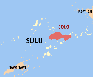
image caption = Map ofSulu showing the location of Jolo
locator
Location map|Philippines|lat=5.983333|long=121.133333|width=175|float=center
map_custom = yes
native name = Sulu
native name link =
location =South East Asia
coordinates=
archipelago =Sulu archipelago
total islands =
major islands = Basilan,Jolo , Mapun (Cagayan de Tawi-Tawi),Tawi-Tawi
area = 869 km²
highest mount =
elevation = 811 m
country = Philippines
country admin divisions title = Municipalities
country admin divisions = Indanan, Jolo, Kalingalan Caluang, Luuk, Maimbung, Old Panamao, Panglima Estino, Parang, Patikul, Talipao
country largest city = Jolo
country largest city population = 87,998
population = 447,700
population as of = 2000
density = 515.6
ethnic groups =Banguingui ,Bajau ,Suluk /TausugJolo is a volcanic island in the southwest
Philippines . It is located in theSulu Archipelago , betweenMindanao andBorneo , and has a population of approximately 300,000 people. Jolo is also the name of the town on the island which serves as the capital of the province ofSulu . About a third of the island's population live in the municipality of Jolo.Fighting on the island intensified in February 2005 when between 4,000 and 5,000 Philippine troops clashed with around 800 Islamist militants from the
Abu Sayyaf group, along with followers ofNur Misuari . Up to 12,000 people were thought to have fled the fighting.The island contains numerous volcanic cones and craters, including the active
Bud Dajo cinder cone.ee also
*
Jolo, Sulu References
*VNUM|1=0700-01=
Wikimedia Foundation. 2010.