- Pambar River
Infobox River
river_name = Pambar River
caption = '
origin =Talaiyar at
coord|10|8|N|77|7|E
mouth =Amaravathi River at
coord|10|21|2|N|77|14|14|E
basin_countries =Idukki District ,Kerala
India
length = ~km to mi|31
elevation = m to ft|2073
mouth_elevation = m to ft|473
discharge =
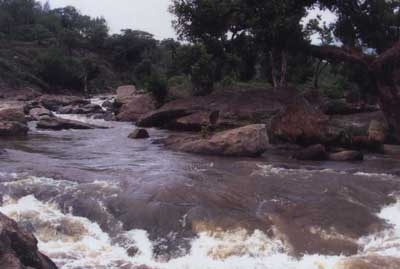
watershed = The Pambar River originates in the Anaimudi Hills inIdukki District ofKerala state inSouth India .Route
It traverses Turner’s Valley in
Eravikulam National Park and flows into theChinnar Wildlife Sanctuary through the Taliar Valley betweenKanthalloor andMarayoor Villages and eastwards through the sanctuary. The Pambar, Kabani and Bhavani are the only rivers of the 44 in Kerala that flow eastwards. It is joined by seasonal rivulets and a few perennial streams originating fromshola s in the upper reaches. [Kerala Forest department, Chinnar Wildlife Sanctuary, Management Plan (2002-2011) [http://chinnar.org/html/managementplan.htm#2 2.5. Water sources] ]The Pambar merges with the
Chinnar River atKoottar where a comfortable tree house accommodation is available. [Blue Yonder Holidays Pvt Ltd, Chinnar, the real treasure trove, retrieved 8/30/2007 [http://www.theblueyonder.com/chinnar.htm#link3 Koottar Tree House] ] The Chinnar follows the interstate boundary along the northwest edge of the sanctuary and becomes theAmaravati River inTamil Nadu , reaches theAmaravathi Reservoir and Dam and eventually joins theKaveri River nearKarur .Waterfalls
Infobox Waterfall
name = Thoovanam Waterfalls
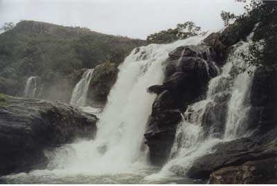
caption = Thoovanam Waterfalls
location =Chinnar Wildlife Sanctuary
latitude = 10.3
longitude = 77.175
elevation = ft to m|num=1400|abbr=no|spell=Commonwealth|precision=2|wiki=yes
type =
height =
height_longest =
average_width =
number_drops =
average_flow =
watercourse =
world_rank =
*The spectacular Thoovanam waterfalls lie on the Pambar River deep within the Sanctuary. This breathtaking cascade is a major tourist attraction. Guided trekking from Karimutti Forest Station can be arranged.
*TheKumbakarai waterfalls are also on the Pambar atKumbakarai village. [National Informatics Centre, Dindigul, TREKKING ROUTES IN Kodaikkanal [http://www.dindigul.tn.nic.in/KodaiTrek.htm 2. Periyakulam – Kumbakarai – Shenbaganur] ] In 2003 a concrete platform would be constructed near the falls, bathrooms exclusively for women would be constructed, a new iron fence would be erected around the falls spot and a parapet wall near the falls site was under construction. [The Hindu (Jun 09, 2003) retrieved 8/30/2007 [http://www.hinduonnet.com/thehindu/2003/06/09/stories/2003060904340500.htm Steps taken for tourists safety at Kumbakarai falls] ]Pambar Shola
The Pambar Shola (elevation 2,000 m.) draining to the Pambar River is now reduced to less than 3 km in circumference. It contains several rare and endemic plant species including:
Sonerila pulneyensis : a delicate succulent herb endemic from Pambar Shola in all of the Palni hills,Hoya wightii ssp. pulneyensis : a succulent vine with waxy flowers endemic to Pambar Shola',Plectranthus bourneate : a succulent herb endemic to Pambar Shola,Trichoglottis tenera : an epiphytic orchid. Pambar Shola is its major habitat,Phyllanthus chandrabosei : a shrub endemic to Pambar Shola,Hupezria sp. : a fern ally endemic to Pambar Shola,Selaginella sp. : a delicate creeping fern endemic to Pambar Shola,Psydrax ficiformis : a tree, until recently thought extinct,Utleria salicifolia : only one clump known on the Palni hills,Elaeocarpus blascoi : a tree believed extinct until this year,Cyathea crinita : tree fern, highly endangered (Botanical Survey of India),Aeschynanthus perrottetii : known only from one other shola in the Palni hills,Eulophia sp. : a new species for the Palni hills first collected in April 2000,Actinodapohne bourneae : Laurel tree believed extinct (Botanical Survey of India). Two trees found in Pambar Shola,Ceropegia thwaitesii : vine, vulnerable, endemic to Pambar shola,Pimpinella pulneyensis : scarce,Exacum anamallayannum :gentian , only one other known location in Palni hills. [Greanpeace India [http://www.greenpeace.org/india/campaigns/toxics-free-future/toxic-hotspots/kodaikanal-tamil-nadu/pambar-shola-a-biodiversity-t Pambar shola: a biodiversity treasure trove under threat] ]References
Wikimedia Foundation. 2010.