- Măgherani
-
Măgherani
Nyárádmagyarós— Commune —  Location of Măgherani
 Location of Măgherani
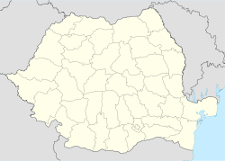
 Măgherani
NyárádmagyarósCoordinates: 46°34′0″N 24°54′0″E / 46.566667°N 24.9°ECoordinates: 46°34′0″N 24°54′0″E / 46.566667°N 24.9°E Country  Romania
County Mureş County Status Commune Government – Mayor Antal Kacsó (Democratic Union of Hungarians in Romania) Population (2002) – Total 2,733 Time zone EET (UTC+2) – Summer (DST) EEST (UTC+3) Măgherani (Hungarian: Nyárádmagyarós or colloquially Magyarós, Hungarian pronunciation: [ˈɲaːraːdmɒɟɒroːʃ]) is a commune in Mureş County, Romania composed of three villages:
- Măgherani
- Şilea Nirajului / Nyárádselye
- Torba / Torboszló
In 2004, Bereni, along with six other villages, broke away from Măgherani to form an independent commune. See Bereni.
Contents
History
It formed part of the Székely Land region of the historical Transylvania province. Until 1918, the village belonged to the Maros-Torda County of the Kingdom of Hungary. After the Treaty of Trianon of 1920, it became part of Romania.
Demographics
The commune has an absolute Székely Hungarian majority. According to the 2002 Census it has a population of 2,733 of which 92.21% or 2,602 are Hungarian.
See also
- List of Hungarian exonyms (Mureş County)
References
Categories:- Communes in Mureș County


Wikimedia Foundation. 2010.