- Neighborhoods of San Antonio
-
The city of San Antonio, Texas is composed of a number of neighborhoods, spreading out surrounding the central downtown area.
Contents
Downtown
Main article: Downtown San AntonioSan Antonio's downtown district, the center point of the city, is a popular destination for tourists, due to attractions such as the Alamo, Riverwalk, Tower of the Americas, and the Rivercenter Mall, which consists of over 100 stores, 21 restaurants, three movie theatres, and the Rivercenter comedy club.
Alamo Heights
Located in the north-central corridor about two miles (3 km) north of downtown and laid out roughly down the north-south axis of Broadway, this area (ZIP Code 78209) is bordered to the south by Mulberry Avenue, to the north by Interstate 410, to the east by Fort Sam Houston, and to the west by US 281. The enclave cities of Alamo Heights and Terrell Hills are included in this area. This area also includes a large swath of Broadway from Mulberry to Loop 410. Inside this area is also Mahncke Park (the neighborhood and the park), the Witte Museum, Brackenridge Park, Botanical Gardens, San Antonio Zoo, San Antonio Country Club and Japanese Tea Gardens. The whole of 78209 zipcode is sometimes referred to as "Alamo Heights" even though the precise boundaries of the Alamo Heights city and school district are much smaller than the boundaries of the zip code.
Midtown
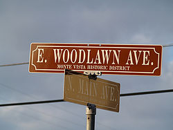

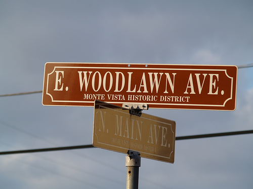
Typical Monte Vista Historic District street sign. Bounded by Hildebrand Avenue to the north, Highway 281 to the east, I-10 to the west and I-35 to the south, Midtown features an assortment of neighborhoods ranging from the working class Beacon Hill to the up-and-coming Five Points to the established upper middle class Monte Vista. Each neighborhood has distinctive housing characteristics, from Victorian in Beacon Hill to French Eclectic, Neoclassical and Italian Renaissance in Monte Vista.
Midtown is one of the most historic areas of metro San Antonio, home to Temple Beth-El, the Pearl Brewery, Trinity University, and neighborhoods such as Five Points, Tobin Hill, Monte Vista Historical District, Alta Vista, Beacon Hill, University Hill, and Trinity Heights.
Olmos Park Terrace, a neighborhood that was granted historic district status by the City of San Antonio in 2007 [1][2], lies just north of Hildebrand next to the City of Olmos Park. It borders the neighborhoods of Midtown, Uptown Broadway, and Downtown.
Uptown Broadway - Uptown Loop
Uptown Central consists of a very large area separated by two segments.
Uptown Broadway is home to a concentrated area of "old money" bedroom communities. These communities are Alamo Heights, Olmos Park, Lincoln Heights, and Terrell Hills. Combined the total population of these three communities is almost 16,000 people on 4.2 square miles (11 km2). That is a density of nearly 4,000 people per square mile (1,500 km²).
Famous people that reside in Uptown Broadway include Thomas Gibson (Terrell Hills), Tommy Lee Jones (Terrell Hills), and many others. This area is home to quite a few high-rise residential buildings, with more planned. Uptown Broadway is also home to many trendy boutiques as well as the University of the Incarnate Word and two very prominent museums, the McNay Art Museum and the Witte Museum.
With nearly five million square feet (465,000 m²) of retail and nearly 20 million square feet (1.86 km²) of office space. Retail in Uptown Loop consists of well known North Star Mall; San Pedro Towne Center, with Best Buy, Barnes & Noble, DSW, and a Toys R Us-Babies R Us combined superstore; Park North Plaza, at the site of what was once Central Park Mall. The new Park North Plaza includes an Alamo Draft House movie theater, Laugh Out Loud Comedy Club, many restaurants, Target, Sears, an Aloft hotel and many more shops. North Star Mall is anchored by Dillard's, Macy's, J.C. Penney, Saks Fifth Avenue, Forever 21 and The Cheesecake Factory.
North Central
North Central is home to many small cities landlocked within the city of San Antonio. Some of these cities are the San Antonio CO-OP district, Castle Hills, Dellview, Hill Country Village, and Hollywood Park. The area also includes the upscale neighborhoods of Elm Creek, Inwood, Rogers Ranch, and Bentley Manor as well as the upper-middle class neighborhoods of Deerfield, Churchill Estates, Hunter's Creek, Oak Meadow, and Summerfield.
Far North Central
Far North Central is home to many of San Antonio's most luxurious homes. Such upscale master-planned communities in this area include Scenic Oaks, Sonterra, Canyon Springs and Stone Oak.
Celebrities in residence include "Stone Cold" Steve Austin, Bruce Bowen, Joe Horn, Eva Longoria, Shawn Michaels, Tony Parker, Tim Duncan and Malik Rose.
Northeast side
The northeast side is home to Randolph Air Force Base, Schertz, Converse, Universal City, Selma, Kirby, Windcrest, and Live Oak. Four school districts educate this side of town, including Judson ISD, Schertz-Cibolo-Universal City ISD and North East ISD. The northeast side also houses The Forum, which is one of San Antonio's largest shopping centers consisting of a variety of shops and restaurants (located on the corner of Loop 1604 and I-35). Rolling Oaks Mall also serves this area (located on the north side of I-35 at Loop 1604 and Nacogdoches Road).
Northwest side
The northwest side of San Antonio is home to a wide range of neighborhoods, suburbs, and businesses unique to the Alamo City.
The community is the location of the main campus of the University of Texas at San Antonio, the University of Texas Health Science Center at San Antonio, and the Northwest Campus of University of the Incarnate Word, which includes the Rosenberg School of Optometry.
Also located in northwest San Antonio is the Medical Center district, which is home to the South Texas Medical Center hospital and research district. The Medical Center is surrounded by neighorhoods including Bluemel, Oak Hills, Mockingbird Hill and Cinnamon Creek. Insurance and banking giant USAA is also headquartered in the area.
The corporate headquarters of Valero; Security Service Federal Credit Union; NuStar Energy; and Kinetic Concepts are all located in the area, mainly along the I-10 corridor. The area is also home to Six Flags Fiesta Texas; the upscale open air shopping center The Shops at La Cantera, anchored by Dillard's, Macy's, Neiman Marcus and Nordstrom; and the 2,000,000-square-foot (190,000 m2) suburban retail center The Rim, anchored by Bass Pro Shops' Outdoor World, and The Palladium, a 19-screen movie theater featuring IMAX screens. This area also includes prestigious neighborhood The Dominion, which is home to David Robinson, many current San Antonio Spurs players and coaches, and George Strait. The wealthy city of Shavano Park is also on the Northwest Side, as is Camp Bullis. Eastward view of the South Texas Medical Center, some 11 miles (18 km) northwest of downtown San Antonio
Far West side
This is one of the fastest growing areas in Metropolitan San Antonio. A large part of this area is outside of the San Antonio city limits, but is served by Bexar County Government. Here you will find Sea World Texas, Northwest Vista College, QVC, Wachovia, CitiCorp and several other large employers. The Far West subdivisions attract many military families who relocate from all over the US due to its close proximity to Lackland AFB. With new homes starting in the low to mid 100's, the area attracts many middle-class families and first time home buyers. Major roads include Loop 1604, State Highway 151, U.S. Highway 90, and Loop 410. Due to the recent real estate boom in the area, Christus Santa Rosa Westover Hills Hospital, numerous businesses including Kohl's, HEB Plus, and Super Wal-mart have moved in as well as many restaurant chains and other specialty stores to the new master planned community of Alamo Ranch.
West side
Known for its Mexican and Tejano culture, which is showcased in places like the Guadalupe Street commercial and entertainment district and the Basilica of the National Shrine of the Little Flower, the West side is also home to the historic Our Lady of the Lake University, and St. Mary's University. The west side is a predominantly Hispanic neighborhood.
The West side's historic Prospect Hill neighborhood, one of the first communities to be built in this area, is rich in history and is within the original 36 miles of downtown San Antonio. Notable Prospect Hill residents (past and present) include former San Antonio Mayor / 10th US HUD Secretary Henry Cisneros, actress Carol Burnett, and Congressman Henry B. Gonzalez. The housing is primarily modest 2- and 3-bedroom homes with a mix of early 1900s and post-WWII houses.
South Side
This area is located south of Downtown. The South Side is characterized as a predominantly Hispanic neighborhoods, upwards of about 85 to 97 percent. South of Cesar Chavez along South Presa/South Saint Mary's/South Alamo streets and, more recently, South Flores is an area known as Southtown. Southtown includes the King William Historic District and the Lavaca neighborhood, as well as the warehouse and loft conversions of Blue Star Contemporary Art Center along South Flores/Probandt/Cevallos streets. Once labeled Texas' most eccentric neighborhood by Texas Monthly magazine, Southtown is known for its diverse community, art galleries, restaurants, and Victorian era homes. There is a heavy concentration of resident artists and contemporary art spaces, such as those found on emerging South Flores. Restaurants and bars in Southtown include Bar America, Blue Star Brewing Company (adjacent to Blue Star Contemporary Art Center), Rosario's, La Tuna, El Mirador, The Friendly Spot, and The Monterey. Art spaces and galleries include Blue Star Contemporary Art Center, UTSA Satellite Space, San Antonio Art League, SAY Si!, Joan Grona Gallery, David Shelton Gallery, Cactus Bra Space, Three Walls Gallery, Justice Works, REM Gallery, San Angel Folk Art, Stone Metal Press, and Fiber Artspace. On the first Thursday of the month the serious area art galleries have openings. On the first Friday of every month, Blue Star essentially acts as the hub of the downtown event known as First Friday. A diverse crowd of art lovers can visit galleries, art spaces, vintage stores, and street vendors selling art and jewelry, all while listening to live music. Second Saturday is usually on the following weekend after First Friday but sometimes falls on the very next day. Second Saturday is a monthly showcase of the area commonly known as SoFlo (a trendy abbreviation for the South Flores street where it is located) also known by its inhabitants as the South Flores Arts District. The area is only a few blocks South of the Blue Star District but is popular for those who want a less crowded environment than the one found at First Friday. Art galleries include One9Zero6, FL!GHT, LoneStar Studios, Salon Mijangos, Gallista Gallery, and Triangle Project Space. Artists in the area with studios include Andy Benavides, Justin Parr, Ed Saavedra, Zane Lewis, Thomas Cummins, and Dario Robleto. Once a year in the Fall, the S.M.A.R.T fair is an annual festival held to support the various arts in San Antonio.[3][dead link] Also on the south side of town is Texas State Highway Loop 13 more commonly known as Military Drive. Loop 13 served as the cities primary loop before Interstate 410 was constructed. Millitary Drive links many of the cities millitary facilities on the southern part of town such as Lackland Air Force Base, Kelly Field Annex the former Kelly Air Force Base, Stinson Municipal Airport, and Brooks City-Base formally Brooks Air Force Base before turning into W.W. White Rd. which heads north becoming Farm to Market Road 78 leading to Randolph Air Force Base in Universal City, Texas. A huge growth in the south side came when Toyota decided to build a manufacturing plant that produces the Toyota Tundra and more recently Toyota Tacoma pick-up trucks, near Texas State Highway 16 and Interstate 410 interchange. Most of the south side's shopping centers are located on Military Drive near major intersections. Interstate 35 & Southwest Military Drive, South Park Mall which is anchored by such stores such as Macy's,Sears,Bealls (Texas) and J.C. Penny. Along the intersection of Interstate 37 & South New Braunfels, The McCreless Market Shopping Center formally McCreless Mall which is an open air shopping center anchored by H-E-B Plus!, Bealls (Texas), and a 16 screen Cinemark Theaters. And the Southeast Military Drive and IH-37 corridor is home to City-Base Landing that has such stores as Super Wal-Mart, H-E-B, Target, and Best Buy. City-Base landing West is also the home of a brand new state of the art Mission Trail Baptist Hospital that opened in 2011, the first new hospital on the south side in nearly forty years. Another new addition is the Brand New Mission Branch Library on Roosevelt Avenue near the San Jose Mission. This library was built on the site of the old Mission Drive-In which was the last drive-in theater in the city for many years. The drive-in was recently remodeled until it was vandalized and was deemed too expensive to reopen. A single theater is still preserved in it's memory. The South Side is also home to Palo Alto College and the newly opened Texas A&M University-San Antonio. Before the beginning of this decade many of the cities young population would cruise "Military". Many classic cars and lowriders would drive close to the 35 intersection and muscle cars and import street racers would hang out close to the 37 intersection along the main entrance of what was once the main gate of Brooks A.F.B. The south side is predominantly Hispanic especially in it's inner city neighborhoods such as Harlandale, Palm Heights, Columbia Heights, Hot Wells, Highland Hills, Indian Creek, Valley Hi, and Palo Alto. Four out of five of the cities historic missions are located on the south side along the San Antonio River besides the Alamo or Mission San Antonio de Valero. Mission San Jose (Texas), Mission Concepcion, Mission San Juan Capistrano, and Mission San Francisco de la Espada. The San Antonio River Walk is also extending into the south side and can now be seen all the way into Concepcion Park and is continuing to grow further outwards towards Military Drive. San Antonio's famous "Ghost Tracks" is located in the cities McCreless Meadows neighborhood near the intersection of Villaman Rd. and Shane. An old tale that a school bus was in an accident many years ago and a group of children were supposedly all killed. A phenomenon is supposed to happen when your vehicle is put in neutral with the ignition off, the vehicle begins to roll up hill crossing the tracks all on its own. It is said that the children's ghost are pushing your vehicle out of the way of a passing train. Many people put talcum powder all over their vehicle and fingerprints will begin to show up after the tracks are crossed. All the streets located in the neighboring neighborhood are named after what is supposedly named after all of the children that were killed there long ago. The southern part of the city does not extend as far outward towards Texas State Highway Loop 1604 like much of the far northern parts if the city do. Much of the city outside loop 410 remains unincorporated and rural. the suburb of Elmendorf, Texas sits along south side's two main lakes, Victor Braunig Lake and Calaveras Lake (Texas).
East Side
Home to Saint Paul Square, the Alamodome, San Antonio Stock Show & Rodeo, the AT&T Center and its older neighbor, the Freeman Coliseum. Other northern cities include Windcrest, a northeastern suburb known for its extravagant Christmas light displays. The southeastern suburb of China Grove is located along US 87 and was the subject of a Doobie Brothers song entitled China Grove. The East Side is predominantly[citation needed] an African-American neighborhood. The East Side most notable residents were actress Joan Crawford and congressman Percy Sutton of New York. Joan Crawford was born and raised on the infamous Cherry Street area. Soap star Al Freeman was also born and raised in San Antonio along with actress Paula Pentriss.
See also
- Carl Wilhelm August Groos House
References
- ^ http://www.sanantonio.gov/clerk/Minutes/2007/20071004.pdf
- ^ http://www.olmosparkterrace.org
- ^ South Flores Arts District upbeat, lively, San Antonio Express News, January 25, 2008.
External links
- Office of Cultural Affairs, City of San Antonio
- List of San Antonio Neighborhood Associations
- San Antonio Neighborhood Profiles and Information
- Olmos Park Terrace Neighborhood and Historic District Website
Municipalities and communities of Bexar County, Texas Cities Alamo Heights | Balcones Heights | Castle Hills | Cibolo‡ | Converse | Elmendorf | Fair Oaks Ranch‡ | Grey Forest | Helotes | Hill Country Village | Kirby | Leon Valley | Live Oak | Lytle‡ | Olmos Park | San Antonio‡ | Schertz‡ | Selma‡ | Shavano Park | Somerset | Terrell Hills | Universal City‡ | Von Ormy | Windcrest
Towns CDPs Unincorporated
communitiesFootnotes ‡This populated place also has portions in an adjacent county or counties
Categories:- Neighborhoods in San Antonio, Texas
- Lists of neighborhoods in U.S. cities


Wikimedia Foundation. 2010.