- Burco
Infobox Settlement
official_name = Burco
other_name =
native_name =
nickname =
settlement_type =
motto =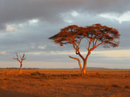
imagesize = 300px
image_caption = The Burao countryside enroute toBerbera
flag_size =
image_
seal_size =
image_shield =
shield_size =
image_blank_emblem =
blank_emblem_type =
blank_emblem_size =
mapsize =
map_caption =
mapsize1 =
map_caption1 =
image_dot_
dot_mapsize =
dot_map_caption =
dot_x = |dot_y =
pushpin_
pushpin_mapsize =300
pushpin_label_position =bottom
pushpin_map_caption =Location in Somalia
subdivision_type = Country
subdivision_name = flag|Somalia
subdivision_type1 = Region
subdivision_name1 =Togdheer
subdivision_type2 = District
subdivision_name2 =
subdivision_type3 =
subdivision_name3 =
subdivision_type4 =
subdivision_name4 =
government_footnotes =
government_type =
leader_title =
leader_name =
leader_title1 =
leader_name1 =
leader_title2 =
leader_name2 =
leader_title3 =
leader_name3 =
leader_title4 =
leader_name4 =
established_title =
established_date =
established_title2 =
established_date2 =
established_title3 =
established_date3 =
area_magnitude =
unit_pref =Imperial
area_footnotes =
area_total_km2 =
area_land_km2 =
area_water_km2 =
area_total_sq_mi =
area_land_sq_mi =
area_water_sq_mi =
area_water_percent =
area_urban_km2 =
area_urban_sq_mi =
area_metro_km2 =
area_metro_sq_mi =
area_blank1_title =
area_blank1_km2 =
area_blank1_sq_mi =
population_as_of =
population_footnotes =
population_note =
population_total =
population_density_km2 =
population_density_sq_mi =
population_metro =
population_density_metro_km2 =
population_density_metro_sq_mi =
population_urban =
population_density_urban_km2 =
population_density_urban_sq_mi =
population_blank1_title =Languages
population_blank1 =Somali, Arabic, and English
population_blank2_title =Religions
population_blank2 =Sunni Islam
population_density_blank1_km2 =
population_density_blank1_sq_mi =
latd=9|latm=31|lats= |latNS=N
longd=45 |longm=32|longs= |longEW=E
timezone =East Africa Time
utc_offset = +3
timezone_DST =
utc_offset_DST =
elevation_footnotes =
elevation_m =
elevation_ft =
postal_code_type =
postal_code =
area_code =
blank_name =
blank_info =
blank1_name =
blank1_info =
website =
footnotes =Burao ( _so. Burco) is the capital city of the
Togdheer province ofSomalia . In terms of population, it is the second largest city in northwestern Somalia afterHargeisa .History
Burco was the site of the unilateral and internationally unrecognized declaration of an independent
Somaliland in June 1991. [cite web|url=http://www.world66.com/africa/somaliland/history|title=Somaliland History|accessdate=2007-07-17|format=HTML|work=World66 |publisher=Internet Brands|quote=In 1991, after the collapse of the government in Somalia, the territory asserted its independence as the Republic of Somaliland, at a meeting of clan elders in the town of Burao.] Also like the other cities in the northern part of the country, Burao has been rebuilt with limited outside aid. The city has boomed economically with the money coming in and people from rural areas moving to the city.Population
Burao's population has more than tripled since 1991, to around 100,000. Today the city has a population more than 400,000.Fact|date=July 2007 Although information on the number of people voting in the city in 2006 parliamentary elections is available, no census was conducted for more than 20 years.
The city also full-time
electricity and a reliablewater supply fromgroundwater . Burao's central location has also contributed to the economic revival of the city. Goods travelling to the south, central and eastern Somalia all depart from the outerskirts of the city. Rural merchants also sell their produce in a daily basis which brings the city business,culture and nomadic spirit.Geography
Weather in Burao, much like other inland towns in northern Somalia, is warm and dry year round. The average daytime temperatures during the summer months of June-August can rise to 35°C (95°F), with low of 25°C (77°F) at night. The weather is cooler the rest of the year and is 27°C (80°F) during the day and 14°C (57°F) at night time. The city's limited rainfall usually comes in December and May.
The
Togdheer River runs through the town. The river is often dry but subject to flooding, when it divides the city in half and can be crossed by a newly built bridge at the city centre.WildlifeDue to the fertility and greenery of the Hargeisa region, wild animals (e.g. zebras) come to the area; to either breed or graze on the grassland savannah. There are many animals which can be found in Hargeisa. The prominent animals found are the Kudu, wild boar, Somali Wild Ass, warthogs, antelopes, the Somali sheep, wild goats, camels and many different types of birds. Due south of burao is a grassland savannah which attracts many types of wildlife to the area including lions and leopards.Transport
Burao has a working bus system and there is the Burao airport nearby which has flights with
Daallo Airlines toHargeisa ,Addis Ababa ,San'a and other cities inSomalia . An all weather road connects Burco to the port ofBerbera via the escarpment town ofSheikh .ee also
*
Dul Madoba References

Wikimedia Foundation. 2010.