- Rosewood, Saskatoon
Infobox Settlement
official_name = Rosewood
other_name =
native_name =
nickname =
settlement_type = Neighborhood
motto =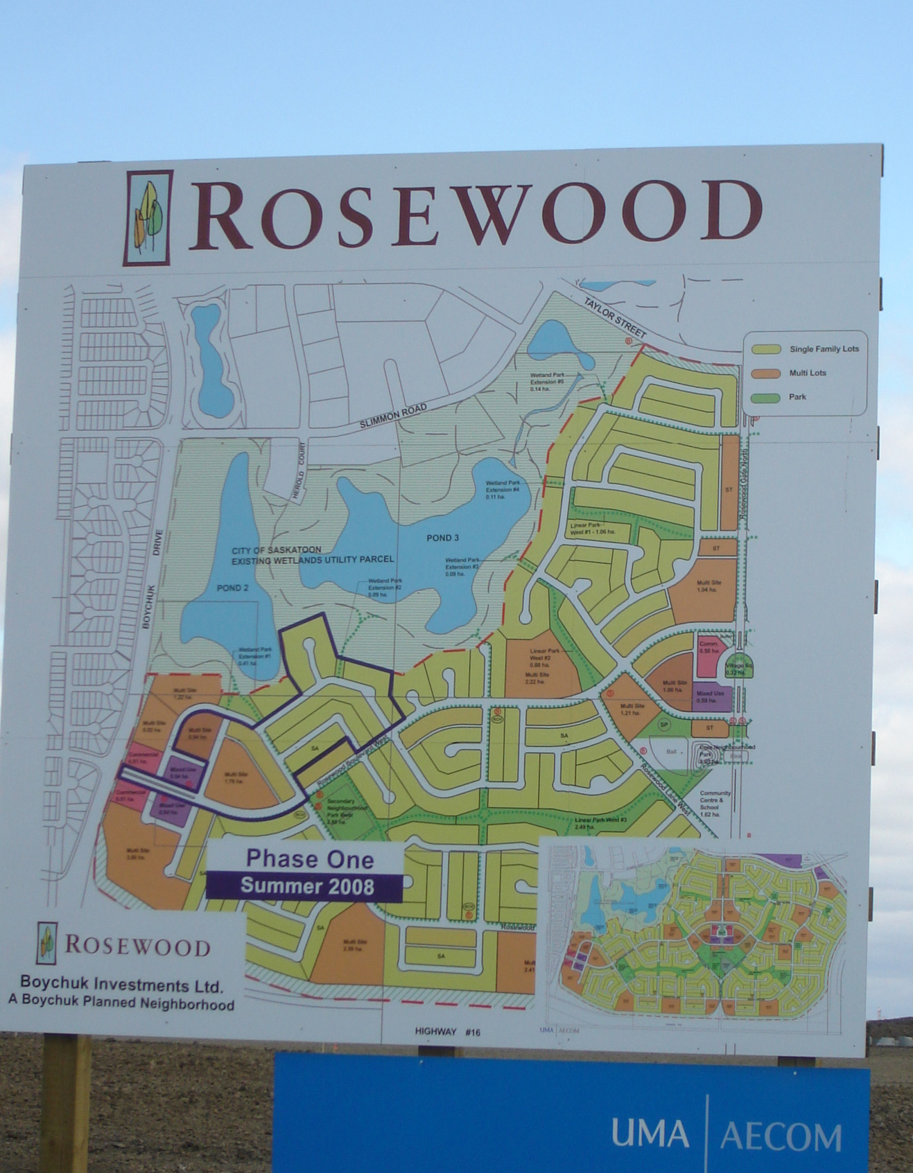
imagesize =
image_caption = Rosewood community plan
flag_size =
image_
seal_size =
image_shield =
shield_size =
city_logo =
citylogo_size =
mapsize =
map_caption = Rosewood location map
mapsize1 =
map_caption1 =
image_dot_
dot_mapsize =
dot_map_caption =
dot_x = |dot_y =
pushpin_
pushpin_label_position =
pushpin_map_caption =
pushpin_mapsize =
subdivision_type = Country
subdivision_name = CAN
subdivision_type1 = Province
subdivision_name1 = SK
subdivision_type2 = City
subdivision_name2 = Saskatoon
subdivision_type3 = Suburban Development Area
subdivision_name3 = Lakewood
subdivision_type4 = Neighbourhood
subdivision_name4 = Rosewood
government_footnotes =
government_type = Municipal (Ward 9)
leader_title = Administrative body
leader_name =Saskatoon City Council
leader_title1 = Councillor
leader_name1 = Tiffany Paulsen
leader_title2 =
leader_name2 =
leader_title3 =
leader_name3 =
leader_title4 =
leader_name4 =
established_title = Annexed
established_date = 1980-1984
established_title2 = Construction
established_date2 = TBA
established_title3 =
established_date3 =
area_magnitude =
unit_pref =
area_footnotes =
area_total_km2 = 1.61
area_land_km2 =
area_water_km2 =
area_total_sq_mi =
area_land_sq_mi =
area_water_sq_mi =
area_water_percent =
area_urban_km2 =
area_urban_sq_mi =
area_metro_km2 =
area_metro_sq_mi =
population_as_of = 2008
population_footnotes =
population_note =
population_total = 11,000 (proposed est.)
population_density_km2 =
population_density_sq_mi =
population_metro =
population_density_metro_km2 =
population_density_metro_sq_mi =
population_urban =
population_density_urban_km2 =
population_density_urban_sq_mi =
population_blank1_title = Average Income
population_blank1 = $
population_density_blank1_km2 =
population_density_blank1_sq_mi =
timezone = UTC
utc_offset = -6
timezone_DST =
utc_offset_DST =
latd=52 |latm= 5|lats=38 |latNS=N
longd= 106|longm= 32|longs= 42|longEW=W
elevation_footnotes =
elevation_m =
elevation_ft =
postal_code_type =
postal_code =
area_code =
blank_name =
blank_info =
blank1_name =
blank1_info =
website =
footnotes = City of Saskatoon NeighborhoodsRosewood is a neighbourhood that is currently under construction, and located in southeast
Saskatoon ,Saskatchewan ,Canada . The southwest corner of the community will consist of a commercial hub and multi-family dwellings, while a village square with businesses, parks and multi-family dwellings is planned for the center of the neighbourhood.cite web
last =
first =
authorlink =
coauthors =
title = Rosewood Concept - Sept 28 2007
work =
publisher = City of Saskatoon
date = 2007
url = http://www.saskatoon.ca/org/land/residential/land_for_sale/Rosewood%20Concept%20-%20Sept%2028%202007%20Layout1%20(1).pdf
format =
doi =
accessdate = 2008-03-31] Housing will consist of approximately 2750 single-unit dwellings, 1350 low density townhouse units, and 175 medium density apartment style units.cite web
last =
first =
authorlink =
coauthors =
title = Rosewood Neighbourhood
work =
publisher = City of Saskatoon
date = 2007
url = http://www.saskatoon.ca/org/development/services/procedures/rosewood_open_house.asp
format =
doi =
accessdate = 2008-03-31] Between 2022 and 2025, Rosewood will reach completion and have an estimated population of 11,000. [cite news
last = Steuart
first = Tim
coauthors = Shall Lam, Katherine Whiting
title = Open House Rosewood Neighbouhood Open House
work =
pages = 21
language = English
publisher = Saskatoon Sun
date = 2007-06-17
url =
accessdate = 2007-06-19 ]History
The land where Rosewood is planned to exist was annexed between 1980 and 1984.cite web
last =
first =
authorlink =
coauthors =
title = Populace Spring 2006
work =
publisher = City of Saskatoon
date = 2006
url = http://www.saskatoon.ca/org/city_planning/resources/populace_newsletter/Populace_Spring_2006.pdf
format =
doi =
accessdate = 2008-03-31] Servicing of the land began in 2008.The City of Saskatoon has yet to announce the theme for naming of streets in Rosewood. The concept plan shows several major access streets labelled Rosewood, suggesting the communtiy may follow the same naming pattern used by Stonebridge, Willowgrove and Hampton Village in assigning the community name to major access routes and using other names for the side streets.
Government and politics
When completed, Rosewood will exist within the federal electoral district of
Saskatoon—Humboldt . It is currently represented byBrad Trost of theConservative Party of Canada , first elected in 2004 and re-elected in 2006.Provincially, the area is within the constituency of
Saskatoon Southeast . It is currently represented byDon Morgan of theSaskatchewan Party , first elected in 2003 and re-elected in 2007.In Saskatoon's non-partisan municipal politics, Rosewood will lie within ward 9. It is currently represented by Councillor
Tiffany Paulsen , first elected in 2000 and re-elected in 2003 and 2006.Institutions
Education
The current proposal shows land allocated for two schools at the center of the neighbourhood. To date, there have been no announcements from either the public or separate boards about future schools in Rosewood.
Parks and recreation
The current drawings show a core neighbourhood park at the center of the neighbourhood adjacent to the school and mixed-use "village square" sites.
Linear park s link to two neighbourhood parks closer to the east and west peripheries, and two small "pocket" parks in the northeast part of the neighbourhood.Commercial
The plans for Rosewood show two dedicated commercial zones: one at the southwest entrance to the neighbourhood, and the other surrounding the village square. Another mixed-use site in the northeast is another possible location for businesses. Rosewood is located adjacent to the Lakewood Suburban Centre which already has established commercial development.
Location
Rosewood is located within the Lakewood Suburban Development Area. It is bounded by the
Canadian Pacific Railway tracks and a future highway right-of-way to the east, Highway 16 to the south, Boychuk Drive to the west, and Taylor Street to the north. Inside those boundaries, the roads are a mix of local andcollector road s.The current proposal shows that Rosewood will have access points on all four sides of the community, including an access to Highway 16 to the south and the proposed Perimeter Highway to the east. There will be two access roads off Taylor Street, plus one off Boychuk Drive which will double as an eastern extension of Kingsmere Boulevard.
Geographic Location (8-way)
Centre = Rosewood
North = Briarwood
Northeast = R.M. of Corman Park
East = R.M. of Corman Park
Southeast = R.M. of Corman Park
South = R.M. of Corman Park
Southwest = R.M. of Corman Park
West = Lakeridge
Northwest = Lakewood Suburban Centre

References
External links
* [http://www.saskatoon.ca/org/development/services/procedures/rosewood_open_house.asp Rosewood Neighbourhood]
* [http://www.saskatoon.ca/org/land/residential/land_for_sale/Rosewood%20Concept%20-%20Sept%2028%202007%20Layout1%20(1).pdf Rosewood Concept - Sept 28 2007]
* [http://www.saskatoon.ca/org/city_planning/zam_maps/index.asp City of Saskatoon City of Saskatoon · Departments · Community Services · City Planning · ZAM Maps]
* [http://www.saskatoon.ca/org/city_planning/resources/populace_newsletter/Populace_Spring_2006.pdf Populace Spring 2006]
Wikimedia Foundation. 2010.