- Odendorf
-
Map 
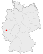
Odendorf is a village in Germany, belongs to the municipality of Swisttal, County of Rhein-Sieg in North-Rhine-Westphalia. The Village is situated approx. 20 km southwest of Bonn. In 2007 it had 3581 inhabitants.[1].
Contents
Local Business
Odendorf offers a wide range of local Business. Situated in the Village are an Edeka Supermarket, also an Aldi as well an Schlecker Drugstore. Also an Gas-Station, Post Office, Banks, Pharmacy and several Restaurants are based in the Village. In a new business park further industrial business (manufacturing, wholesale trade) is located and land is still available for sale.
Infrastructure
Odendorf is located 6km west of Highway A61 with connection to Aachen (A61), Cologne (A1) and Koblenz (A61). Also Deutsche Bahn offers an regular Train Service between Euskirchen and Bonn. Also a Bus Service to Rheinbach and Euskirchen (School-Service only) is available. The nearest Airport is Cologne/Bonn Airport.
People
- Pius Heinz - Winner of the Main Event at the 2011 World Series of Poker[2].
References
- ^ References: Website der Gemeinde Swisttal
- ^ "PIUS HEINZ WINS 2011 WSOP MAIN EVENT CHAMPIONSHIP". WSOP. November 8, 2011. http://www.wsop.com/news/2011/Nov/3605/PIUS-HEINZ-WINS-2011-WSOP-MAIN-EVENT-CHAMPIONSHIP.html. Retrieved November 9, 2011.
External links
Categories:- Towns in North Rhine-Westphalia
- North Rhine-Westphalia geography stubs
Wikimedia Foundation. 2010.
