- Valley of Oaxaca
-
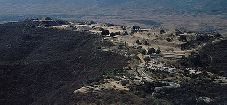 Looking southwest over the site of Monte Alban. Situated on a mountaintop, Monte Alban overlooks much of the Valley of Oaxaca.
The Valley of Oaxaca is a geographic region located within the modern day State of Oaxaca in southern Mexico. The valley, which is located within the Sierra Madre Mountains, is shaped like a distorted and almost upside-down “Y,” with each of its arms bearing specific names: the northwestern Etla arm, the central southern Valle Grande, and the Tlacolula arm to the east. The Valley of Oaxaca was home to the Zapotec civilization, one of the earliest complex societies in Mesoamerica, and the later Mixtec culture. A number of important and well-known archaeological sites are found in the Valley of Oaxaca, including Monte Alban, Mitla, San José Mogote and Yagul. Today, the capital of the state, Oaxaca City, is located in the central portion of the valley.
Contents
History
The Zapotec dominated the valley and much of the Oaxacan highlands from the Early Formative through the end of the Classic period. They were succeeded by the Mixtec culture during the Postclassic period.
Formative period
One of the earliest settlements in the Valley of Oaxaca was San José Mogote, located in the northwestern part of the Etla arm. Initially a permanent agricultural village during the Early Formative, it eventually developed social stratification where elite social positions were ascribed, i.e., sociopolitical prominence was achieved at birth, rather than earned.
It is clear that the Formative inhabitants of the valley interacted with the socially complex Olmec culture of the Olmec heartland. It is unclear, however, what effect these interactions had on the development of Zapotec civilization. The Olmec influences on Mesoamerican culture is still under debate.
While San José Mogote functioned as a small center in the northwestern arm of the valley, a number of other contemporaneous centers existed in the Valley of Oaxaca. These were Tilcajete in the Valle Grande and Yegüih in the Tlacolula arm. Through the end of the Middle Formative, population in the valley was dispersed and centered around these three separate settlements. Interaction between the three settlement systems was likely high, as a general homogeny of ceramic styles and iconography is eveident.
Substantial cultural changes become evident during the Late Formative, including a dramatic population shift and the political centralization of the valley under the previously uninhabited capital of Monte Alban. There is no evidence that Monte Alban existed as of 600 BC, but by 400 BC the site, which is located atop a 400 m tall artificially-leveled mountain and completely lacking in easily-accessible water sources, had a population of ca. 5,200. Within 200 years, the settlement’s population had grown to approximately 17,200, quickly making it one of the most populous Mesoamerican cities at the time. This inordinate population growth occurred simultaneously with the rapid abandonment of the other major centers occupying the three arms of the Valley of Oaxaca (San José Mogote, Tilcajete, and Yegüih). The rapid shift in population and settlement, from dispersed localized centers to a concentration in a previously unsettled area, has been referred to as the “Monte Alban Synoikism” by Marcus and Flannery.[1]
Throughout the remainder of the Late Formative, Monte Alban became the central point of political power and administrative activities in the Valley of Oaxaca, forming a state-level society. This Zapotec state subsequently expanded into the Oaxacan highland areas outside of the Valley of Oaxaca and towards the Pacific lowlands to the south. As such, it became a prominent regional polity in Mesoamerica.
Classic period
Throughout the Early Classic period (AD 200-650), Monte Alban and, by extension, the Valley of Oaxaca formed the nucleus of the Zapotec polity. Interaction with other Classic period polities, specifically Teotihuacan, is evident. Monuments and murals at Monte Alban depict the arrival of visitors from Teotihuacan,[2] while there is evidence that a Zapotec “barrio” existed at the central Mexican city.[3]
Monte Alban’s prominence lasted through to the end of the Early Classic. Perhaps too reliant on Teotihuacan, the decline of Monte Alban’s influence appears to correlate with the collapse of the Teotihuacan polity. During this time other centers, once subjects of Monte Alban and incorporated within the Zapotec state, began to assert their own autonomy. These include Cuilpan and Zaachila in the Valle Grande and Lambityeco and Mitla in the eastern Tlacolula arm. By the time of the Terminal Classic (ca. AD 900), it is clear that the former capital had been abandoned.[4]
Postclassic period
During the Postclassic period (roughly AD 1000-1520), the Valley of Oaxaca was still occupied by Zapotec people, but often fell under the political provenience of the Mixtec state, located to the west of the valley. One prominent Mixtec center is found at Mitla, located in the eastern Tlacolula arm. Shortly following the Aztec defeat of the Mixtec, the Zapotec were likewise conquered by the Aztec under the emperor Ahuitzotl, between 1497 and 1502. The Valley of Oaxaca was subsequently subsumed within the Aztec Empire.
Colonial period
The Aztec empire collapsed when their capital, Tenochtitlan, fell to the Spanish in August of 1521. Several months later, on November 25, 1521, Francisco de Oruzco arrived in the Valley of Oaxaca to claim it in the name of the conquistador Hernán Cortés. Cortés, who had been granted Oaxaca as his prize for conquering New Spain by the Spanish crown, was thereafter named Marques del Valle de Oaxaca.
In 1521, the Spanish settled in a community known as Segura de la Frontera, located in the central part of the Valley of Oaxaca and approximately 9 km (5.6 mi) east of Monte Alban. Later known as Nueva Antequera, it was officially raised to the category of a "royal" city in 1532 by decree of Emperor Charles V (Carlos I) with the name of Antequera de Guaxaca. Today it is known simply as Oaxaca or Oaxaca City. Following the initial settlement of this community, the Spanish quickly introduced new agricultural crops and methods of cultivation into the Valley of Oaxaca. For example, Cortés ordered the cultivation of wheat in the Etla arm and the construction of mills.
Notes
- ^ Marcus and Flannery (1996:140-146); Synoikism refers to the dramatic settlement of a new community that was previously non-existent and that incorporates communities that were separate or independent prior to the site's formation. As Marcus and Flannery mention, it is applied to the eventual formation of Sparta.
- ^ Marcus 1983.
- ^ Paddock 1983.
- ^ Blanton, et al. (1999)
See Also
References
-
- Blanton, Richard E.; Gary M. Feinman, Stephen A. Kowalewski, and Linda M. Nicholas (1999). Ancient Oaxaca: the Monte Albán State. London: Cambridge University Press. ISBN 0-521-57787-X. OCLC 41420906.
- Joyce, Arthur A. (2010). Mixtecs, Zapotecs and Chatinos: Ancient peoples of Southern Mexico. Wiley Blackwell. ISBN 978-0-6312-0977-5.
- Marcus, Joyce (1983). "Teotihuacan Visitors on Monte Alban Monuments and Murals". In Kent V. Flannery and Joyce Marcus (eds.). The Cloud People: Divergent Evolution of the Zapotec and Mixtec Civilizations. New York: Academic Press. pp. 175–181. ISBN 0-122-59860-1. OCLC 8805988.
- Marcus, Joyce; and Kent V. Flannery (1996). Zapotec Civilization: How Urban Society Evolved in Mexico's Oaxaca Valley. London: Thames & Hudson. ISBN 0-500-05078-3. OCLC 34409496.
- Paddock, John (1983). "The Oaxaca Barrio at Teotihuacan". In Kent V. Flannery and Joyce Marcus (eds.). The Cloud People: Divergent Evolution of the Zapotec and Mixtec Civilizations. New York: Academic Press. pp. 170–175. ISBN 0-122-59860-1. OCLC 8805988.
State capital Governor Gabino Cué MonteagudoMajor topics History -Economy - DemographicsMajor communities Huajuapan de León - Juchitán de Zaragoza - Oaxaca (Oaxaca de Juárez) - Puerto Escondido - Salina Cruz - San Pedro Pochutla - San Juan Bautista Cuicatlan - San Juan Bautista Tuxtepec - Santa Cruz Xoxocotlán - Santa Lucía del Camino - Santa María Asunción Tlaxiaco - Pinotepa Nacional - Tehuantepec (Santo Domingo Tehuantepec)Administrative Regions Mixteca Region - Istmo Region - Cañada Region - Papaloapan Region - Sierra Norte Region - Valles Centrales Region - Sierra Sur Region - Costa RegionGeographical regions La Mixteca - Selva Zoque - Sierra Juárez - Valley of OaxacaArchaeological Sites Cerro de las Minas - Dainzú - Etlatongo - Guiengola - Lambityeco - Mitla - Monte Albán - Ndaxagua - San José Mogote - Yagul - Yucuita - ZaachilaSee also Municipalities of Oaxaca Categories:- Geography of Mesoamerica
- Valleys of Mexico
- Geography of Oaxaca

Wikimedia Foundation. 2010.