- Talladega Municipal Airport
Infobox Airport
name = Talladega Municipal Airport
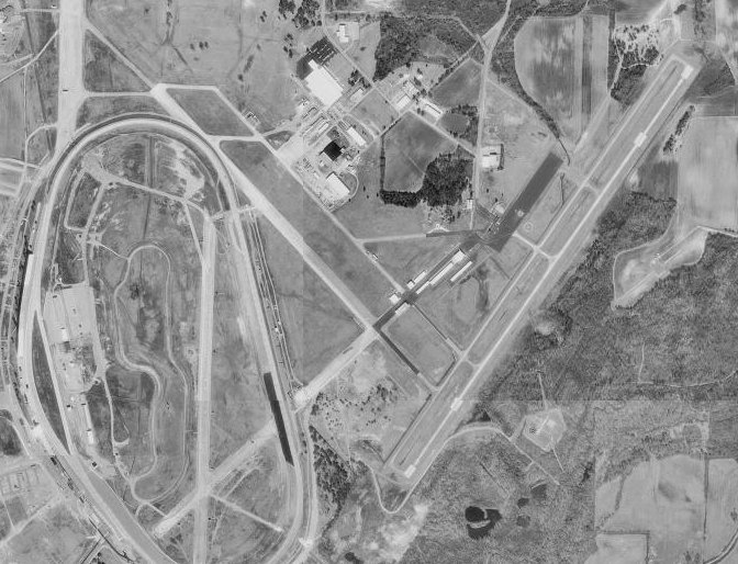
image-width = 250
caption = Talladega Municipal Airport, 4 March 1998
IATA = ASN
ICAO = KASN
FAA = ASN
type = Public
owner =ISC
operator =
city-served =
location =Talladega, Alabama
elevation-f = 529
elevation-m = 161
coordinates = coord|33|34|12|N|086|03|03|W|type:airport_region:US
website =
r1-number = 3/21
r1-length-f = 6,001
r1-length-m = 1,829
r1-surface = Asphalt
stat-year = 2004
stat1-header = Aircraft operations
stat1-data = 41,000
footnotes = Source:Federal Aviation Administration FAA-airport|ID=ASN|use=PU|own=PU|site=00528.1*A, effective 2007-07-05]Talladega Municipal Airport Airport codes|ASN|KASN|ASN is a public-use
airport located eight miles (13 km) northeast of thecentral business district of Talladega, a city in Talladega County,Alabama ,United States . Thisgeneral aviation airport is publicly owned by City of Talladega.Facilities and aircraft
Talladega Municipal Airport covers an area of 1,029
acre s (416 ha) which contains oneasphalt pavedrunway (3/21) measuring 6,001 x 100 ft (1,829 x 30 m). For the 12-month period ending December 31, 2004, the airport had 41,000 aircraft operations, an average of 112 per day: 92%general aviation , 7% military and 2%air taxi .History
During
World War II , theUnited States Army Air Forces used Talladega airport as a training airfield byThird Air Force . It was known asAnniston Army Airfield and was headquartered by the 343d Army Air Force Base Unit.The earliest reference to Anniston AAF which has been located was on the March 1944 US Army/Navy Directory of Airfields. It described Anniston AAF as having a 5,300' hard-surfaced runway. The earliest depiction of Anniston AAF which has been located was on the November 1944 Birmingham Sectional Chart.
The airfield consisted of three 5,300' concrete runways, taxiways, and a ramp & building complex on the northeast side of the field. The role of Anniston AAF has not been determined. Anniston AAF was still depicted as an active military airfield on the 1945 Birmingham Sectional Chart.
At some point between 1945-47, Anniston was apparently closed by the military, as it was labeled
Anniston Air Force Base (Inactive) on a 1947 USGS topo map. The former Anniston AFB was eventually reused as the Talladega Airport. It was described on the Aerodromes table of the August 1954 Birmingham Sectional Chart as a jointly operated (civil & Air Force) airfield. The 1959 Jeppesen Airway Manual depicted Talladega Airport as having three 5,300' paved runways. Taxiways led to a ramp on the north side of the field. Only a single building was depicted The 1962 AOPA Airport Directory described Talladega Municipal Airport as having three 5,300' concrete runways, and listed the operator as Vinson Flying Service.The former Anniston AAF was selected as the site for a new auto racing track by NASCAR founder Bill France & Bill Ward, and the track was opened in 1969. It "was built to be the biggest, fastest, and most competitive speedway in the world."
The date of closure of the Talladega Municipal Airport has not been determined. At an unknown date, a new airport, the Talladega Municipal Airport, was built to the east of the Speedway & former military airfield. A new 6,000' paved runway was constructed for the new airport - it did not reuse any runways from the former military airfield.
See also
*
Alabama World War II Army Airfields References
External links
*
*
Wikimedia Foundation. 2010.