- Serra de Tramuntana
Geobox | Range
name=Serra de Tramuntana

image_caption=View of the Tramuntana mountain range after a winter snow
country=Spain
region=Majorca
parent=
geology=|orogeny=
border=
area= | length= | length_orientation=
width= | width_orientation=
highest=Puig Major
highest_elevation=1445
highest_lat_d=39|highest_lat_m=48|highest_lat_s=|highest_lat_NS=N
highest_long_d=02|highest_long_m=48|highest_long_s=|highest_long_EW=E
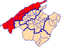
map_caption=Location of the Serra de Tramuntana comarca in MajorcaThe Serra de Tramuntana is amountain range running southwest-northeast which forms the northern backbone of the Spanish island ofMajorca . It is also the name given to the comarca of the same area.Its highest peak is the
Puig Major , which, at its 1,445 metres is the highest mountain in theBalearic Islands .The climate in the Tramuntana Range is markedly wetter than the rest of the island. It is also cooler due to the height and a few days of snow are not unusual during winter.
External links
*
* [http://tramuntana.info/ Serra de Tramuntana info page]
* [http://www.gobmallorca.com/enp/t1/t1.htm Information on the Serra de Tramuntana]
Wikimedia Foundation. 2010.