Maniototo

Maniototo
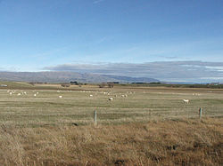
Looking southwest across the Maniototo towards Rough Ridge from near Ranfurly
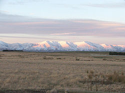
The Kakanui Range dominates the eastern horizon of the Maniototo

The Maniototo Plain, usually simply known as The Maniototo, is an elevated inland region in Otago, New Zealand.[1] The region roughly surrounds the upper reaches of the Taieri River and the Manuherikia River. It is bounded by the Kakanui Range to the north and the Rock and Pillar Range to the southeast. It has a harsh, dry climate, ranging from over 30°C in mid-summer to -15°C in mid-winter.

The region is sparsely populated, with the largest centres being Ranfurly, Naseby, Omakau, and Ophir.

Part of the Canterbury-Otago tussock grasslands the land surrounding the plain is hilly, with many outcrops of rock which also break up the plain in places. The scenery between Omakau and Ranfurly appeared in Peter Jackson's The Lord of the Rings film trilogy as the location for many of the scenes set in Rohan.

During the 1860s the region was one of the sites of the Central Otago goldrush, and relics from that era can still be seen around the towns of Kyeburn, Naseby, and St. Bathans.

Sheep farming is the major source of income. The area is closely associated with the sport of curling. Naseby has the only indoor curling rink and the only natural luge track in the Southern Hemisphere.

See also

References

  1. ^ "Place Name Detail: Maniototo Plain". New Zealand Geographic Placenames Database. Land Information New Zealand. http://www.linz.govt.nz/placenames/find-names/topographic-names-db/database/index.aspx?p=10400. Retrieved 2009-11-15. 

Coordinates: 45°09′13″S 170°02′21″E / 45.1536°S 170.0392°E / -45.1536; 170.0392


Wikimedia Foundation. 2010.

Игры ⚽ Нужно сделать НИР?

Look at other dictionaries:

  • maniototo —   From the Maniototo Plain, South Island, New Zealand …   Etymological dictionary of grasses

  • Maniototo Plain — mit Teil der Ida Range Die Maniototo Plain ist eine von einer Berglandschaft umschlossene fruchtbare Ebene in Otago auf der Südinsel Neuseelands. Inhaltsverzeichnis …   Deutsch Wikipedia

  • Maniototo Area School — By learning we live Location 15 Caulfeild St. Ranfurly …   Wikipedia

  • Poa maniototo — ID 65519 Symbol Key POMA38 Common Name desert poa Family Poaceae Category Monocot Division Magnoliophyta US Nativity Cultivated, or not in the U.S. US/NA Plant Yes State Distribution N/A Growth Habit N/A …   USDA Plant Characteristics

  • Poa maniototo Petrie — Symbol POMA38 Common Name desert poa Botanical Family Poaceae …   Scientific plant list

  • Waipiata — is an historic place located on the Otago Central Rail Trail, in Central Otago, New Zealand. * Waipiata is also the name of many New Zealand maritime Coastal Vessels, Steamers, Freighters, and Steamships.… …   Wikipedia

  • Strath-Taieri — The Strath Taieri is a large glacial valley and river plateau, surrounded by rugged hill ranges located to the north and west of Otago Harbour. Since 1989 it has been part of the city of Dunedin. Middlemarch is located at its southern end. The… …   Wikipedia

  • Ranfurly (Neuseeland) — Ranfurly …   Deutsch Wikipedia

  • Ranfurly, New Zealand — RanfurlyUrban AreaPopulation1,060 (2006)Territorial AuthorityNameCentral Otago District Council (see Alexandra)Population16,950 (2006 est.)ExtentIncludes the towns of Alexandra Clyde, Cromwell, Roxburgh, and Ranfurly Regional …   Wikipedia

  • Kakanui Range — Die Kakanui Mountains dominieren den östlichen Horizont von Maniototo Die Kakanui Mountains oder Kakanui Range sind eine Bergkette im Hinterland von Oamaru auf dern der Südinsel Neuseelands. Sie gehören administrativ zum Waitaki Distrikt, der… …   Deutsch Wikipedia

Share the article and excerpts

Direct link
Do a right-click on the link above
and select “Copy Link”