- Dunston Pillar
-
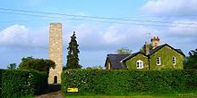 Dunston Pillar in 2004
 Bust of George III from the pillar, now at Lincoln Castle.
Dunston Pillar is a grade II listed stone tower in Lincolnshire, England and a former 'land lighthouse'.[1] It stands beside the A15 road approximately 10 km (6 mi) south of Lincoln near the junction of the B1178 (also known as Tower Lane), in the village of Dunston.
History
The original land lighthouse was commissioned by Sir Francis Dashwood[2] (better known as the founder of the Knights of St. Francis, which became the Monks of Medmenham, later called a Hellfire Club) in 1751 as a gift to his wife Sarah (Ellys) Dashwood, who feared crossing the dark heath near her childhood home, Nocton. The purpose of the land lighthouse was to improve the safety of 18th century travellers crossing a particularly treacherous area of the county known for its many incidents of highway robbery (including a number believed to have been carried out by the notorious highwayman, Dick Turpin).
The structure originally stood 30 metres high (90 ft) with a large octagonal lantern on top of the tower.[2] The lantern was regularly lit until 1788 and was used for the last time in 1808 by which time improvements in the local road network had effectively made it obsolete.
Sir Francis landscaped the base of Dunston Tower with a plantation of trees, and a bowling green. It became a popular gathering place for picnics, tea parties, quoits and cards. A two story dining hall was later added. The vicar of Welbourn called it "the Vauxhall" of Lincolnshire, and The Lincoln Club was formed to arrange entertainments there.
In 1808, the lantern was destroyed in a storm and was replaced in 1810 by Earl of Buckinghamshire, in celebration of fifty years of the king's reign, with a Lithodipyra (Coade stone) bust of King George III sculpted by Joseph Panzetta for Eleanor Coade.[2]
In 1940, the pillar was considered to be a hazard to low-flying aircraft approaching nearby RAF Coleby Grange, and was thus lowered by 10 metres to reduce the risk of accident. At this time the bust of King George III was removed and can now be seen in the grounds of Lincoln Castle.[2]
The tower remains a well-known landmark and to this day is clearly visible beside the busy road at grid reference TF008620
References
- ^ "Dunston Pillar". National Heritage List for England. English Heritage. http://list.english-heritage.org.uk/resultsingle.aspx?uid=1061942. Retrieved 2 July 2011.
- ^ a b c d "Dunston Pillar". Pastscape. English Heritage. http://www.pastscape.org.uk/hob.aspx?hob_id=349474&sort=4&search=all&criteria=Dunston,%20Lincolnshire&rational=q&recordsperpage=20. Retrieved 2 July 2011.
External links
Categories:- Buildings and structures in Lincolnshire
- Monumental columns in the United Kingdom


Wikimedia Foundation. 2010.