- Washington State Route 16
Infobox WA State Route|type=State|route=16|sec=065
length_mi=27.01
length_ref=
length_round=2
formed=1964
dir1=East
dir2=West
from=
junction=
to=
next_type=State|previous_type=State|next_route=17|previous_route=14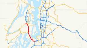
State Route 16 is a
state highway inWashington ,U.S.A. It extends just over 27 miles (43 km) from Tacoma in the southeast to Gorst in the northwest.Route description
SR 16 originates at Interstate 5, runs through the city of Tacoma, and crosses the
Tacoma Narrows ofPuget Sound on theTacoma Narrows Bridge to Gig Harbor on theKitsap Peninsula . From there, it continues northwest past Burley, Bethel, and Port Orchard, and ends at State Route 3 in Gorst, at the western end ofSinclair Inlet .SR 16 is a
freeway for its entire length with the exception of a single remainingat-grade intersection with Burley-Olalla Road two miles north of the Pierce-Kitsap county line and localdriveway access north of Gig Harbor and in Gorst. TheWashington State Department of Transportation has initiated a project to transform the intersection to a grade-separateddiamond interchange , with construction scheduled to begin in2008 . [ [http://www.wsdot.wa.gov/Projects/SR16/BurleyOlalla/ WSDOT - Project - Projects - SR 16 - Burley Olalla Interchange ] ] WSDOT has considered various options at the driveways north of Gig Harbor to improve safety.Although the route of SR 16 is geographically runs north-south, its even number indicates an east-west route, and is usually signed as such, with the western terminus in at State Route 3 in a town called Gorst which is near
Bremerton on theKitsap Peninsula and the eastern terminus at Interstate 5 in Tacoma. The mileposts on SR 16 are also said by some individuals to be 'backwards'. Typically an east-west highway starts its mileposts from the western terminus and get larger eastbound. SR 16 mileposts begin at Interstate 5 and get larger westbound. There is also a 3 mile gap in the mileposts at the Tacoma Narrows bridge. This is due to the pre-freeway routing which began at Interstate 5 at Pacific Ave. SR 16 followed Pacific Ave north into downtown Tacoma, then turned west onto 6th St. SR 16 followed 6th St west under the current SR 16 freeway, and then turned northwest onto Olympic Boulevard which led to the Narrows Bridge. The once 4 lane Olympic Blvd has been converted to a city park.In 2002, WSDOT began a project to build a second parallel
Tacoma Narrows Bridge crossing. The new bridge is being designed to resemble the existingSuspension Bridge . The old bridge will carry westbound traffic without a toll, while its sister structure will carry eastbound traffic and have a $3.00 toll. The new eastbound bridge was officially opened to traffic on July 16, 2007. It also premiered a newRFID technology, christened theGood To Go! pass, which allows frequent users to bypass the toll booths by way of a prepaid transponder placed on the inside of the windshield. TheGood To Go! pass also reduces the toll to $1.75.At the eastern Terminus, SR 16 crosses the Nalley Valley
viaduct . The viaduct's uniquetetrapod structure prevents widening, as well as the close proximity of the Interstate 5 and Sprague Ave interchanges. The viaduct will be completely rebuilt in stages beginning in 2009 and be completed in 2013.SR 16 has also become the second state highway in Washington State to have exit numbers posted at interchanges. The only other state highway that has numbered exits is SR 14 in the Vancouver area.
Future developments
Along with the twinning of the Tacoma Narrows Bridge, several expansion projects are underway as part of a revitalization of freeways in the Tacoma/Pierce County area. Completed projects include the twinning of the Tacoma Narrows Bridge, widening between Gig Harbor and I-5 to include HOV lanes and auxiliary lanes, and redesigning several interchanges to improve traffic flow. The last project to be completed on SR 16 is rebuilding the Nalley Valley viaduct for a new, expanded interchange with I-5 [ [http://www.wsdot.wa.gov/Projects/PierceCountyHOV/SR16_WBNalleyValley/ WSDOT - Project - SR 16 - Westbound Nalley Valley ] ] [ [http://www.wsdot.wa.gov/Projects/PierceCountyHOV/ WSDOT - Project - Tacoma/Pierce County HOV Program ] ] .
Exit list
Related routes
External links
* [http://www.angelfire.com/wa2/hwysofwastate/sr016.html Highways of Washington State]
References

Wikimedia Foundation. 2010.