Gouwe River

Gouwe River

Geobox River
name = Gouwe
native_name =
other_name =
other_name1 =


image_size = 220
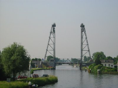
image_caption = Vertical lift bridge over the river Gouwe at Alphen aan den Rijn.
country = The Netherlands
country1 =
state = South Holland
state1 =
region =
region1 =
district =
district1 =
city =
city1 =
length = 14
watershed =
discharge_location =
discharge_average =
discharge_max =
discharge_min =
discharge1_location =
discharge1_average =
source_name = Oude Rijn
source_location = Alphen aan den Rijn
source_district =
source_region =
source_state = South Holland
source_country =
source_lat_d =
source_lat_m =
source_lat_s =
source_lat_NS =
source_long_d =
source_long_m =
source_long_s =
source_long_EW =
source_elevation =
source_length =
mouth_name = Hollandse IJssel
mouth_location = Gouda
mouth_district =
mouth_region =
mouth_state = South Holland
mouth_country =
mouth_lat_d =
mouth_lat_m =
mouth_lat_s =
mouth_lat_NS =
mouth_long_d =
mouth_long_m =
mouth_long_s =
mouth_long_EW =
mouth_elevation =
tributary_left =
tributary_left1 =
tributary_right =
tributary_right1 =
free_name =
free_value =


map_size = 220
map_caption = Location of the Gouwe in dark blue.

The Gouwe is a channelized river in South Holland, the Netherlands. It runs in a north-south direction from the Oude Rijn to the Hollandse IJssel.

From Alphen aan den Rijn, where the Gouwe begins at the Gouw Locks, it flows through Boskoop and Waddinxveen to Gouda. Here it splits into the old stream through the city and into the Gouwe Canal on the city's west side.

The Gouwe was historically part of the primary (and prescribed) shipping route in Holland, connecting Dordrecht with Haarlem and later on Amsterdam. These cities, together with the Counts of Holland who collected toll at Gouda and Spaarndam, maintained this arrangement to the dissatisfaction of the cities Delft and Leiden which were bypassed by this route.

Today the Gouwe is still an important shipping route. At the Oude Rijn, river travel can be continued north over the Aar Canal. It also functions as the main water outlet for the Rijnland region.

Three striking vertical lift bridges cross the Gouwe at Alphen aan den Rijn, Boskoop, and Waddinxveen.


Wikimedia Foundation. 2010.

Игры ⚽ Нужна курсовая?

Look at other dictionaries:

  • Aqueduct — An aqueduct is an artificial channel that is constructed to convey water from one location to another. The word is derived from the Latin aqua , water, and ducere ( to lead ). The word is also used for any bridge that carries water, similar to… …   Wikipedia

  • Navigable aqueduct — See also: List of canal aqueducts in Great Britain Narrowboat crossing the World Heritage Pontcysyllte Aqueduct in Wales …   Wikipedia

  • Gouda — Infobox Settlement official name = Gouda flag size = 120x100px image shield = Wapen gouda.gif shield size = 120x100px mapsize = 280px subdivision type = Country subdivision name = Netherlands (Nederland) subdivision type1 = Province subdivision… …   Wikipedia

  • Waddinxveen — Infobox Settlement official name = Waddinxveen flag size = 120x100px image shield = Waddinxveen coa.jpg shield size = 120x100px mapsize = 280px subdivision type = Country subdivision name = Netherlands subdivision type1 = Province subdivision… …   Wikipedia

  • Rhein-Maas-Delta — Mündungsgebiet von Rhein und Maas. Im Vordergrund u. a. die Rotterdamer Hafenanlagen und der Haringvliet …   Deutsch Wikipedia

  • Boskoop — Infobox Settlement official name = Boskoop flag size = 120x100px image shield = Coat of arms of Boskoop.png shield size = 120x100px mapsize = 280px subdivision type = Country subdivision name = Netherlands subdivision type1 = Province subdivision …   Wikipedia

  • German placename etymology — Placenames in the German language area can be classified by the language from which they originate, and by their age. German names from prehistoric and medieval times Suffixes # with the suffix au , aue (related to rivers or water), see German… …   Wikipedia

  • List of rivers of the Netherlands — These are the main rivers of the Netherlands. All of the Netherlands is drained into the North Sea, partly via the IJsselmeer lake. In the list below, rivers that flow into the sea are sorted following the North Sea coast (including IJsselmeer)… …   Wikipedia

  • Gouwestreek — The Gouwestreek (a Dutch word meaning the Gouwe area ) is the area around Gouda in the province of South Holland in the Netherlands. Gouwe refers to the (now canalised) river Gouwe, which runs though Gouda. The Gouwestreek is not an official or… …   Wikipedia

  • Oude Rijn (Utrecht and South Holland) — For the Oude Rijn branch in Gelderland Province, see: Oude Rijn (Gelderland). Coordinates: 52°12′43″N 4°23′54″E / 52.21194°N 4.39833°E …   Wikipedia

Share the article and excerpts

Direct link
Do a right-click on the link above
and select “Copy Link”