Gelai Volcano

Gelai Volcano
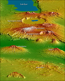
Topographical map of the Crater Highlands, looking from the north to the southwest. Gelai is to the right

The Gelai Volcano stands at 9,652ft (2,942m) tall and is located in Tanzania in the Crater Highlands region. It is at the southeastern edge of Lake Natron in Africa's Great Rift Valley. The volcano falls within a game-controlled area that extends east to Longido, where hunting is permitted. This has caused a drop in the numbers of animals in the area. Coordinates: 2°37′09″S 36°06′01″E / 2.61917°S 36.10028°E / -2.61917; 36.10028

See also


Wikimedia Foundation. 2010.

Игры ⚽ Поможем написать курсовую

Look at other dictionaries:

  • Gelai — Mont Gelai Mont Gelai Le mont Gelai dominant le lac Natron logé dans la vallée du grand rift Géographie Altitude …   Wikipédia en Français

  • Mont Gelai — Le mont Gelai dominant le lac Natron logé dans la vallée du grand rift Géographie Altitude 2 942 m Massif …   Wikipédia en Français

  • Natron, Lake — ▪ lake, Tanzania       lake in northern Tanzania on the border with Kenya, lying in the East African Rift System, 70 miles (113 km) northwest of Arusha. The lake is 35 miles (56 km) long and 15 miles (24 km) wide and contains salt, soda, and… …   Universalium

  • Monduli —   District   Map of Arusha Region s Districts with Monduli highlighted. Country Tanzania …   Wikipedia

  • Crater Highlands — Topographical map of the Crater Highlands, looking from the north to the southwest. The Crater Highlands are a region along the East African Rift in Tanzania, located in a spreading zone at the intersection of branches of the African and Somali… …   Wikipedia

  • Kilimandjaro — Pour les articles homonymes, voir Kilimandjaro (homonymie). Kilimandjaro Le sommet du Kibo, 5 892 m d altitude (en décembre 2006) …   Wikipédia en Français

Share the article and excerpts

Direct link
Do a right-click on the link above
and select “Copy Link”