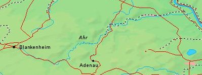
- Ahr
Infobox River | river_name = Ahr

caption = Map of the Ahr
origin =Eifel
mouth =Rhine
basin_countries =Germany
length = 86 km
elevation = 520 m
discharge =
watershed = ±900 km²The Ahr is ariver inGermany , a left tributary of theRhine . Its source is at a height of approximately 520 meters above sea level in Blankenheim in theEifel , in the cellar of a half-timbered house near the castle of Blankenheim. After 18 kilometers it crosses fromNorth Rhine-Westphalia intoRhineland-Palatinate .The Ahr flows through the towns
Schuld ,Altenahr andBad Neuenahr-Ahrweiler . BetweenRemagen andSinzig (south ofBonn ), at about 50 m above sea level, it flows into the Rhine. The length is approx. 86 km, of which 68 kilometers within Rhineland-Palatinate. The Ahr has a gradient of 0.4% in its lower course, and 0.4-0.8% in its upper course.The Ahr and its tributaries are a main drainage system of the eastern
Eifel . The watershed is approximately 900 km². Tributaries of the Ahr are (from the mouth to the source):Harbach (Ahr) ,Hellenbach ,Bachemer Bach ,Leimersdorfer Bach ,Liersbach ,Vischelbach ,Sahrbach ,Kesselinger Bach ,Armuthsbach ,Dreisbach (brook) ,Eichenbach ,Adenauer Bach ,Trierbach andAhbach .There were isolated settlements in the Ahr valley at the latest since the Roman times, evidenced by the Roman mansion near Ahrweiler. Due to its isolated position, the upper and middle course were sparsely populated.
That changed from the mid-19th century. The development of the settlements, the traffic routes and the agricultural areas in the Ahr valley led to the fact that the riverbed was fixed.
The Ahr valley makes up the Ahr wine region, which is small but noted for its red wines made from the
Spätburgunder variety.External links
* [http://www.ahrtalguide.com AhrtalGuide.com] Pictures of this region de icon
* [http://www.ahrxwein.de Ahrweine] de icon
* [http://www.ahr-2000.de/start.html Ahr 2000 ] de icon
Wikimedia Foundation. 2010.
