- Oregon Route 350
-
Oregon Route 350
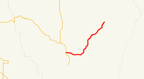
Route information Maintained by ODOT Length: 29.36 mi (47.25 km) Existed: 2003 – present Major junctions West end: 
 OR 82 and OR 351 in Joseph
East end: Upper Imnaha Road and Grizzly Ridge Road in Imnaha Highway system Oregon highways
Routes • Highways←  OR 339
OR 351 →Oregon Route 350 is an Oregon state highway running from Joseph to Imnaha. OR 350 is known as the Little Sheep Creek Highway No. 350 (see Oregon highways and routes). It is 29.36 miles (47.25 km) long and runs east–west, entirely within Wallowa County.
OR 350 was established in 2003 as part of Oregon's project to assign route numbers to highways that previously were not assigned, and, as of August 2009, was unsigned.
Contents
Route description
OR 350 begins at an intersection with OR 82 and OR 351 in Joseph and heads east and northeast to Imnaha, where it ends at the intersection of Upper Imnaha Road and Grizzly Ridge Road.
History
OR 350 was assigned to the Little Sheep Creek Highway in 2003.
Major intersections
Milepost City Intersection 0.00 Joseph OR 82 and OR 351 29.36 Imnaha End Route References
- Oregon Department of Transportation, Descriptions of US and Oregon Routes, http://www.oregon.gov/ODOT/HWY/TRAFFIC/TEOS_Publications/PDF/Descriptions_of_US_and_Oregon_Routes.pdf, page 30.
- Oregon Department of Transportation, Little Sheep Creek Highway No. 350, ftp://ftp.odot.state.or.us/tdb/trandata/maps/slchart_pdfs_1980_to_2002/Hwy350_1996.pdf
Categories:- State routes in Oregon
- Transportation in Wallowa County, Oregon


Wikimedia Foundation. 2010.