- Hangzhou Bay Bridge
Infobox Bridge
bridge_name = Hangzhou Bay Bridge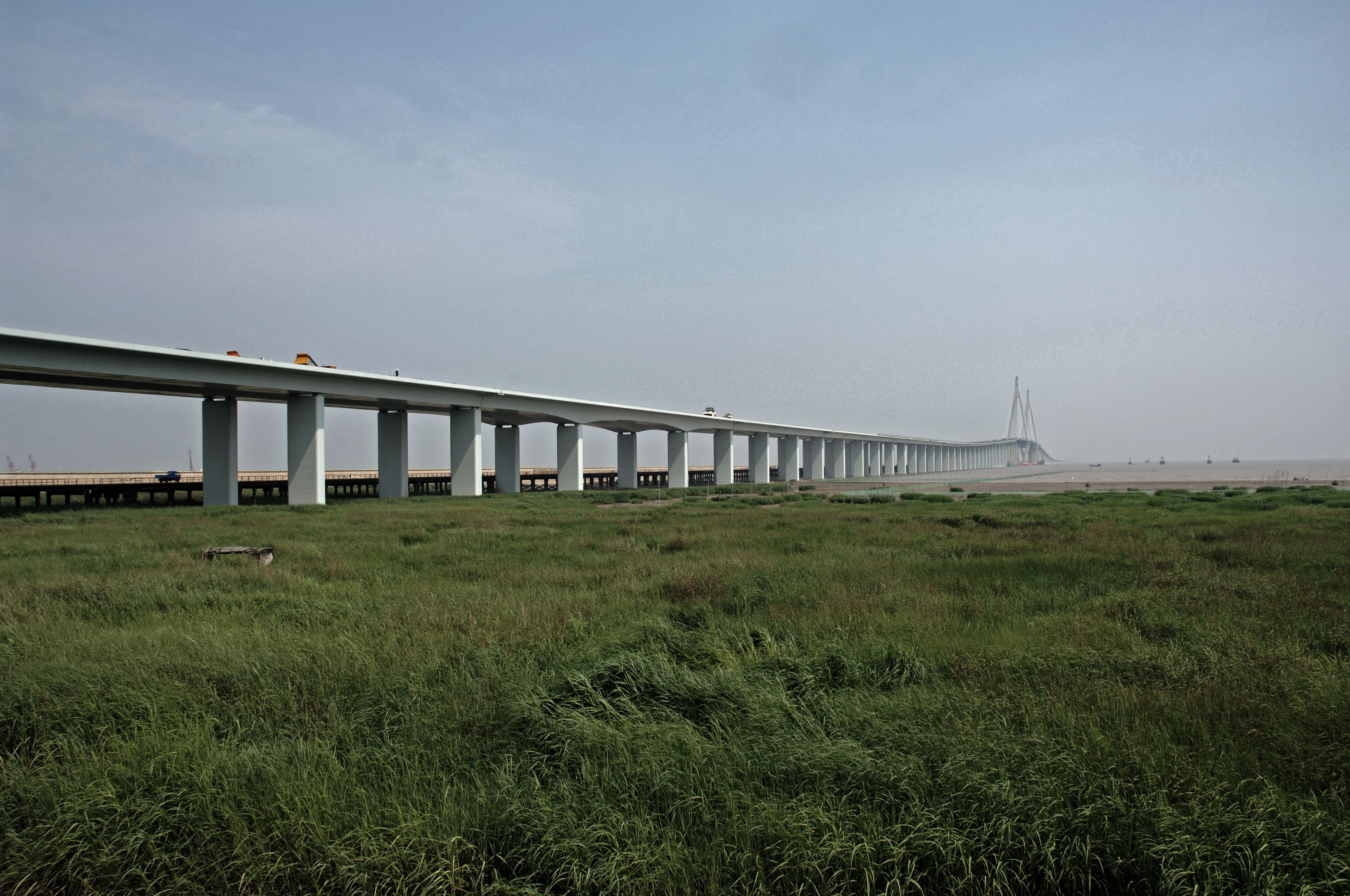
caption =
official_name =
carries = 6 lanes of expressway
crosses =Hangzhou Bay
locale =Jiaxing /Cixi City
mainspan = convert|448|m|ft|0|lk=on|abbr=on
length = convert|35.673|km|mi|0|lk=on|abbr=on
begin =June 8 2003
complete =June 26 2007
open =May 1 2008
toll = yes
map_
map_text = Location of bridge
map_width = 300px
coordinates = coord|30|27|N|121|08|E|display=inline,title|region:CN-33_type:landmark_scale:500000|display=inline,titleHangzhou Bay Bridge (zh-stp|s=杭州湾大桥|t=杭州灣大橋|p=Hángzhōu Wān Dàqiáo), is a bridge with
cable-stayed bridge portion acrossHangzhou Bay off the eastern coast ofChina . It was linked up onJune 14 ,2007 , [cite news |url=http://english.people.com.cn/200706/19/eng20070619_385488.html |publisher=People's Daily Online |title=World's longest trans-sea bridge linked up successfully |accessdate=2008-05-03] and connects themunicipalities ofShanghai andNingbo inZhejiang province. The bridge is the longest trans-oceanic bridge in the world, although it does not have the longest cable-stayed main span. The opening ceremony was held onJune 26 ,2007 with great domestic media publicity, though after the opening ceremony, the bridge would only be used for test and evaluation purposes. It was opened to the public onMay 1 ,2008 . [cite news |url=http://english.people.com.cn/90001/90776/90884/6402247.html |publisher=People's Daily Online |title=World's longest sea bridge to open in east China |accessdate=2008-05-03]Description
Construction of this bridge started on
June 8 ,2003 . The bridge itself is convert|35.673|km|mi|0|lk=on long with six expressway lanes in two directions. The bridge has two main spans, with a convert|448|m|ft|0|lk=on|adj=on northern span, and a convert|318|m|ft|0|adj=on southern span. [cite web |url=http://www.roadtraffic-technology.com/projects/hangzhou/ |publisher=Road Traffic Technology |title=Hangzhou Bay Bridge, China |accessdate=2008-05-03] The designated speed is convert|100|km/h|mph|0|lk=on, and the designed longevity is more than 100 years. The total investment on the bridge was RMB 11.8 billion (US$ 1.4 billion as of December 2004). 35% of this amount was raised from private companies in Ningbo, 59% was provided as loans from China's central and regional banks. Orthotropic steel deck is used on its main spans and five ramp bridges, and was paved with convert|50|mm|in|1|lk=on epoxy asphalt concrete. The bridge is shaped in an 'S', presumably so that the annual Silver Dragon (a particularly strong tidal wave [http://www.tidalbore.info/china/qiantang.html] ) is minimally affected.The length of the bridge is decorated with flashing lights of different colors to distract from drowsiness, and keep attention on the road instead. This is also the real reason for 'S' shape.Fact|date=September 2008History
The bridge underwent various feasibility studies for a decade before it was finally approved in 2003. The original plan was for the northern end of the bridge to start at Jinshan, a suburb of Shanghai. After objections were raised by the Shanghai Municipal Government, however, it was shifted south to the territory of Zhejiang province. The Hangzhou Bay Bridge connects
Cixi City , west of Ningbo, toJiaxing . Whereas previously the trip from Ningbo to Shanghai and southernJiangsu involved a detour of around convert|400|km|mi|0|abbr=on, the bridge reduces that distance to convert|80|km|mi|0|abbr=on, a reduction of convert|320|km|mi|0|abbr=on. The result is that Ningbo, with its port atBeilun , will be able to compete with Shanghai's portPudong for internationalsea freight .Service centre
There will be a service centre on this expressway. Mid-way through the bridge, a service island will be built for cars to turn off the road for rest, food, hotel, top of the line conference room, a lookout tower shaped like a ball and a wide-range of services. The island is actually a platform resting on piers, thus it will not impede the normal sea current in the Bay.
References
External links
* http://www.chinapage.org/bridge/hangzhou/hangzhoubaybridge.html
* http://www.hangzhoubaybridge.com/bridge.asp
*
* [http://maps.google.com/maps?f=q&q=30.562889156631,121.048114299770006&ie=UTF8&ll=30.572723,121.043673&spn=0.003155,0.007167&t=h&z=18 Satelite Photo from Google Map]
Wikimedia Foundation. 2010.