- Kennecott, Alaska
Infobox_nrhp2 | name =Kennecott Mines
nrhp_type = nhld
nhld = yes
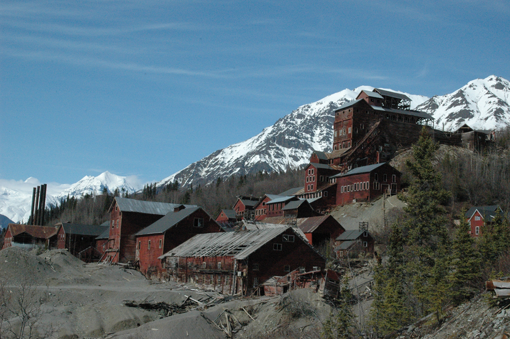
caption = The Kennecott Concentration and smelting plant, the mines are in the mountains to the east
nearest_city=Kennecott, Alaska
lat_degrees = 61
lat_minutes = 30
lat_seconds = 36
lat_direction = N
long_degrees = 142
long_minutes = 52
long_seconds = 5
long_direction = W
locmapin = Alaska
area =7,700 acres
built =1911
architect= Kennecott Mines Co.; Et al.
architecture= No Style Listed
designated_nhl=June 23 ,1986 cite web|url=http://tps.cr.nps.gov/nhl/detail.cfm?ResourceId=1800&ResourceType=District
title=Kennecott Mines |accessdate=2008-06-25|work=National Historic Landmark summary listing|publisher=National Park Service]
added =July 12 ,1978 cite web|url=http://www.nr.nps.gov/|title=National Register Information System|date=2008-04-15|work=National Register of Historic Places|publisher=National Park Service]
governing_body = National Park Service [Is governing body Private (as listed in NRIS), or National Park Service, or mixed?]
refnum=78003420Kennecott, also known as Kennecott Mines or AHRS Site No. XMC-001, is an abandoned mining camp in the Valdez-Cordova Census Area in the
U.S. state ofAlaska that was the center of activity for severalcopper mines. The camp and mines are now aNational Historic Landmark District administered by theNational Park Service . It is located north of Valdez at coord|61|29|10|N|142|53|19|W|, insideWrangell-St. Elias National Park and Preserve .It was declared a
National Historic Landmark in 1986.citation|title=PDFlink| [http://pdfhost.focus.nps.gov/docs/NHLS/Text/78003420.pdf National Register of Historic Places Inventory-Nomination: Kennecott Mines] |32 KB|date=1983-1986(?) |author=Robert Pierce and Robert Spude |publisher=National Park Service and PDFlink| [http://pdfhost.focus.nps.gov/docs/NHLS/Photos/78003420.pdf "Accompanying seven photos, exterior and interior, from ca. 1925, ca. 1930, 1983"] |32 KB]History
In August 1900, two prospectors, Jack Smith and Clarence Warner, spotted a green patch of hillside that looked like good grazing for their pack horses. The green turned out to be part of a mountain of copper ore. They, together with nine friends, formed the Chitina Mining and Exploration Company. Shortly after this time, a
U.S. Geological Survey geologist found a sample of ore that analyzed as containing 70% copper as well assilver and traces ofgold . Stephen Birch, a mining engineer just out of school, was in Valdez when members of the Chitina Mining and Exploration Company arrived in the fall of 1900. Birch, who knew wealthy people in the northeastern United States, bought the prospectors' interest in the mine for $275,000. Within twenty years, the find proved to be the richest known concentration of copper in the world.Development of the mines began immediately. Ore was taken out by pack horses on a trail to Valdez. Political battles over the mining and subsequent railroad were fought in the office of U.S. President
Theodore Roosevelt between conservationists and those having a financial interest in the copper.In 1903, additional financing for the mining came from the
Guggenheim family andJ.P. Morgan , who formed the Kennecott Copper Corporation in 1903. The corporation and company town were named afterKennicott Glacier , which was situated in the valley below the town. The glacier was named afterRobert Kennicott , a naturalist who explored in Alaska in the mid-1800s. Due to a clerical error, the corporation and town used the spelling of "Kennecott" instead of "Kennicott." It is occasionally also seen as "Kennycott."Kennecott had five mines: Bonanza, Jumbo, Mother Lode, Erie and Glacier. Glacier, which is really an ore extension of the Bonanza, was an open-pit mine and was only mined during the summer. Bonanza and Jumbo were on Bonanza Ridge about 5 km, (3 miles) from Kennecott. The Mother Lode mine was located on the east side of the ridge from Kennecott. The Bonanza, Jumbo, Mother Lode and Erie mines were connected by tunnels. The Erie mine was perched on the northwest end of Bonanza Ridge overlooking Root Glacier about 6 km (4 miles) up a glacial trail from Kennecott. Ore was hoisted to Kennecott via the trams which head-ended at Bonanza and Jumbo. From Kennecott the ore was hauled mostly in 140-pound sacks on steel flat cars to Cordova, 196 rail miles away on the
Copper River and Northwestern Railway (CRNW).On
April 8 ,1911 , the first ore train hauled $250,000 of 70% copper ore. In 1916, the peak year for production, the mines produced copper ore valued at $32.4 million.In 1925 a Kennecott geologist predicted that the end of the high-grade ore bodies was in sight. The highest grades of ore were largely depleted by the early 1930s. The Glacier Mine closed in 1929. The Mother Lode was next, closing at the end of July 1938. The final three, Erie, Jumbo and Bonanza, closed that September. The last train left Kennecott on
November 10 ,1938 , leaving it a ghost town. In the 27 years of operation, except for 2 1/2 years of shutdown, Kennecott produced 4.625 million tons of ore averaging 13 per cent copper valued at roughly $207,000,000 with an estimated profit of $100,000,000. In addition, the silver by-product from this operation brought in another 4 1/2 to 9 million dollars in revenues.From 1939 until the mid-1950s, Kennecott was deserted except for a family of three who served as the watchmen until about 1952. In the late 1960s, an attempt was made to reprocess the tailings and to transport the ore in aircraft. The cost of doing so made the idea unprofitable. Around the same time, the company with land rights ordered the destruction of the town to rid them of liability for potential accidents. A few structures were destroyed, but the job was never finished and most of the town was left standing. Visitors and nearby residents have stripped many of the small items and artifacts. Some have since been returned and are held in various archives.
Tourism
In the 1980s, Kennecott became a somewhat popular tourist destination, as people came to see the old mines and buildings. However, the town of Kennecott was never repopulated. Residents involved in the tourism industry often lived in nearby McCarthy or on private land in the surrounding area. The area was designated a
National Historic Landmark in 1986 and theNational Park Service acquired much of the land within the Kennecott Mill Town in 1998. The National Park Service is currently stabilizing and rehabilitating many of the mill and town buildings. Some of the structures, as well as surrounding lands, remain under private ownership. Tours of the mill town are available three times a day through a local guide service, St. Elias Alpine Guides.Popular tourist activities while visiting Kennecott include
glacier hiking,ice climbing , and touring the abandoned mill. Visitors may also hike to the abandoned Bonanza, Jumbo and Erie mines, all of which are strenuous full-day hikes, with Erie Mine being a somewhat terrifying scramble along cliffs overlooking the Stairway Icefall. Local guide services offer all of these hikes if you would like some route-finding assistance.Accessibility
Kennecott is now accessible by air (McCarthy has a 500 m/1,500 foot gravel runway) or by driving on the
Edgerton Highway to theMcCarthy Road , an unimproved gravel road. The McCarthy Road ends at theKennicott River and a footbridge is available for pedestrian traffic to McCarthy. From McCarthy, it is 4.5 miles to Kennecott, and shuttles are available.References
External links
* - images of the town and mine
* [http://lcweb2.loc.gov/pp/hhquery.html Photosets of several mine buildings available by searching on "Kennecott AK" here] , atHistoric American Building Survey
* [http://www.largestnationalpark.com/history.html History of Kennecott]
Wikimedia Foundation. 2010.