- Middleton Park
-
Middleton Park
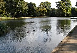
Lakein Middleton ParkType Parkland, woodland, lake Location Middleton, West Yorkshire, England Area 630 acres (2.5 km2) Created 1920 Operated by Leeds City Council Website Middleton Park Middleton Park is a public park in Middleton, Leeds, West Yorkshire, England. It covers an area of 630 acres (255 ha), nearly a square mile of which 200 acres (80.9 ha) are ancient woodland. There is also a small lake, recreational areas and a golf course.[1] The reclaimed site of "Middleton Broom" Colliery has been incorporated into the park. By its northern boundary is the South Leeds Stadium, home of Hunslet Rugby League Club. The Middleton Railway runs between Moor Road, Hunslet and Park Halt.
History
Middleton Park is a remnant of the manorial estate which existed after the Norman Conquest. Middleton is mentioned in the Domesday Book of 1086. At the northern end of park there is an earthwork from 1204 demarcating the boundary between Middleton and Beeston. Lords of the manor included the Grammarys, Creppings, Leghs and Brandlings. The Brandlings cleared land and built Middleton Lodge in about 1760, creating a country estate.[2] The Brandlings exploited the underlying coal and were responsible for building the Middleton Railway to transport the coal into Leeds.[3]
Since 1919 it has been in the ownership of Wade's Charity who lease it to Leeds City Council for a peppercorn rent.[4] It has been one of Leeds many public parks since 1919.
Archaeology
The area contains a large number of "shaft mounds" which are thought to mark sites of medieval mining. Survey work was done in 2007–2008 to discover more about the mounds, which seem to represent various mining techniques, including bell pits, cog and rung and whim gins. The professional archaeologist Martin Roe led the team from the Friends of Middleton Park and the South Leeds Archaeology Group.[4]
References
- Notes
- ^ Middleton Park, leeds.gov.uk, http://www.leeds.gov.uk/page.aspx?pageidentifier=63939FAC8F1A7A5B80256E1B003F7561, retrieved 2009-09-22
- ^ Roe (2008), p. 1.
- ^ Roe (2008), p. 2.
- ^ a b About the Park, lfomp.co.uk, http://www.fomp.co.uk/html/about-park.htm, retrieved 2009-09-23
- Bibliography
- Illing, Rev. E. J. (1971), A History of the Parish of Middleton and its Parish Church, Middleton Parish Church
- Roe, Martin (2008), Coal Mining in Middleton Park, Meerstone, ISBN 978-0-9559477-0-4
Coordinates: 53°45′25″N 1°32′53″W / 53.757°N 1.548°W
Categories:- Parks and commons in Leeds
- West Yorkshire geography stubs
Wikimedia Foundation. 2010.

