- Texas State Highway 315
Infobox TX State Highway
type=State
route=315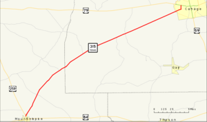
length_mi=26.035
length_ref=TxDOT|SH|315|accessdate=2008-03-15]
length_round=3
formed=by 1939
dir1=West
dir2=East
from=jct|state=TX|US|259 in Mount Enterprise
junction=
to=jct|state=TX|US-Bus|79|dab1=Carthage in Carthage
previous_type=State
previous_route=314
next_type=State
next_route=316State Highway 315 or SH 315 is a Texas state highway that runs from Mount Enterprise northeast to Carthage. The route was designated by 1939.
Route description
SH 315 begins at a junction with US 259 in Mount Enterprise. It heads northeast from this junction to an intersection with FM 95. The highway continues to the northeast to an intersection with FM 840. Heading towards the northeast, the highway continues to an junction with FM 348. The highway continues to the northeast to an intersection with FM 1971. It continues to the northeast to a junction with FM 1970. As the highway continues to the northeast, it intersects SH 149 in Carthage. SH 315 reaches its eastern terminus at US 79 Bus. in Carthage.cite map|publisher=
Google Maps |title=Overview map of SH 315|accessdate=2008-03-15|url=http://maps.google.com/maps?f=d&hl=en&geocode=10812107098098046854,31.925067,-94.682881%3B9709246601343979203,32.158650,-94.357480&saddr=TX-315+%4031.925067,+-94.682881&daddr=W+Panola+St%2FUS-79-BR+%4032.158650,+-94.357480&doflg=ptm&sll=32.04186,-94.52015&sspn=0.274141,0.466919&ie=UTF8&z=11]Junction list
References

Wikimedia Foundation. 2010.