Cézembre

Cézembre
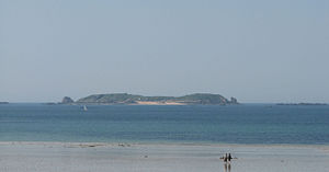
Cézembre, seen from the Sillon beach, Saint-Malo

Cézembre is an island in the Ille-et-Vilaine département of France, near Saint-Malo. The island is uninhabited, with a surface area of approximately 18 hectares (44 acres), a length of 750 meters, and a width of 300 meters.

The island features a fine sand beach facing Saint-Malo on the south, and a steep and rocky coast around the rest of the island.

Cézembre was inhabited by a number of hermits over the centuries, and featured a monastery for a time. Vauban fortified the island at the end of the 17th century, and it was used thereafter as a place of quarantine.

During World War I, the Belgian Army installed a disciplinary company on Cézembre. During World War II, the island's fortifications were strengthened by the Germans and Italians as part of the Atlantic Wall. The Normandy campaign in the summer of 1944 saw the German-Italian garrison heavily bombarded by land artillery, naval artillery, and air strikes, including some of the first uses of napalm bombs. The island surrendered to elements of the U.S. 83rd Infantry Division at the beginning of September, 1944.

As a result of this intense Allied bombardment, Cézembre's landscape is barren, with little vegetation to this day. The island has not yet been completely demined, and for this reason most of the island other than the beach constitutes a zone interdite (prohibited zone).

Cézembre is claimed as territory by the unrecognised micronation of Talossa.


External links

Coordinates: 48°40′36″N 2°4′17″W / 48.67667°N 2.07139°W / 48.67667; -2.07139


Wikimedia Foundation. 2010.

Игры ⚽ Нужно решить контрольную?

Look at other dictionaries:

  • Cézembre — vue du bateau navette Géographie Pays …   Wikipédia en Français

  • Cezembre — Cézembre Cézembre Cézembre vue de la plage du Sillon à Saint Malo. Géographie Pays …   Wikipédia en Français

  • Cézembre — Cézembre, vista de la Sillon beach, en Saint Malo. Cézembre es una isla francesa localizada en el departamento de Ille et Vilaine, cerca de Saint Malo. La isla esta deshabitada, tiene una superficie de aproximadamente 18 hectáreas (44 acres), una …   Wikipedia Español

  • Cézembre Point — (66°48′S 141°26′E / 66.8°S 141.433°E / 66.8; 141.433) is a rocky point 0.5 miles (0.8 km) northeast of Cape Margerie. It was charted in 1950 by the French Antarctic Expedition …   Wikipedia

  • Île de Cézembre — Cézembre Cézembre Cézembre vue de la plage du Sillon à Saint Malo. Géographie Pays …   Wikipédia en Français

  • Grand Bé — Le Grand Bé vu du fort d Aleth avec le mole du port de Saint Malo au premier plan, et le fort de la Conchée en arrière plan à gauche Le Grand Bé (ou Bey) est une île inhabitée de Saint Malo située à l embouchure de la Rance, au pied des remparts… …   Wikipédia en Français

  • Saint-Malo — Pour les articles homonymes, voir Saint Malo (homonymie). 48° 38′ 53″ N 2° 00′ 27″ W …   Wikipédia en Français

  • Libération de Saint-Malo — La libération de Saint Malo est la libération en août 1944 par les troupes américaines de la ville et des environs de Saint Malo, transformés alors par les Allemands en l une des forteresses portuaires du mur de l Atlantique. Cette libération se… …   Wikipédia en Français

  • Malouine — Saint Malo Pour les articles homonymes, voir Saint Malo (homonymie). Saint Malo vu depuis l île du Grand Bé …   Wikipédia en Français

  • Saint-malo — Pour les articles homonymes, voir Saint Malo (homonymie). Saint Malo vu depuis l île du Grand Bé …   Wikipédia en Français

Share the article and excerpts

Direct link
Do a right-click on the link above
and select “Copy Link”