- Untertorbrücke
Infobox Bridge
bridge_name = Untertorbrücke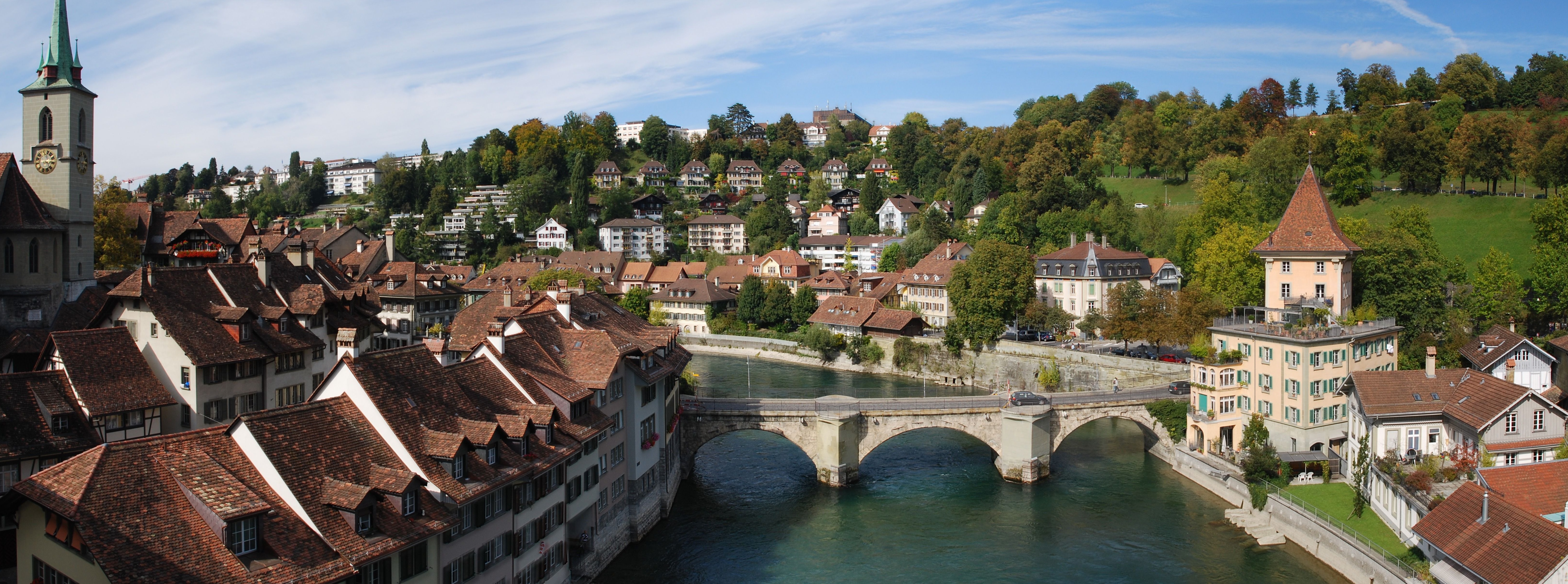
caption = The Untertorbrücke as seen from theNydeggbrücke
official_name =
carries = Two lanes and sidewalks
crosses =River Aar
locale =Berne ,Switzerland
maint =
id =
designer =
design = Arched lintel bridge
material = Natural stone (Sandstone ,tuff )
spans = 3 [All construction data are from Furrer, 155.]
pierswater = 2
mainspan = m to ft|15.1
length = m to ft|52.5
width = m to ft|7.5
height = m to ft|8.1
load =
clearance = m to ft|4.3
below =
traffic =
begin = 1461
complete = 1489
open =
closed =
toll =
map_cue =
map_
map_text =
map_width =
coordinates = coord|46|56|57.96|N|7|27|30.47|E|region:CH-BE_type:landmark|display=inline,title
lat =
long = The Untertorbrücke (German: Lower Gate Bridge) is a stonearch bridge that spans theriver Aar at the easternmost point of the "Enge" peninsula in the city ofBerne ,Switzerland , connecting the "Mattequartier " in the Old City to the "Schosshalde " neighbourhood. Built in its current form in 1461–89, it is the oldest of Berne's Aar bridges, and was the city's only bridge up until the middle of the 19th century.History
Wooden bridge, 1255
The need for a river crossing became urgent soon after the founding of Berne in 1191. [Furrer, 7.] The young city-state's first attempt at building a wooden bridge over the Aar triggered a war with Count
Hartmann of the powerful House ofKyburg that controlled the territory east of the Aar. [Furrer, 7; Hofer, 195.] Thanks to a peace mediated bySavoy , the first "Untertorbrücke" could be completed in 1256. [Furrer, 7; Hofer, 196.] In 1288, it survived a heavy attack during KingRudolph of Habsburg 's second siege of Berne. [Hofer, 196.]The bridge was built from
oak wood and is believed to have been at least partially covered. [Furrer, 7.] It was protected by a fortified tower to the east, carried a guard house in its center and may also have been built over with other houses or shacks. [Furrer, 7; Hofer, 197.]Construction of the stone bridge, 1461
A 1460 flood of the Aar caused severe damage to the bridge, and the city government decided to rebuild it in stone, [Furrer, 7; Hofer, 197.] requesting the services of a work master from
Zürich who had then recently completed a bridge over the riverLimmat in Baden. [Furrer, 7; Hofer, 198.] The piers appear to have been complete and the bridge largely usable by March 1467, when the bridge chapel was consecrated. [Furrer, 7; Hofer, 198.] The construction was then halted because of massive cost overruns and intermittent wars. It resumed in 1484–87 with the completion of the fortifications, the bridgehead drawbridge and the access roads. [Furrer, 7; Hofer, 199.]Up until the 1750s, the bridge's fortifications were repeatedly improved. The
parapet was strengthened with crenellated stone walls in 1517, and the northern parapet was expanded to a coveredbattlement with a double layer ofembrasure s in 1625–30. [Furrer, 8; Hofer, 200–203.]Reshaping the bridge, 1757 and 1818
In the
18th century , the medieval fortifications of the Untertorbrücke had lost their military value and increasingly became an obstacle to traffic. In 1757, the bridge was thoroughly renovated and a competition was held for a remodeling of the bridge and its surroundings. [Furrer, 10.] The city councils, however, rejected all the fanciful plans that were submitted and settled on a cheaper option: all fortifications, including battlements and pillar gates, were removed and new decorative gates were built at the bridgeheads, including abaroque triumphal arch at the eastern end. [Furrer, 10.]From 1818 on, more changes were made to the bridge's superstructure. The sandstone parapets were replaced with iron railings, the inner gate (now isolated) was removed and the eastern moat was filled with earth, obviating the outer drawbridge. [Furrer, 10; Hofer, 208.] The last substantial change to the bridge's appearance was made in 1864, when the eastern gate was pulled down because it inconvenienced the residents of the medieval guard tower, the "Felsenburg", which had since been converted for residential purposes. [Furrer, 10; Hofer, 209.]
Current state
In its current form, the bridge is reduced to the medieval construction core, with no traces of the once extensive system of fortifications or imposing baroque gates remaining. [Furrer, 11; Hofer, 209.] The two great piers, whose unequal strength recalls the stronger build of the former eastern pier gate, are built of
sandstone and are faced bygranite slabs from the 1820s. [Furrer, 11; Hofer, 209.] At the eastern bridgehead, the two-lane road bends to the south where it once passed beneath the former guard tower. The stones of the three slendertuff arches date back to the construction period, while theNeo-gothic wrought-iron railing was installed in 1819. [Furrer, 11; Hofer, 210.]The state of the superstructure largely reflects that of the early 19th century. [Furrer, 11; Hofer, 210.] The cobbled roadbed, which carries two lanes amenable to motor traffic as well as sidewalks, was replaced in the bridge's last thorough renovation in 1979–81. [Caviezel, 163.]
References
*Citation
last = Furrer
first = Bernhard
publication-date = 1984
title = Übergänge: Berner Aarebrücken, Geschichte und Gegenwart
publication-place = Berne
publisher = Benteli
isbn = 3-7165-0492-0
*Citation
last = Hofer
first = Paul
year = 1959
series = Kunstdenkmäler des Kantons Bern
volume = 1
title = Die Stadt Bern.
publication-place = Basel
publisher = Gesellschaft für Schweizerische Kunstgeschichte / Verlag Birkhäuser
pages = 193–224
url = http://digibiblio.unibe.ch/digibern/Chopin/Engine/Systematik/viewer.asp?KatalogID=1&ImgNum=203
isbn = 3-90613-113-0
*Citation
last1 = Caviezel
first1 = Zita
last2 = Herzog
first2 = Georges
last3 = Keller
first3 = Jürg A.
year = 2006
title = Basel-Landschaft, Basel-Stadt, Bern, Solothurn
edition = 1st
volume = 3
series = Kunstführer durch die Schweiz
publication-place = Berne
publisher =Gesellschaft für Schweizerische Kunstgeschichte
page = 248
isbn = 3-906131-97-1Footnotes
Wikimedia Foundation. 2010.