Háromszék

Háromszék

Infobox Former Subdivision
native_name =
conventional_long_name = Háromszék County
common_name = Háromszék
subdivision = County
nation = the Kingdom of Hungary
p1 =
s1 =
year_start = 1876
event_end = Treaty of Trianon
year_end = 1920
date_end = June 4


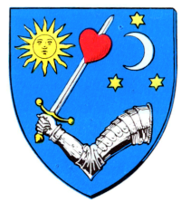
capital = Sepsiszentgyörgy
stat_area1 = 3889
stat_pop1 = 148100
stat_year1 = 1910
today = Romania
footnotes = Sfântu Gheorghe is the current name of the capital.

Háromszék (English translation:"Three Chairs"; Romanian: "Trei Scaune") is the name of a historic administrative county (
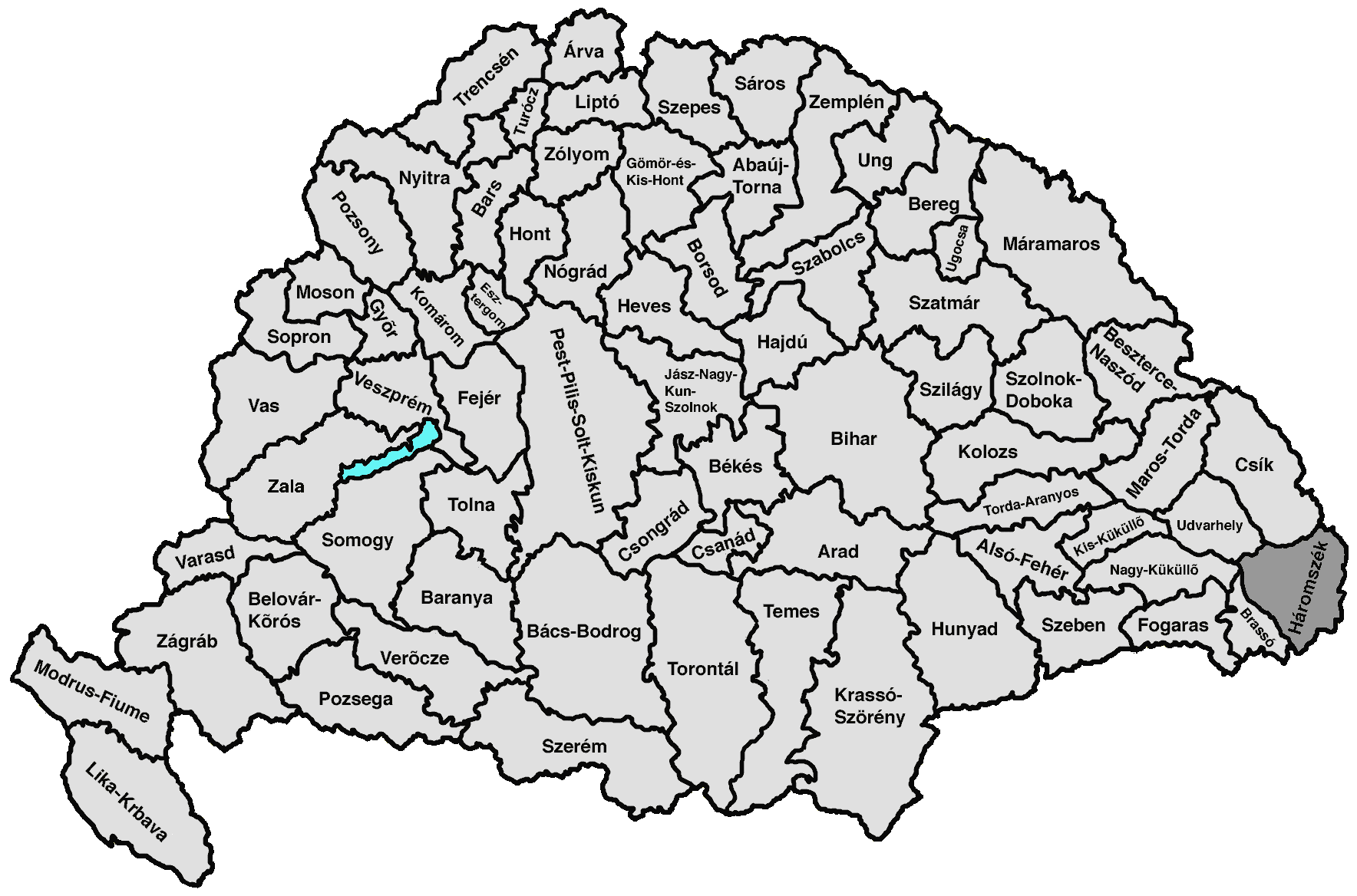
comitatus) of the Kingdom of Hungary. Its territory is presently in central Romania (south-eastern Transylvania). The capital of the county was Sepsiszentgyörgy (now Sfântu Gheorghe).

Geography

Háromszék county shared borders with Romania and the Hungarian counties Csík, Udvarhely, Nagy-Küküllő and Brassó. The river Olt flows through the county. The Carpathian Mountains form its southern and eastern border. Its area was 3889 km² around 1910.

History

Háromszék means "three seats". The Háromszék region was a combination of three settlements (seats) of the Székely: Kézdiszék, Orbaiszék and Sepsiszék. Háromszék county was formed in 1876, when the administrative structure of Transylvania was changed. In 1918 (confirmed by the Treaty of Trianon 1920), the county became part of Romania except Hungarian occupation between 1940-1944 during World War II. Its territory lies in the present Romanian counties Covasna and Braşov (a small part in the south).

Demographics

In 1891, county had a population of 130,008 people. Population by language:
* Hungarian: 110,799 people (86%)
* Romanian: 17,360 people (13,4%)
* German: 511 people (0,4%)
* Slovak: 251 people (0,2%)

ubdivisions

In the early 20th century, the subdivisions of Háromszék county were:

External links

* [http://lazarus.elte.hu/hun/maps/1910/gonczy/haromszek.htm Map of the county]


Wikimedia Foundation. 2010.

Игры ⚽ Поможем написать реферат

Look at other dictionaries:

  • Háromszék — (spr. ßēk, »Drei Stühle«), ungar. Komitat im südöstlichen Teil Siebenbürgens, grenzt an die Komitate Kronstadt, Udvarhely, Csik und an Rumänien, umfaßt 3556 qkm (64,6 QM.) mit (1901) 137,261 maygarischen (Szekler) und rumän. Einwohnern (meist… …   Meyers Großes Konversations-Lexikon

  • Háromszék — (spr. háhromßehk), Komitat im südöstl. Siebenbürgen, 3893 qkm, (1900) 137.261 E.; Hochebene mit dichten Waldungen, Ackerbau, Viehzucht: Mineralquellen. Hauptstadt Sepsiszentgyörgy …   Kleines Konversations-Lexikon

  • Háromszék — Komitat Háromszék (1910) Verwaltungssitz: Sepsiszentgyörgy (heute rumänisch Sfântu Gheorghe) …   Deutsch Wikipedia

  • Háromszék County — Háromszék vármegye Comitatul Trei Scaune Komitat Háromszék County of the Kingdom of Hungary …   Wikipedia

  • Komitat Háromszék — (1910) Verwaltungssitz: Sepsiszentgyörgy Fläche …   Deutsch Wikipedia

  • Comitat de Háromszék — Les armes du comitat de Háromszék comitat de Háromszék …   Wikipédia en Français

  • History of the Székely people — OriginsMythsAt the end of the 13th century, in a chronicle called Gesta Hungarorum, the notary of Hungarian King Béla explained his beliefs about the conquest of Hungary about 280 years earlier. According to this chronicle, the Hungarians and… …   Wikipedia

  • Liste historischer Komitate Ungarns — Nachfolgend sind die historischen Komitate Ungarns ab 1867 aufgeführt. Inhaltsverzeichnis 1 Ungarische Komitate von 1867 bis 1918 1.1 Magyarország – Ungarn (63 Komitate: Stand 1910) 1.2 „Corpus separatum“ – Stadt Fiume mit Gebiet 2 Kroatische… …   Deutsch Wikipedia

  • Székely Land — ( hu. Székelyföld; la. Terra Siculorum; ro. Ţinutul Secuiesc) refers to the territories inhabited by the Székely, a Hungarian minority living in the centre of Romania. They live in the valleys and hills of the Eastern Carpathian Mountains,… …   Wikipedia

  • Comandau — Comandău Kommandó Hilfe zu Wappen …   Deutsch Wikipedia

Share the article and excerpts

Direct link
Do a right-click on the link above
and select “Copy Link”