- Cascata delle Marmore
-
Cascata delle Marmore 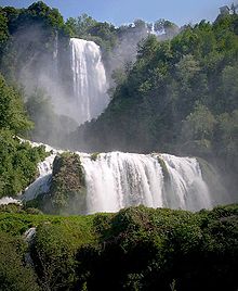
The Cascata delle Marmore in full operation, seen from Vasi square, along the Valnerina road.Location Umbria, Italy Type Tiered Total height 165 m Number of drops 3 Longest drop 83 m The Cascata delle Marmore (Marmore's Falls) is a man-made waterfall created by the ancient Romans. Its total height is 165 m (541 feet), making it one of the tallest in Europe and the tallest man-made waterfall in the world. Of its 3 sections, the top one is the tallest, at 83 m (272 feet).
It is located 7.7 km from Terni, a provincial capital of the Italian region of Umbria.
Its source is a portion of the waters of the river Velino (the rest of the river flows into a hydroelectric power plant), after flowing through Piediluco lake near the community of Marmore. It pours into the valley below formed by the river Nera. Its flow is turned on and off according to a published schedule, to satisfy the needs of tourists and the power company alike. Tourists try to be there the moment the gates are opened to see the powerful rush of water.
Contents
The falls today
Most of the time, the water in the canals above the falls is diverted to a hydroelectric power plant, so the flow in the falls themselves is reduced to the level of a creek. Piediluco Lake, above the falls, is used as a reservoir for the power plant. The Galleto power plant, built in 1929, is architecturally interesting. Its capacity is about 530 MW. To control the operation of the power plant, and to satisfy tourists, the fall is turned on according to a set schedule, achieving a spectacular effect at full flow. An alarm is sounded first, then the gates are opened, and in a few minutes the small creek is transformed into a full-sized river rushing into the void below.
Normally, the fall is turned on between noon and 1:00 PM and again between 4:00 and 5:00 PM every day, with additional times on holidays. An entrance fee is charged to visit the falls and the surrounding area.
A path along the falls allows the visitor to hike up to the top of the falls. Along the way, a tunnel leads to an observatory just next to the falls, where a visitor is guaranteed to get soaked. A safer observatory near the top affords a grandiose view of the falls and of the Nera valley below.
History
The Velino river flows through the highlands that surround the city of Rieti. In ancient times, it fed a wetland that was thought to bring illness (probably malaria). To remove that threat to the city of Rieti, in 271 BC, the Roman consul Manlius Curius Dentatus ordered the construction of a canal (the Curiano Trench) to divert the stagnant waters into the natural cliff at Marmore. From there, the water fell into the Nera river below. However, that solution created a different problem: when the Velino river was in flood stage, its water flowed through the Nera toward the city of Terni, threatening its population. The issue was so contentious between the two cities that the Roman Senate was forced to address it in 54 BC. Cicero represented Terni, and Aulus Pompeius represented Rieti. The Senate did nothing about the problem, and things remained the same for centuries.
Lack of maintenance in the canal resulted in a decrease in the flow, until eventually the wetland began to reappear. In 1422, Pope Gregory XII ordered the construction of a new canal to restore the original flow (the Gregorian Trench or Rieti Trench).
In 1545, Pope Paul III ordered that a new canal be built (the Pauline Trench). The plan was to expand the Curian Trench and to build a regulating valve to control the flow. Upon its completion some 50 years later (in 1598), Pope Clement VIII inaugurated the new work, and named it after himself: the Clementine Trench.
In the following two centuries, the presence of the canal was problematic for the countryside in the valley below, as the Nera often flooded it. In 1787, Pope Pius VI ordered architect Andrea Vici to modify the leaps below the falls, giving the falls its present look and finally resolving the majority of the problems.
In 1896, the newly formed steel mills in Terni began using the water flow in the Curiano Trench to power their operation. In the following years, engineers began using the water flow to generate electricity.
See also
External links
- Official website for the falls, with schedule and admission prices (Italian) (English)
Coordinates: 42°33′09″N 12°42′54″E / 42.552448°N 12.714958°E
Categories:- Terni
- Waterfalls of Umbria

Wikimedia Foundation. 2010.