- Langeland
Geobox Settlement
name = Langeland
native_name =
other_name =
other_name1 =
category = Island
image_size = 290px
image_caption =
flag_size =
symbol =
symbol_size = 90px
country = DEN | state=
region =Region Syddanmark
district =Langeland municipality
district_type = Municipality | district_label=
part_type = | part_count =
part = | part1 =
area = 285
area_round = 0
location =
lat_d = 54 | lat_m = 56 | lat_s = 0 | lat_NS= N
long_d= 10 | long_m= 47 | long_s= 0 | long_EW= E
elevation =
population_as_of = 2006
population = 13.881 | population_density=49
established_type =
established =
established1_type =
mayor =
timezone = CET
utc_offset = +1
timezone_DST = CEST
utc_offset_DST= +2
postal_code = | postal_code_type = Postal codes
area_code = | area_code_type=
free_type = | free=
free1_type = | free1=

map_size=
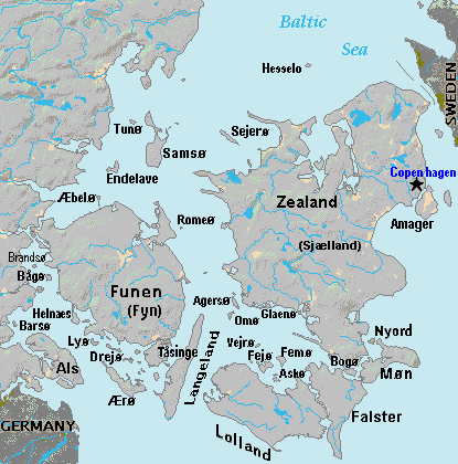
map_caption = Langeland Island (lower center) in Denmark
map_locator =
map_locator_x =
map_locator_y =
website =Langeland is a Danish
island located between theGreat Belt andBay of Kiel .The island measures 285 km² (c. 110 square miles), and has a population of roughly 15,000. The island produces grain and is known as a recreational area. A bridge connects it toTåsinge via Siø - a small island with a population of approx. 20 - and the main island ofFunen (to the northwest). Also there are connections by car ferry to the islands ofLolland ,Ærø and Strynø.The famous physicist and chemist
Hans Christian Ørsted was born inRudkøbing - the largest city on Langeland.Administratively, the island is also a
municipality ("Langeland municipality ").Additionally, Langeland is also a small town in southern
Norway (http://maps.google.com/maps?um=1&tab=wl&hl=en&q=langeland%20norway click here] ). Several families from that town changed their surname in the 1800s to "Langeland."
Wikimedia Foundation. 2010.
