- Ogaden
-
This article is about the geographical area. For the Somali clan, see Ogaden (clan).
Ogaden
OgaadeenShaded relief map of Ethiopia, cropped and centered on the Ogaden area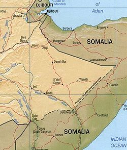
Region (non-administrative) Ogaden Area – Total 179,252 km2 (69,209.6 sq mi) Population (2005)[citation needed] – Total 2,329,000 – Density 13/km2 (33.7/sq mi) ISO 3166 code ET-SO Ogaden (pronounced and often spelled Ogadēn; Somali: Ogaadeen, Amharic: ኦጋዴን?) is the name of a territory comprising the southeastern portion of the Somali Regional State in Ethiopia. The inhabitants are predominantly ethnic Somali and Muslim. The title "Somali Galbeed", which means "Western Somalia," is often preferred by Somali irredentists.
The region, which is around 200,000 square kilometres, borders Djibouti, Kenya, and Somalia.[1] Important towns include Jijiga (Jigjiga), Awbere, Feer Feer, Degehabur, Raaso, (Dhagaxbuur in Somali), Gode (Godey), Kebri Dahar (Qabridahare), Fiq, Shilavo (Shilaabo), Kelafo, Werder (Wardheer), and Denan.
The Ogaden is a plateau, with an elevation above sea level that ranges from 1,500 meters in the northwest, falling to about 300 meters along the southern limits and the Wabi Shebelle valley. The areas with altitudes between 1,400 and 1,600 meters are characterized as semi-arid; receiving as much as 500–600 mm of rainfall annually. More typical of the Ogaden is an average annual rainfall of 350 mm and less. The landscape consists of dense shrubland, bush grassland and bare hills.[2] In more recent years, the Ogaden has suffered from increasingly erratic rainfall patterns, which has led to an increasing frequency of major droughts: in 1984-85; 1994; and most recently in 1999-2000, during which pastoralists claim to have lost 70-90 percent of their cattle.[3]
Contents
History
 Map of Ethiopia highlighting the Somali Region.
There are few historical texts written about the people who lived in what is known today as the "Ogaden" region of Ethiopia. Ogaden was part of the Muslim Ifat Sultanate in the 13th and beginning of the 14th centuries AD. The borders of the sultanate extended to the Shewa - Addis Ababa area of Ethiopia. The region developed its own Adal kingdom from late 14th to the last quarter of the 19th century. There was an ongoing conflict between the Adal kingdom and the Christian Kingdom of Abyssinia throughout this time. Both Abyssinia and the Adal kingdom are mostly located in present day Ethiopia. During the first half of the 16th century, most of Abyssinian territory was conquered and came under the rule of Adal, when Ahmad ibn Ibrihim al-Ghazi, the leader of the Somali-dominated Adal's Army, took control.[4]
During the last quarter of the 19th century, the region was conquered by Menelik II of Abyssinia and Ethiopia solidified their occupation by treaties in 1897.[5]
I.M. Lewis argues a subtly different interpretation of this treaty, emphasizing that "the lost lands in the Haud which were excised from the Protectorate [i.e. British Somaliland] were not, however ceded to Ethiopia".[6] In practice, Ethiopia exerted little administrative control east of Jijiga until 1934 when an Anglo-Ethiopian boundary commission attempted to demarcate the treaty boundary. This boundary is still disputed.[7]
The Italians annexed the region to Italian Somaliland in 1936 after their conquest of Ethiopia. Following their conquest of Italian East Africa, the British sought to let the Ogaden be unified with British Somaliland and the former Italian Somaliland, to realize Greater Somalia which was supported by many Ogaden Somalis.[8] Ethiopia unsuccessfully pleaded before the London Conference of the Allied Powers to gain the Ogaden and Eritrea in 1945, but their persistent negotiations and influence from the USA eventually persuaded the British in 1948 to abandon all of the Ogaden except for the Haud, and a corridor called the Reserved Area stretching from the Haud to French Somaliland (modern Djibouti). The British returned these last parts to Ethiopia in 1954.[9]
In the late 1970s, internal unrest in the Ogaden resumed. The Western Somali Liberation Front, spurred by Muktal Dahir, used guerilla tactics to resist Ethiopian rule. Ethiopia and Somalia fought the Ogaden War over control of this region and its peoples.
In 2007, the Ethiopian Army launched a military crackdown in Ogaden after Ogaden rebels killed dozens of civilian staff workers and guards at an Ethiopian Oil field.[10] The main rebel group is the Ogaden National Liberation Front under its Chairman Mohamed O. Osman, which is fighting against the Ethiopian government. Some Somalis who inhabit Ogaden claim that Ethiopian military kill civilians, destroy the livelihood of many of the ethnic Somalis and commit crimes against the nomads in the region. However, a Testimony before the United States House of Representatives Committee on Foreign Affairs revealed massive brutality and killings by the ONLF rebels, which the Ethiopian government labels "terrorists." [11] The extent of this war can't be established due to a media blockade in the Ogaden region. Some international rights organizations have accused the Ethiopian regime of committing abuses and crimes that "violate laws of war,"[12] as a recent report by the Human Rights Watch indicates. Other reports showed further abuses, bombings and murders carried out by the ONLF rebel group.[13][14] [15]
Ecology
This locale has been a historic habitat for the endangered African Wild Dog, Lycaon pictus;[16] however, this canid is thought by some to have been extirpated from Ogaden.
See also
Notes
- ^ Gebru Tareke, "The Ethiopia-Somalia War of 1977 Revisited," in Board of Trustees, Boston University, The International Journal of African Historical Studies. Boston University African Studies Center, 2000, p. 636.
- ^ Ayele Gebre-Mariam, The Critical Issue of Land Ownership, Working Paper No. 2 (Bern: NCCR North-South, 2005), p. 12 (accessed 19 January 2009)
- ^ CHF International, Grassroots Conflict Assessment in the Somali Region (Aug. 2006), p. 12 (accessed 12 December 2008)
- ^ A History of the Ogaden (Western Somali) Struggle for Self - Determination, first edition (London:Mohamed Abdi, 2007), pp. 4-12.
- ^ Bahru Zewde, A History of Modern Ethiopia (London: James Currey, 1991), p. 113.
- ^ I.M. Lewis, A Modern History of the Somali, fourth edition (Oxford: James Currey, 2002),p. 59
- ^ Lewis, Modern History, p. 61
- ^ Bahru Zewde, History p. 180.
- ^ Bahru Zewde, History, p. 181.
- ^ Ethiopian Rebels Kill 70 at Chinese-Run Oil Field
- ^ US Committee on Foreign Affairs on Ethiopia
- ^ Ethiopia: Crackdown in East Punishes Civilians (Human Rights Watch, 4-7-2007)
- ^ Ethiopia Ogaden rebels blast report on killing civilians
- ^ ONLF rebels accused of killing civilians in southern Ethiopia
- ^ Connors, Will (2007-09-05). "Why We Don't Hear About the Conflict in the Ogaden: When an American reporter started digging, he was forced out of Ethiopia.". Slate. http://www.slate.com/id/2173264/.
- ^ C. Michael Hogan. 2009. Painted Hunting Dog: Lycaon pictus, GlobalTwitcher.com, ed. N. Stromberg
External links
Coordinates: 7°17′00″N 44°18′00″E / 7.28333334333°N 44.30000001°E
Wikimedia Foundation. 2010.