- Washabaugh County, South Dakota
Infobox Settlement
official_name = Washabaugh County, South Dakota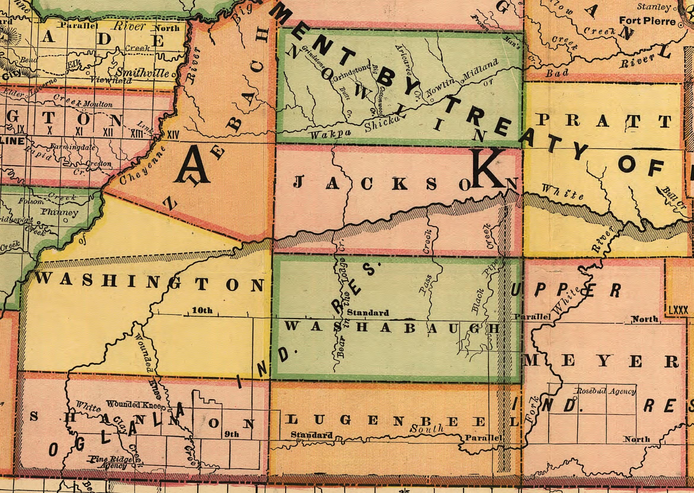
mapsize = 300px
map_caption = Map of Washabaugh County showing its boundaries in 1892
mapsize1 =
map_caption1 =
image_dot_
dot_mapsize =
dot_map_caption =
dot_x =
dot_y =
established_title = Established
established_date =March 9 ,1883
established_title2 = Dissolved
established_date2 =January 1 ,1983
area_magnitude =
unit_pref = Imperial
area_footnotes = [cite book | last= United States Census Bureau |url=http://www2.census.gov/prod2/decennial/documents/06229686v38-43ch3.pdf |title= 1970 Census of Population: South Dakota |volume=Volume 1, Part 43 |authorlink = United States Census Bureau |publisher=Government Printing Office |date= 1973 |pages=15]
area_total_km2 =
area_land_km2 =
area_water_km2 =
area_total_sq_mi = 1061
area_land_sq_mi =
area_water_sq_mi =
area_water_percent =
area_urban_km2 =
area_urban_sq_mi =
area_metro_km2 =
area_metro_sq_mi =
area_blank1_title =
area_blank1_km2 =
area_blank1_sq_mi =
population_as_of = 1970
population_total = 1389
population_density_km2 =
population_density_sq_mi = 1.3
population_metro =
population_density_metro_km2 =
population_density_metro_sq_mi =
population_urban =
population_density_urban_km2 =
population_density_urban_sq_mi =
population_blank1_title =
population_blank1 =
population_density_blank1_km2 =
population_density_blank1_sq_mi =
latd = 43 |latm = 33 |lats = 10 |latNS = N
longd = 101 |longm = 41|longs = 12|longEW = W
elevation_footnotes =
elevation_m =
elevation_ft = 2713
postal_code_type =
postal_code =
blank_name = GNIS feature ID
blank_info = 1265805 [cite gnis|1265805|Washabaugh County, South Dakota]Washabaugh County is a former county in
South Dakota . The county was named afterFrank Washabaugh , a prominent South Dakota politician. [cite book|last= Gannett|first= Henry|title= The Origin of Certain Place Names in the United States|date = 1905|edition= Second Edition|publisher=Government Printing Office |location=Washington, D.C. |pages= 316] [Google books|9V1IAAAAMAAJ|Place Names in the United States]History
First established in 1883 as a county in
Dakota Territory from a part of Lugenbeel County, it became a county in the new state of South Dakota in 1889.cite web |url=http://historical-county.newberry.org/Website/South_Dakota/documents/DAKs_Individual_County_Chronologies.htm |title= Dakota Territory, South Dakota, and North Dakota: Individual County Chronologies |accessdate=2008-07-18 |work= Dakota Territory Atlas of Historical County Boundaries |author = John H. Long, Editor |publisher= Newberry Library |date= 2006 ] Washabaugh remained an unorganized county, attached to various other counties for judicial purposes, until it merged with Jackson County in 1983.Geography
The county encompased the northeast corner of the
Pine Ridge Indian Reservation including the community of Wanblee. The eastern portion of the county was within the theRosebud Indian Reservation until 1911, when that part was annexed into the newly created Mellette County.cite book | last= United States Census Bureau |url=http://www2.census.gov/prod2/decennial/documents/06229686v38-43ch3.pdf |title= Fourteenth Census of the United States. State Compendium, South Dakota. |authorlink = United States Census Bureau |publisher=Government Printing Office |date= 1921 |pages=12, 25] By 1914, Washabaugh County's boundaries were expanded to include a portion of Washington County to the west and all of Jackson County south of the White River. [ [http://freepages.genealogy.rootsweb.com/~shastaca/maps/SD/Ben-Haa-Jac-Mel-Tod-Wasa.html 1914 Map of Washabaugh County] ]Demographics
As an unorganized county lying entirely within two
American Indian reservations, Washabaugh did not report separate population totals during the 1890, 1900, and 1910 censuses. Instead, population was included in the total population counts for the Pine Ridge and Rosebud reservations.cite book |last= United States Census Bureau |url=http://www2.census.gov/prod2/decennial/documents/36894832v3ch5.pdf |title= THIRTEENTH CENSUS OF THE UNITED STATES. | volume = Volume 3, Population |authorlink = United States Census Bureau |publisher=Government Printing Office |date= 1913 |pages=689] The county started reporting separate population counts with the 1920 Census.References
Wikimedia Foundation. 2010.