- Phare de la Vieille
Infobox_Lighthouse
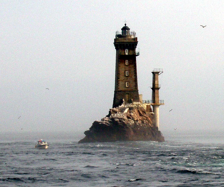
caption = Phare de la Vieille
location =Raz de Sein ,Finistère ,Brittany ,France .
coordinates = coord|48|2|30|N|4|45|24|W|type:landmark
yearbuilt = 1882
yearlit = 1887
automated = 1995
yeardeactivated =
foundation =
construction =
shape =
marking =
height = 25.9 m
elevation = 33.9 m
lens = 4/5 horizon lens, 50 cm focal, ∅ 3 m
currentlens =
intensity = 250 W halogen lamp
range = convert|18|nmi|km|0
characteristic = Fixed light, white-red-green cycle every 12 seconds.Phare de la Vieille (Vieille lighthouse) is a
lighthouse in the département ofFinistère on the northwest coast ofFrance . Built between 1882 and 1887 on the rock known as "la Gorlebella" (Breton for "the farthest rock"), it illuminates and improves the safety of the strait "Raz de Sein ", across from the companion lighthouseTourelle de la Plate . It is found in the commune ofPlogoff and belongs to the state of France.The so-called "hell" of this lighthouse is due to its remote position in rough seas. Furthermore, it has a rich past: between the first feasibility studies and its first lighting, nearly ten years were necessary. In 1995 it became the second to last French lighthouse to be automated, a process delayed due to the
lighthouse keeper s on the site refusing in protest to carry out the task.Construction and initial operation
On
30 November 1861 , the French _fr.Commission des phares (lighthouse commission) recommended in favour of construction a "3rd order" lighthouse on the rock, and engineers were invited to carry out a pilot study in 1862. This pilot study was postponed, however, due to financial difficulties as well as the construction of other projects such as theAr Men .Ten years later, the project was resumed, but the director of the Service of Lighthouses was forced to admit on
1 June 1872 that "the construction of a lighthouse on the Vieille will be postponed until some later date, and the difficulties encountered in embarking on the rock could even see it abandoned altogether". The _fr. Commission des phares met on14 January 1873 , agreeing that "the exceptional difficulties that this public work presents compels us to postpone the project, particularly due to the presence of similar works being undertaken on the rock of Ar Men.In the meantime, the lighthouse "
Phare de Tévennec " and that of Raz, lit in 1874, partially compensate for the delay.The construction of the lighthouse was begun after a series of feasibility studies.
In 1879, the first of five landings at the rock was carried out, during which the rock, the pattern of
marine current s and the ease of docking at the site were examined. Fishermen from theIle de Sein manage with difficulty to establish the first mooring points. Six cubic metres of stonework were built for the base, with the help of stone masons who had already worked on the lighthouse of Ar Men. This work enables the rock to be boarded from the northeast.The next year, in 1880, a dozen or so more landings were carried out. Mooring rings were implanted, which enabled the base of a stone foundation to be established. This latter would then be used as a landing platform for building materials. This foundation was built out of 37 cubic metres of stone work.
The ministry of public works announced on
29 January 1881 that "from information gathered and results obtained during the two phases of construction, it is clear that a lighthouse can be established on the rock of Vieille, with the amount to be spent in alignment with the services required." A credit of 100,000 was approved in April 1882. The date of the end of the works, 1887, is inscribed on the tower.Although the works had been given the go-ahead, construction proved difficult. In this part of the sea, violent currents surround the rock of Gorlebella almost permanently, due to its position, laid out in the direction of the currents. The few sheltered locations are accessible only for short periods of time.
To the south the water is shallow. To the east and west, mooring is not possible due to marine currents ranging from six to fifteen knots. La Vieille can thus only be approached from the north side, and even then only during the three days either side of the quarter moon, if the sea is perfectly calm. If the sea is rough, swirling backwaters of 40 to 50 metres can be present.
Despite these many difficulties, the construction turned out to be less dangerous than that of Ar Men. This is because the rock juts 14 metres above high tide, and is 50 metres long and 20 metres wide. It was thus possible to construct a solid platform 20 meters by 10 metres wide.
The engineer Fenoux, in charge of building the lighthouse, had reckoned on construction work taking place five months of each year, counting on three days of good weather each quarter moon. This would lead to about 30 embarkations per year.
Construction
On
29 January 1881 , the minister of public works committed to the construction of the lighthouse after two years of studies. Thereafter, work began, based at Ile de Sein, where the cut stone was stored. The engineer in charge of overseeing the works, Probestau, actually moved onto the island himself. Since the construction of la Vieille was after that of Ar Men, the experience of the latter came into play. Thus, construction began each year on the first of May. Workmen were brought to the island in a little steam-powered boat towing alongboat full of construction materials as well as rowboats for the landing. Anchorages were set up to allow the steamboat and the longboats to moor.The first landings served to establish a small shelter made of stone in a hollow to the east of the rock. This shelter was used to house workers, their households and their tools, allowing the team to work on the preparation of the rock without interruption, whenever the weather allowed it.
On the 5 August 1882, the stone underpinnings of the lighthouse were begun. Three seasons later, the tower, its base and part of the interior were finished, in 1886. The rest of the interior work was finished in 1887. The stonework was reinforced with cement from
Boulogne-sur-Mer and from theIsle of Portland mixed with seawater for the base, but with freshwater for the rest of the building.The studies and the construction were directed from 1879 to 1885 by the engineer in chief of the " _fr. Ponts et Chaussées" (bridges and roads), named Fenoux. He was replaced from 1886 to 1887 by Considere. They were assisted by engineer Miniac for the whole period of the works.
The light at la Vieille was lit for the first time on
15 September 1887.Architecture and fittings
The architecture of the Vieille was designed to be aesthetically pleasing, and also chosen to minimise confusion with the nearby tower
Tévennec . Thus the lighthouse's shape is a squat quadrilateral, with slightcrenellation s. The tower is square and semi-cylindrical on the north face, broadening towards the base. The structure of the lighthouse was constructed from grey granite quarried from the Ile de Sein, while the tower and the corners of the building were built from coated cinder blocks of blue granite, fromKersanton .ignal history
Throughout its history, the Vieille's beam has shone several different ways:
*The first light was illuminated on 15 September 1887. It had white, red and green sectors, and had a 50 cm mirror. At the same time, the two lights of thePointe du Raz were put out.
*In 1898 the lighthouse was equipped with a 5-secondocculting light .
*In 1904 the burner was joined by a second, petrol burner.
*A foghorn was added on the 15 November 1913.
*In 1939 the signal was changed to 3 occultations (2 + 1) of white, red and green, then 5 white, red and green sectors, with a range of convert|18|nmi|km|0. This signal remains at present.The fuels used by the burners have also changed:
*Mineral oil, from 1887.
*Petrol vapour, from 1898.
*Electric, from 1995.Other forms of energy generation were used for the lighthouse wardens, but not for the light itself.
It was electrified in 1992, and automated on 14 November 1995. It was the second last French lighthouse to be automated, before
Kéréon .During
World War II , the lighthouse was evacuated on 21 January 1944, and reinstated on 1 June 1945.Life in the lighthouse
The lighthouse was normally permanently inhabited by two guardians, who were relieved regularly, but not at the same time. Two supply boats restocked it: the "
Blodwen " and "Velléda ".Properties
*Location: coord|48|2.5|N|4|45.4|W|scale:2000_region:FR
*Height: 26.90 m.
*Elevation above sea level: 33.90 m.
*Focal height: 23.90 m.
*Range: convert|18|nmi|km|0.
*Lights: Fixed light of 3 flashes of white, red, green each 12 seconds.
*Can be visited: no
*Lived in: no
*Optics: 4/5 horizon lens with a focal length of 50 cm and a diametre of 3 m.
*Lamp: 250 Whalogen lamp.
*Audible signal: ELAC-ELAU 2200 vibrator (2+1 sounds every 60 seconds)
*Date automated: 14 November 1994.
*Establishment of maritime signal: no 700/000.References
General sources
* « L'épopée des phares du Finistère », in "Chasse-Marée" no 53 http://www.chasse-maree.com/cgi-bin/chasse-maree.storefront/443411a40a070670273fd4ead8da0671/Product/View/02&2000&2053 ;
* « Gardiens de phares du Raz de Sein », in "Chasse-Marée" no 68 http://www.chasse-maree.com/cgi-bin/chasse-maree.storefront/443411a40a070670273fd4ead8da0671/Product/View/02&2000&2068 ;
* Jean Puloc'h, « Les phares de nos îles et leurs gardiens », in "L'Écho des Îles" (30 octobre 1993) http://www.glenan.fr/Textes/Echo_des_iles/931030_phares_iles_gardiens.htm ;
* Anne Lessard, « Le phare de La Vieille » sur le site Bretagne.com (juin 2005) http://www.bretagne.com/fr/patrimoine/patrimoine_maritime/phares/finistere/la_vieille ;
* [http://www.finistere.equipement.gouv.fr/rubrique.php3?id_rubrique=50 Section Sécurité maritime - Les Phares et Balises] on website of Direction Départementale de l'Équipement (DDE) du Finistère ;
* [http://www2.finistere.equipement.gouv.fr/spip29/mer/phares_balises/esm/Vieille.html « La Vieille »] on site of DDE of Finistère, (source for certain images) ;
* [http://www.inventaire.culture.gouv.fr/culture/inventai/presenta/visites/phares/phares-frame.htm Inventaire des phares]Notes
Wikimedia Foundation. 2010.