- Elek
Infobox Settlement
settlement_type =
subdivision_type = Country
subdivision_name = HUNlatd= |latm= |lats= |latNS=N
longd= |longm= |longs= |longEW=Epushpin_
pushpin_label_position =
pushpin_map_caption =
pushpin_mapsize =timezone=CET
utc_offset=+1
timezone_DST=CEST
utc_offset_DST=+2|official_name=Elek
picture=
subdivision_type1=County
subdivision_name1=Békés
area_total_km2=54.94
population_as_of=2001
population_total=5567
population_density_km2=101
postal_code_type=Postal code
postal_code=5742
area_code=66[
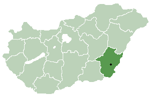 thumb|right|300px|Location_of_Békéscounty in
 Hungary ] Elek or Aletea (Romanian name) is atown inBékés county , in theSouthern Great Plain region of south-eastHungary .Geography
It covers an
area of 54.94km² and has apopulation of 5567 people (2002 ).History
* first mentioned 1232
* 1566-1696 Ottoman rule (Ottoman wars in Europe )
* 1724 settling of German colonists (predominantly fromFranconia )
* 1739 plague
* 1894 artesian aquifer
* 1920 Elek becomes border townTreaty of Trianon
* 1946 expulsion of German settlersTwin towns
*
Alerheim , Germany (1992)
*Gerolzhofen , Germany (1990)
*Grăniceri , Romania (1997)
*Laudenbach , Germany (1994)
*Leimen , Germany (1992)
*Sebiş , Romania (1992)
*Veľké Kapušany , Slovakia (1996)
Wikimedia Foundation. 2010.