Duck Island (Victoria)

Duck Island (Victoria)
Map of Swan Bay with Duck Island located between Edwards Point and Swan Island
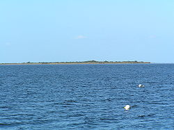
View of Duck Island from Swan Bay Jetty

Duck Island, a small barrier island, lies 1.5 km north of Swan Island and south of Edwards Point in the main entrance to Swan Bay from Port Phillip in southern Victoria, Australia. It is part of the Port Phillip Heads Marine National Park and the plants and animals on and around the island are protected, including the critically endangered Orange-bellied Parrot. The island is part of the Swan Bay and Port Phillip Bay Islands Important Bird Area, identified as such by BirdLife International.[1]

See also

  • Swan Bay

External links

Coordinates: 38°13′S 144°41′E / 38.217°S 144.683°E / -38.217; 144.683

References

  1. ^ "IBA: Swan Bay and Port Phillip Bay Islands". Birdata. Birds Australia. http://www.birdata.com.au/iba.vm. Retrieved 2011-10-26. 


Wikimedia Foundation. 2010.

Игры ⚽ Поможем решить контрольную работу

Look at other dictionaries:

  • Duck Island — ist der Name mehrerer Inseln in den Vereinigten Staaten: Duck Island (Alaska) Duck Island (Middlesex County, Connecticut) Duck Island (New Haven County, Connecticut) Duck Island (Georgia) Duck Island (Fulton County, Illinois) Duck Island (Lake… …   Deutsch Wikipedia

  • Duck Island — Contents 1 Locations 1.1 Australia 1.2 Europe 1.2.1 United Kingdom 1.3 North America …   Wikipedia

  • Swan Island (Victoria) — Infobox Australian Place | type = suburb name = Swan Island city = state = vic caption = Map of Swan Island lga = Borough of Queenscliffe postcode = 3225 est = pop = area = 1.40 propval = stategov = Bellarine fedgov = Corangamite near nw = Swan… …   Wikipedia

  • Duck Soup (1933 film) — This article is about the Marx Brothers film. For the Laurel and Hardy film, see Duck Soup (1927 film). For other uses, see Duck soup (disambiguation). Duck Soup Theatrical release poster Dire …   Wikipedia

  • Swan Bay (Victoria) — Infobox Ocean Ocean name = Swan Bay image Ocean = Swan bay map.png caption Ocean = Map of Swan Bay image bathymetry = caption bathymetry = coords = coord|38|13|S|144|39|E|type:bay region:AU VIC|display=inline,title type = Saline, Permanent,… …   Wikipedia

  • Edwards Point (Victoria) — Edwards Point (Coordinates: coord|38|13|S|144|41|E|type:point region:AU VIC|display=inline,title) is a 4 km long sand spit extending southwards between Swan Bay and Port Phillip Bay, at the eastern end of the Bellarine Peninsula, Victoria,… …   Wikipedia

  • St Leonards, Victoria — Infobox Australian Place | type = town name = St Leonards state = vic caption = Pier at St Leonards lga = City of Greater Geelong postcode = 3223 pop = 1621 (2006)Census 2006 AUS | id = SSC26661 | name = St Leonards (State Suburb) | accessdate =… …   Wikipedia

  • List of localities in Victoria (Australia) — Map of Local Government Areas in Victoria This is a list of locality names and populated place names in the state of Victoria, Australia, outside the Melbourne metropolitan area. It is organised by region from the south west of the state to the… …   Wikipedia

  • Norfolk Island — Territory of Norfolk Island Norfolk Island …   Wikipedia

  • Fantasy Island — This article is about the television series. For the amusement parks and other uses, see Fantasy Island (disambiguation) Fantasy Island Title card of the first installment of Fantasy Island. Format …   Wikipedia

Share the article and excerpts

Direct link
Do a right-click on the link above
and select “Copy Link”