- Pankyo
Infobox Korean settlement
context=north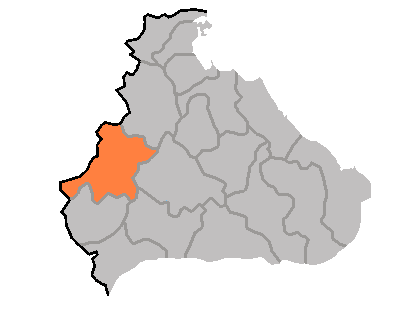
hangul=판교군
hanja=linktext|板|橋|郡
rr=Pan(-)gyo-gun
mr=P'an'gyo kun
divs=1 "ŭp", 22 "ri"
area_km2=623
pop=67000
popyear=1991
popnote=(est.)P'an'gyo is a "kun", or county, in Kangwŏn province,
North Korea .In December 1952, during the
Korean War , P'an'gyo was formed as a separate county from five "myŏn" (Nagyang, Pangjang, P'an'gyo, Ryongp'o, Sannae) of Ichŏn-gun and Yujin-myŏn of P'yŏnggang-gun. "Myŏn" were administrative units below county ("kun") level and are no longer used in North Korea.The land of P'an'gyo is predominantly mountainous, with the Ahobiryŏng Mountains ( _ko. 아호비령산맥; _ko. 阿虎飛嶺山脈) and Masingryŏng Mountains ( _ko. 마식령산맥; _ko. 馬息嶺山脈) both passing through the county. The highest point is Tongbaengnyŏnsan ( _ko. 동백년산). The county's chief stream is the Rimjin River. Approximately 88% of the county's area is forestland.
Agriculture is difficult due to the rugged terrain; however, crops are raised here including maize, potatoes, soybeans, wheat, and barley. Orcharding and livestock farming also play a role. In addition, mining is supported by local deposits of copper and nickel.
Pankyo is served by both road and rail, with the
Chongnyon-Ichon Line passing through the county.ee also
*
Geography of North Korea
*Administrative divisions of North Korea
*Kangwon (North Korea) External links
*baekgwa|empas_b=200567|empas_k=270900|naver=180402|nate=19543100|
Wikimedia Foundation. 2010.