Chari-Baguirmi Prefecture
- Chari-Baguirmi Prefecture
-
This article refers to one of the former prefectures of Chad. From 2002 the country was divided into 18 regions.
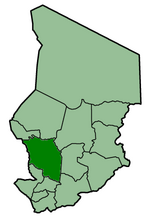
Chari-Baguirmi was one of the 14 prefectures of Chad. Located in the west of the country, Chari-Baguirmi covered an area of 82,910 square kilometers and had a population of 720,941 in 1993. Its capital was Ndjamena.
Wikimedia Foundation.
2010.
Look at other dictionaries:
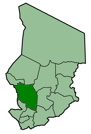
Chari-Baguirmi Region — Chari Baguirmi Region Map of Chad showing Chari Baguirmi. Country … Wikipedia
Chari-Baguirmi — may refer to: Chari Baguirmi Prefecture Chari Baguirmi Region This disambiguation page lists articles about distinct geographical locations with the same name. If an internal link led you here, you ma … Wikipedia
Chari-Baguirmi — Région du Chari Baguirmi Minṭaqâtu Šārī Bāqirmī (ar) منطقة شاري باقرمي (ar) Données clés Pays … Wikipédia en Français
Baguirmi language — language name=Baguirmi nativename=ɓarma states=Chad, Nigeria speakers=44,761 familycolor=Nilo Saharan fam2=Central Sudanic fam3=Western fam4=Bongo Bagirmi fam5=Sara Bagirmi fam6=Bagirmi group iso2=ssa|iso3=bmiBaguirmi (autonym: Unicode|ɓarma ) is … Wikipedia
Moyen-Chari Prefecture — This article refers to one of the former prefectures of Chad. From 2002 the country was divided into 18 regions. Moyen Chari was one of the 14 prefectures of Chad. Located in the south of the country, Moyen Chari covered an area of 45,180 square… … Wikipedia
Mayo-Kébbi Prefecture — This article refers to one of the former prefectures of Chad. From 2002 the country was divided into 18 regions. Mayo Kébbi was one of the 14 prefectures of Chad. Located in the southwest of the country, Mayo Kébbi covered an area of 30,105… … Wikipedia
Ouaddaï Prefecture — This article refers to one of the former prefectures of Chad. From 2002 the country was divided into 18 regions. Ouaddaï was one of the 14 prefectures of Chad. Located in the east of the country, Ouaddaï covered an area of 76,240 square… … Wikipedia
List of Chad-related topics — Chad articles=Chad related people*Ibrahim Abatcha *Abdullah I (Kanem Bornu king) *Abdelwahit About *Ahmad (Kanem Bornu king) *Ahmat Acyl *Mahamat Ali Adoum *Aissa Kili N guirmamaramama *Ali Gazi *Ali II of Bornu *Ahmad Allam Mi *Michel Arnaud… … Wikipedia
List of FIPS region codes (A-C) — This is a list of FIPS 10 4 region codes from A C, using a standardized name format, and cross linking to articles. AC: Antigua and Barbuda * AC01: Barbuda Dependency, Antigua and Barbuda * AC03: Saint George Parish, Antigua and Barbuda * AC04:… … Wikipedia
Agriculture in Chad — OverviewIn 1986 approximately 83% of the active population were farmers or herders. This sector of the economy accounted for almost half of GDP. With the exception of cotton, some small scale sugar production, and a portion of the peanut crop,… … Wikipedia