- North Auxiliary Airfield
-
"XNO" redirects here. For other uses, see XNO (disambiguation).
North Auxiliary Airfield 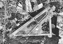
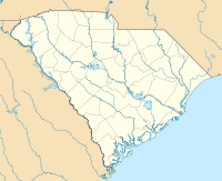
IATA: none – ICAO: KXNO – FAA LID: XNO Summary Airport type Military Owner U.S. Air Force Location North, South Carolina Elevation AMSL 321 ft / 98 m Coordinates Coordinates: 33°37′01″N 081°04′59″W / 33.61694°N 81.08306°W Website Runways Direction Length Surface ft m 6/24 10,000 3,048 Asphalt 5/23 3,500 1,067 Asphalt Sources: U.S. Air Force[1] and FAA[2] North Air Force Auxiliary Airfield (ICAO: KXNO, FAA LID: XNO) is a military airfield located 3 miles (4.8 km) east of North, a town in Orangeburg County, South Carolina, United States.[1][2]
It is owned by the U.S. Air Force and is used primarily for C-17 Globemaster III training by the 437th Airlift Wing and its Air Force Reserve "Associate" unit, the 315th Airlift Wing, at Charleston Air Force Base. Additional "bare base" operations are also conducted by the 20th Fighter Wing at Shaw Air Force Base and the 169th Fighter Wing at McEntire Air National Guard Station. Other units can utilize North with prior coordination with the 437 AW. The 437th Civil Engineering Squadron (437 CES) of the 437th Airlift Wing at Charleston AFB mainains a detachment to maintain and operate the airfield. The only permanently assigned personnel are 10 USAF firefighters and one civilian grounds keeper.[1]
Contents
Facilities
North Auxiliary Airfield covers an area of 2,400 acres (971 ha), of which 1,150 acres (465 ha) are undeveloped. It contains two asphalt paved runways: the main runway (6/24) measuring 10,000 x 150 ft (3,048 x 46 m) and an assault runway (5/23) measuring 3,500 x 90 ft (1,067 x 27 m).[1][2] The primary airstrip runs parallel to U.S. Route 178 but is screened from view from the road by trees.
History
 North Auxiliary AirfieldLocation of North Auxiliary Airfield, South Carolina
The land for North Army Airfield was bought between 1942 and 1945. The airfield was built by the United States Army Air Forces The original dirt runway was constructed in April 1943 and used by Hughes Aircraft Company for testing, as well as being a satellite airfield of Columbia Army Air Base, supporting B-25 Mitchell medium bomber training for Third Air Force III Air Support Command. Training was accomplished by 74th Station Complement Squadron which also maintained the facility.
After the war, a 12,000 ft runway and a 3,000 ft assault runway were built. North Airfield (Later North Auxiliary Airfield, Northfield Air Base), has been under the jurisdiction of Fort Jackson, Shaw AFB, the Department of Energy, and on 1 October 1979, Charleston AFB assumed real property jurisdiction, control, and accountability over North Field.
See also
References
 This article incorporates public domain material from websites or documents of the Air Force Historical Research Agency.
- ^ a b c d North Auxiliary Airfield at Charleston AFB web site
- ^ a b c FAA Airport Master Record for XNO (Form 5010 PDF), effective 2007-12-20
External links
- North Auxiliary Airfield at Town of North web site
- Resources for this U.S. military airport:
- AirNav airport information for KXNO
- NOAA/NWS latest weather observations
- SkyVector aeronautical chart for KXNO
 USAAF Third Air Force in World War II
Airfields Group Training Stations · Replacement Training Stations · Tactical Airfields
Units Commands II Air Support Command · III Air Support Command · III Bomber Command · III Fighter Command · III Reconnaissance Command · III Tactical Air CommandDivisions III Tactical Air DivisionWings 8th Fighter Wing · 9th Fighter Wing · 40th Bombardment WingGroups Air Commando 2nd Air Commando · 3rd Air CommandoBombardment 3rd Bombardment · 12th Bombardment · 17th Bombardment · 21st Bombardment · 29th Bombardment · 30th Bombardment Group · 38th Bombardment · 44th Bombardment · 46th Bombardment · 47th Bombardment · 85th Bombardment · 88th Bombardment · 90th Bombardment · 91st Bombardment · 92nd Bombardment · 93rd Bombardment · 94th Bombardment · 95th Bombardment · 97th Bombardment · 98th Bombardment · 99th Bombardment · 100th Bombardment · 309th Bombardment · 310th Bombardment · 312th Bombardment · 319th Bombardment · 320th Bombardment · 321st Bombardment · 322d Bombardment · 323d Bombardment · 335th Bombardment · 336th Bombardment · 340th Bombardment · 344th Bombardment · 345th Bombardment · 386th Bombardment · 387th Bombardment · 391st Bombardment · 394th Bombardment · 396th Bombardment · 397th Bombardment · 409th Bombardment · 410th Bombardment · 411th Bombardment · 416th Bombardment · 417th Bombardment · 418th Bombardment · 451st Bombardment · 454th Bombardment · 463rd Bombardment · 483rd Bombardment · 488th BombardmentFighter 20th Fighter · 31st Fighter · 49th Fighter · 50th Fighter · 53rd Fighter · 54th Fighter · 56th Fighter · 59th Fighter · 79th Fighter · 80th Fighter · 81st Fighter · 84th Fighter · 85th Fighter · 311th Fighter · 332nd Fighter · 337th Fighter · 338th Fighter · 339th Fighter · 361st Fighter · 369th Fighter · 372nd Fighter · 404th Fighter · 405th Fighter · 408th Fighter · 414th Fighter · 506th FighterFighter-Bomber 27th Fighter-Bomber · 48th Fighter-Bomber · 86th Fighter-Bomber · 406th Fighter-Bomber · 407th Fighter-BomberReconnaissance 2d Reconnaissance · 9th Reconnaissance · 10th Reconnaissance · 26th Reconnaissance · 65th Reconnaissance · 67th Reconnaissance · 68th Reconnaissance · 69th Reconnaissance · 70th Reconnaissance · 75th Reconnaissance · 77th Reconnaissance · 423d Reconnaissance · 424th Reconnaissance · 426th ReconnaissanceCategories:- 1942 establishments
- USAAF Third Air Force Group Training Stations
- Airports in South Carolina
- Bases of the United States Air Force
- Orangeburg County, South Carolina
- Airfields of the United States Army Air Forces in South Carolina


Wikimedia Foundation. 2010.