- Cobargo, New South Wales
-
Cobargo
New South Wales
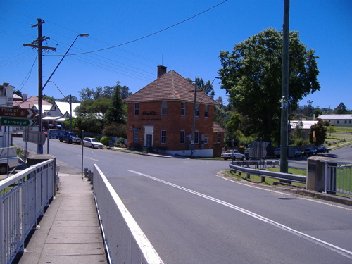
View of Cobargo from the Princes Highway bridge
 Cobargo
Population: 426 (2006 census)[1] Postcode: 2550 LGA: Bega Valley Shire State District: Bega Federal Division: Eden-Monaro Cobargo is a village in the south-east area of the state of New South Wales in Australia in Bega Valley Shire. In 2006, Cobargo had a population of 426 people.[1] It is 386 km south of Sydney on the Princes Highway between Narooma and Bega.
Cobargo's streetscape features many turn of the century buildings. It has developed in the last decade from a sleepy village into a popular tourist destination. Its attractions include olden-style stores, leather craftworks, potteries, an iron forge, award-winning winery, art galleries, tea rooms and antique shops. Wadbilliga National Park is 20 km west of Cobargo.
The name Cobargo may have originated from the local Indigenous Australian word 'cubago' which some sources claim was used to describe nearby Mount Gulaga.
Contents
History
 Art and craft galleries line the main street displaying locally produced works of pottery, leather and wood
The area was settled in the late 1820s when graziers moved stock into the district. William Duggan Tarlinton was the first white man to set foot in the district in 1829, seeking pasture for his cattle. He later settled in the district and became one of its prominent citizens. By the 1830s the Imlay brothers had substantial holdings. Cobargo was known as 'The Junction' in the late 1860s as it was located at the junction of the Narira and Bredbatoura Creeks. A school opened in 1871 and by that year the village had a post office, store, hotel, church and blacksmith shops. Development gained pace following the construction of a bridge over the Narira Creek in 1882 and improvement of the coast road in the 1880s. By the 1890s the town was large enough to sustain a local newspaper, the Cobargo Watch. A butter factory was established in 1901 and continued butter production until 1980. In 1903 a branch of the Bank of New South Wales was opened. The office built in 1917 on the corner of Bermagui Road operated until 1997.
The town was in decline for much of the twentieth century as transportation has made the larger centres more accessible, however like other nearby villages it has recently been revitalised as a tourist destination.
Location
Cobargo is on the Princes Highway 42 km north of Bega, the closest regional centre, and is 19.4 km from the coast at Bermagui[1]. It serves as the local village for the nearby localities of Coolagolite, Wandella, Yowrie and Dignam's creek. It is 386 km south of Sydney
Literary References
Writer Olga Masters based her collection of short stories A Long Time Dying on people and events in pre-war Cobargo. Olga Masters started her journalistic career on the Cobargo Chronicle at the age of 15 in 1934.
Events
 The post office and 'The Train' restaurant
- Cobargo hosts a country market on the fourth Saturday of every month in the grounds of the Cobargo RSL Hall.
- An annual folk music festival[2] is held here every February.
References
- ^ a b Australian Bureau of Statistics (25 October 2007). "Cobargo (L) (Urban Centre/Locality)". 2006 Census QuickStats. http://www.censusdata.abs.gov.au/ABSNavigation/prenav/LocationSearch?collection=Census&period=2006&areacode=UCL119400&producttype=QuickStats&breadcrumb=PL&action=401. Retrieved 28 June 2009.
External links
South Coast, New South Wales Cities: Townships: Basin View · Batehaven · Batemans Bay · Bawley Point · Bega · Bemboka · Bermagui · Berry · Bodalla · Boydtown · Broulee · Callala Bay · Candelo · Cobargo · Congo · Culburra Beach · Dalmeny · Eden · Greenwell Point · Huskisson · Hyams Beach · Kianga · Kioloa · Lake Conjola · Malua Bay · Manyana · Merimbula · Milton · Mogo · Mollymook · Moruya · Mystery Bay · Narooma · Nelligen · Nerrigundah · Pambula · Pambula Beach · Potato Point · Pyree · Rosedale · Sanctuary Point · South Durras · St Georges Basin · Tathra · Tilba · Towamba · Tura Beach · Tuross Head · Ulladulla · Vincentia · Wandandian · Wolumla · WonboynLocal Government Areas: National Parks: Ben Boyd · Bournda · Biamanga · Budawang · Clyde River · Conjola · Deua · Eurobodalla · Gulaga · Jerrawangala · Kooraban · Mimosa Rocks · Monga · Morton · Mount Imlay · Murramarang · South East Forest · WadbilligaCategories:- Towns in New South Wales
- Towns in the South Coast, New South Wales


Wikimedia Foundation. 2010.