Goose Island (Tasmania)

Goose Island (Tasmania)

Infobox_lighthouse
name=Goose Island
location=Bass Strait, Australia
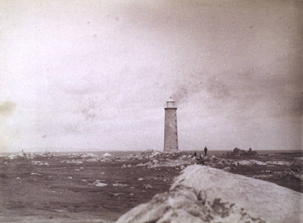


caption=
coordinates =
yearlit= 1846
yeardeactivated=
automated=
intensity= 60,000 cd
elevation= 36 m
range= convert|18|nmi|km|0
foundation=
construction= Rubblestone
shape=Conical
marking=White
height=30 m
lens=
currentlens =
intensity =
range =
characteristic = Fl. (2) 10 s
fogsignal =
admiralty =K3600
NGA =6644
ARLHS =AUS-064

Goose Island is an elongated granite island, with an area of 109 ha, in south-eastern Australia. It is part of Tasmania’s Badger Island Group, lying in eastern Bass Strait west of Flinders and Cape Barren Islands in the Furneaux Group. It has a lighthouse at the narrow southern end, and is a conservation area.

Lighthouse

The lighthouse is operated by the Australian Maritime Safety Authority and has been unmanned since 1931. It was originally constructed in 1846 with the use of convict labour. On 31 March 1857 the station was raided by pirates. From 1985 to 1990 a wind generator was used as a power source for the light, today the electricity is generated by solar panels.cite web|url=http://www.unc.edu/~rowlett/lighthouse/tas.htm|author=Rowlett, Russ|title=The Lighthouse Directory] The tower was built as a 30 metres tall rubblestone construction employing a Fresnel lens, which today is on display in Hobart at the Maritime Museum of Tasmania.cite web|url=http://www.unc.edu/~rowlett/lighthouse/tas.htm|author=Rowlett, Russ|title=The Lighthouse Directory] The focal plane of the lightsource is located 36 m above sea level, the light's characteristic is a double flash every ten seconds.

The island contains historic relics from the time when the lighthouse was manned, such as the remains of a wooden tramway used to supply the lighthouse, as well as the graves of light keepers, or members of their families, who died by drowning.cite web|url=http://www.lighthouse.net.au/lights/TAS/Goose%20Island/Goose%20Island.htm|author=Lighthouses of Australia Inc.|title=The Goose Island Lighthouse]

Flora and fauna

There are patches of the introduced noxious weed African Boxthorn at the wider northern end of the island. Otherwise the flora is dominated by mats of Aizoaceae succulents, "Poa" and "Stipa", with some "Acacia" and "Leptospermum" woody plants.

Recorded breeding seabird and wader species are Little Penguin, Short-tailed Shearwater, Pacific Gull, Silver Gull and Sooty Oystercatcher. Reptiles present include the Metallic Skink and Spotted Skink.Brothers, Nigel; Pemberton, David; Pryor, Helen; & Halley, Vanessa. (2001). "Tasmania’s Offshore Islands: seabirds and other natural features". Tasmanian Museum and Art Gallery: Hobart. ISBN 0-7246-4816-X]

References


Wikimedia Foundation. 2010.

Игры ⚽ Поможем сделать НИР

Look at other dictionaries:

  • Goose Island — may refer to:Places in Australia* Goose Island (South Australia), two islands ** Little Goose Island (South Australia) * Goose Island (Tasmania) ** Little Goose Island (Tasmania) ** Inner Little Goose Island * Goose Island (Western Australia),… …   Wikipedia

  • Little Goose Island (Tasmania) — Little Goose Island is a flat, round granite island, with an area of 3.6 ha, in south eastern Australia. It is part of Tasmania’s Badger Island Group, lying in eastern Bass Strait next to Goose and Inner Little Goose Islands, west of Flinders and …   Wikipedia

  • Passage Island (Tasmania) — Passage Island (Tasmania)Passage Island is a granite and dolerite island, with an area of 253 ha, in south eastern Australia. It is part of Tasmania’s Passage Island Group, lying in eastern Bass Strait south of Cape Barren Island in the Furneaux… …   Wikipedia

  • Inner Little Goose Island — is a small, round granite island, with an area of 4.5 ha, in south eastern Australia. It is part of Tasmania’s Badger Island Group, lying in eastern Bass Strait between Goose and Little Goose Islands, west of Flinders and Cape Barren Islands in… …   Wikipedia

  • Long Island (Tasmania) — Long Island is a granite and dolerite island, with an area of 313 ha, in south eastern Australia. It is part of Tasmania’s Long Island Group, lying in eastern Bass Strait north west of Cape Barren Island in the Furneaux Group.HistoryThe island… …   Wikipedia

  • Ram Island (Tasmania) — Ram Island is a small mudstone and dolerite island, with an area of 1 ha, in south eastern Australia. It is part of Tasmania’s Vansittart Island Group, lying in eastern Bass Strait between Flinders and Cape Barren Islands in the Furneaux Group.… …   Wikipedia

  • Protected areas of Tasmania — Tasmania is the smallest state in Australia, and has a high amount of protected areas. Contents 1 Conservation areas 2 Forest reserves 3 Game reserves 4 Historic sites …   Wikipedia

  • Flinders Island — ▪ island, Tasmania, Australia       northernmost and largest island of the Furneaux Group, northern Tasmania, southeastern Australia. It lies in eastern Bass Strait, between Tasmania and the Australian mainland, and is named for Matthew Flinders …   Universalium

  • Chalky, Big Green and Badger Island Groups Important Bird Area — The islands of the IBA are home to up to 41,000 pairs of Little Penguins The Chalky, Big Green and Badger Island Groups Important Bird Area lies in eastern Bass Strait west of Flinders in the Furneaux Group of Tasmania, Australia. Its component… …   Wikipedia

  • Cape Barren Island — is located off the north east coast of Tasmania, Australia, and is one of the islands of the Furneaux Group in Bass Strait. The largest island of the group, Flinders Island, lies to the north, with the smaller Clarke Island to the south. The… …   Wikipedia

Share the article and excerpts

Direct link
Do a right-click on the link above
and select “Copy Link”