- Ohaeawai
-
Ohaeawai Coordinates: 35°21′4″S 173°52′55″E / 35.35111°S 173.88194°E Country New Zealand Region Northland Region District Far North District Population (2006) - Total 711 Ohaeawai is a small village at the junction of State Highway 1 and State Highway 12 in the Far North District of New Zealand, some 250 km from Auckland. Nearby is the site of the bloody Battle of Ohaeawai fought at Pene Taui's pā during the Flagstaff War in 1845. The therapeutic mercurial waters of the minor health spa of Ngawha Springs are in a small thermal area to the west, where the new Northland prison is situated. The village is the centre of a rich farming district, with the town of Kaikohe further west and the Bay of Islands a short drive to the east.
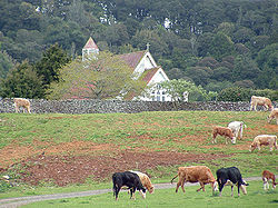
St. Michael's Anglican Church was built on the site of Pene Taui's Pā.[1] During the Battle of Ohaeawai the pā was fortified by Te Ruki Kawiti; the outcome of the battle is considered to be a defeat of the British colonial forces. St. Michael's Anglican Church is 5 miles (8.0 km) from Kaikohe and 2 miles (3.2 km) from the township of Ohaeawai; it stands on a gentle rise a short distance west of the main road. The locality is usually called Ngawha, from the hot springs in the neighbourhood. Cowan (1922) asserts that the site of the church (and earlier pā) is the true Ohaeawai; the European township which has appropriated the name should properly be known as Taiamai.[2]
The 2006 New Zealand Census of Population and Dwellings recorded Ohaeawai's population as 711, a decrease of 15 people since the 2001 census.[3]
Education
Ohaeawai School is a coeducational contributing primary (years 1-6) school with a decile rating of 2 and a roll of 119.[4]
Notes
- ^ "St. Michael's, Ngawha". Don Donovan. http://don-donovan.blogspot.com/2009/07/country-churches-of-nz-9-st-michaels.html.
- ^ Cowan, James (1922). "Volume I: 1845–1864". The New Zealand Wars: a history of the Maori campaigns and the pioneering period. Wellington: R.E. Owen. pp. 73–144. http://www.archive.org/stream/newzealandwarshi01cowa/newzealandwarshi01cowa_djvu.txt.
- ^ Quickstats about Ohaeawai
- ^ "Te Kete Ipurangi - Ohaeawai School". Ministry of Education. http://www.tki.org.nz/e/schools/display_school_info.php?school_id=1058.
External links
Coordinates: 35°21′04″S 173°52′55″E / 35.35111°S 173.88194°E
Categories:- Northland Region geography stubs
- Far North District
Wikimedia Foundation. 2010.


