- Łobez County
Infobox Settlement
name = Łobez County
native_name = Powiat łobeski
settlement_type = County
total_type = Total
image_shield = POL powiat łobeski COA.svg

map_caption = Location within the voivodeship
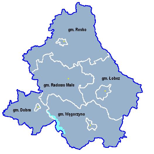
map_caption1 = Division into gminas
subdivision_type = Country
subdivision_name = POL
subdivision_type1 = Voivodeship
subdivision_name1 = West Pomeranian
area_total_km2 = 1065.61
population_total = 38232
population_as_of = 2006
population_density_km2 = auto
population_urban = 20033
population_blank1_title = Rural
population_blank1 = 18199
coor_type = Łobez
latd = 53
latm = 38
lats =
latNS = N
longd = 15
longm = 37
longs =
longEW = E
seat =Łobez
parts_type =Gmina s
parts = Total 5
p1 = Gmina Dobra
p2 =Gmina Łobez
p3 =Gmina Radowo Małe
p4 =Gmina Resko
p5 =Gmina Węgorzyno
blank_name = Car plates
blank_info = ZLO
website = http://www.powiatlobeski.pl __NOTOC__Łobez County ( _pl. powiat łobeski) is a unit of territorial administration and local government (powiat ) inWest Pomeranian Voivodeship , north-westernPoland . Its administrative seat and largest town isŁobez , which lies convert|73|km|mi|0 east of the regional capitalSzczecin . The county contains three other towns:Resko , convert|24|km|mi|0|abbr=on north-west of Łobez,Węgorzyno , convert|12|km|mi|0|abbr=on south of Łobez, and Dobra, convert|22|km|mi|0|abbr=on west of Łobez.A Łobez County existed prior to the abolition of the powiats in 1975. When they were reintroduced in the administrative reforms of 1999, there was initially no Łobez County. The present-day county was created later, in 2002, out of parts of
Gryfice County ,Goleniów County andStargard County (to which Łobez itself had belonged).The county covers an area of convert|1065.61|km2|sqmi|1. As of 2006 its total population is 38,232, out of which the population of Łobez is 10,617, that of Resko is 4,377, that of Węgorzyno is 3,011, that of Dobra is 2,028, and the rural population is 18,199.
Neighbouring counties
Łobez County is bordered by
Gryfice County andKołobrzeg County to the north,Świdwin County to the east,Drawsko County to the south-east,Stargard County to the south-west, andGoleniów County to the west.Administrative division
The county is subdivided into five
gmina s (four urban-rural and one rural). These are listed in the following table, in descending order of population.References
* [http://www.stat.gov.pl/gus/45_655_PLK_HTML.htm Polish official population figures 2006]

Wikimedia Foundation. 2010.