- Trollheimen
Geobox | Range
name = Trollheimen
native_name =
other_name =
other_name1 =
image_size =
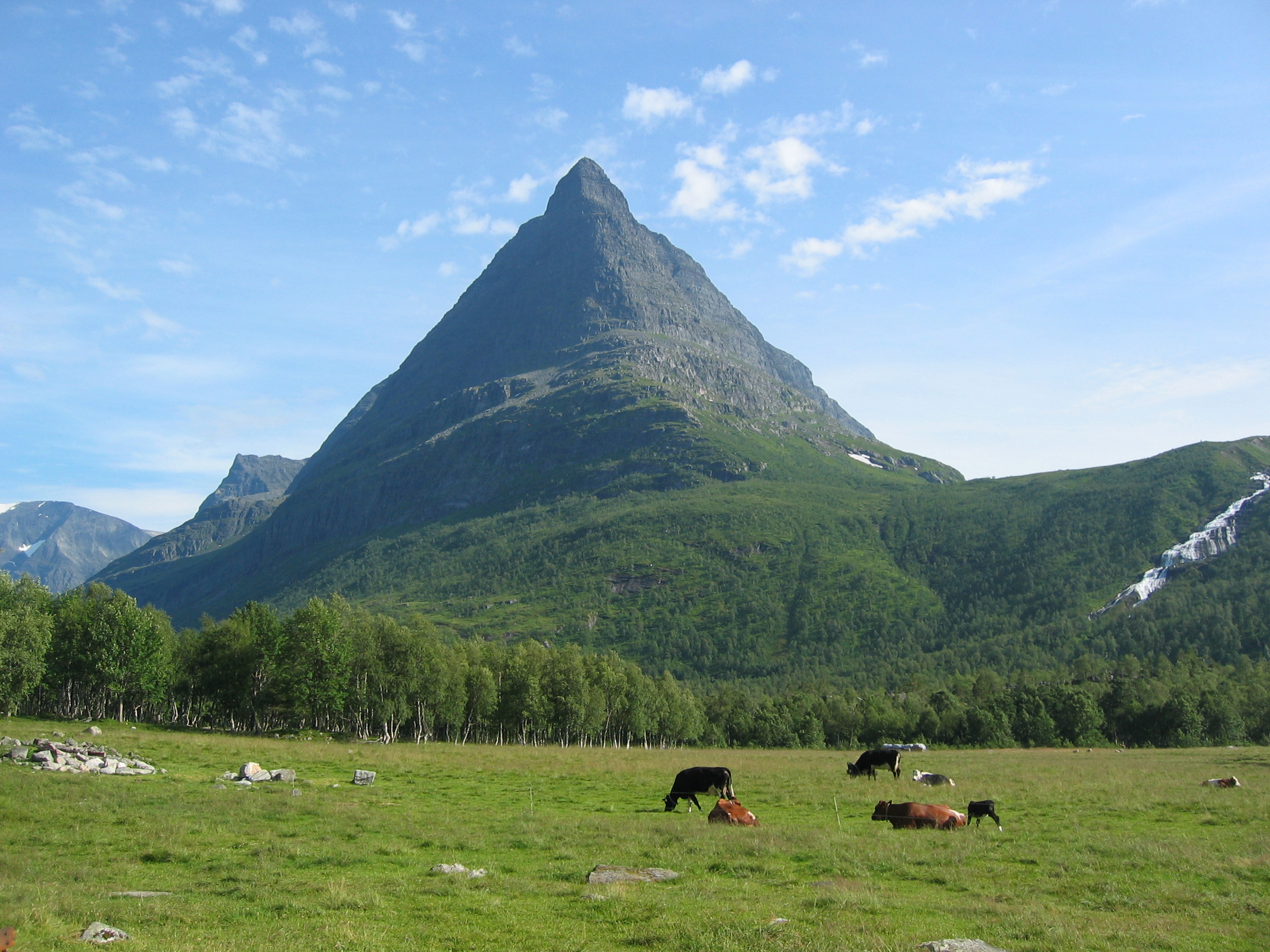
image_caption =Innerdalstårnet
country = Norway
state =
region =Møre og Romsdal
andSør-Trøndelag
region_type = County
district =
district1 =
city =
city1 =
parent =
border =
border1 =
geology =
geology1 =
period =
period1 =
orogeny =
orogeny1 =
area =
length =
length_orientation =
width =
width_orientation =
highest = Store Trolla
highest location =
highest_country =
highest_state =
highest_region =
highest_district =
highest_elevation = 1850
highest_lat_d =
highest_lat_m =
highest_lat_s =
highest_lat_NS =
highest_long_d =
highest_long_m =
highest_long_s =
highest_long_WE =
lowest =
lowest_location =
lowest_country =
lowest_state =
lowest_region =
lowest_district =
lowest_elevation =
lowest_lat_d =
lowest_lat_m =
lowest_lat_s =
lowest_lat_NS =
lowest_long_d =
lowest_long_m =
lowest_long_s =
lowest_long_WE =
woods =
free_name =
free_value =
map_size =
map_caption =
map_first =Trollheimen is a mountain range in
Møre og Romsdal andSør-Trøndelag counties in centralNorway . The mountain range is part of theScandinavian Mountains .The name
The name ('the home of the
trolls ') was proposed byHåkon Løken and used byTrondhjems Turistforening in the 1880s, and is considered a "tourist name" (there was no single name for the entire area before). Trollheimen is now the common name in Norway for this mountain range.Topography and climate
Trollheimen is often considered the most varied of all the mountain ranges in Norway, for several reasons. The mountains in the western part is alpine, with pointed peaks and typical river valleys. The mountains in the east is less pointed with more rounded shapes, and the valleys are wider and bear the hallmark of being created by glaciers. The climate differs from the more
oceanic climate in the west to a considerably drier, continental climate in the eastern valleys, sheltered by the mountains. The valleys in Trollheimen are at an altitude of only about 500 - 800 m and are usually forested, and many are used as pastures ("No: Seterdrift"). There are also several large lakes, likeGjevilvatnet in the east, nearOppdal , andGråsjøen andFoldsjøen in the northern part.The highest peaks are in the southwestern part, Trolla (1,850 m),
Dronningkrona (1,816 m),Kongskrona (1,818 m),Såtbakkollen (1,840 m),Storsomrungnebba (1,799 m). In the northern and eastern part, the highest areSnota (1,668 m),Trollhetta (1,616 m) andBlåhø (1,671 m). In the southeast there isKråkvasstind (1,700 m). The famous mountainInnerdalstårnet (1,452 m) can be climbed without climbing equipment,scrambling .Flora
Trollheimen is known by botanists for the diverse alpine
flora , due to nutritient-rich soil and the varied climate within the mountain range. One of the rarealpine plant s in Trollheimen is Artemisia norvegica. Approximately 1,160 km² of this area is declared a nature reserve. In the midst of the area is theSvartåmoen forest reserve, with undisturbed pine forest, mixed with birch.Innerdalen , in the western part, was Norway's first nature reserve, and is often described as the most beautiful valley in Norway.Recreation
Trollheimen is perfect for
hiking . The most famous route is the "Triangle" ("No:Trekanten") between the three mountain lodges "Gjevilvasshytta", "Jøldalshytta" and "Trollheimshytta", each a fairly long hike of some 7 - 9 hours. It is possible to choose a route covering the three peaks of Trollhetta, a spectacular (but long) hike comparable to the more famousBesseggen route inJotunheimen . The hike to the peak of Snota is often considered one of the most beautiful in Norway. There aretrout in most of the lakes. Except in winter, Gjevilvasshytta can be reached by car, while Jøldalshytta is an easy 4 km hike from the nearest road ("Jølhaugen"). Trollheimshytta is a long hike from any road, in the summer one can park byGråsjøen and hike 11-12 km. There are several other smaller lodges as well, and many more marked routes.Trondheim is roughly one hour drive from the nearest part of the mountain range (Jølhaugen or Resvatn). Gjevilvasshytta is the oldest DNT lodge in Norway, with timber from 1739, and widely regarded as one of the prettiest ( [http://forbruker.no/hyttemagasinet/article1919953.ece# ] ).Archeology
Trollheimen seems to be one of the first areas in Norway to be clear of ice at the close of the last
ice age . There are several traces of stone age people using the mountains as a hunting ground, particularly stone "fences" used to channel scared reindeer herds towards cliffs, where some would fall off and die. These "fences" seems to be very old, as some angles seems to have been blocked by remnants of the ice sheet. Thus, these hunters might have been among the first wave of humans migrating to Norway. In addition, since 1997 there have been many unusually long and warm summers, and theglacier s in Trollheimen and Dovre have retreated, revealing many prehistoricarrowhead s. Some are 4,000 years old or more, but the majority is 1,000 - 2,000 years old. These hunters probably migrated down to the fjords to the west (Sunndalsfjord, Surnadalsfjord, Todal) to avoid the harsh winters. People hiking near glacies in late summer and autumn are encouraged to have a watchfulleye for prehistoricartifact s.External links
* [http://www.turistforeningen.no/turplanlegger/location.php?lo_id=NO_troll&action=Velg DNT:Trollheimen (mostly Norwegian)]
* [http://www.trollshop.net/trolls/trollheimen/ Article with pictures from glaciers in Trollheimen]
* [http://www.walkingworld.com/home/index.asp?id=33&nid=229 Walkingworld:Trollheimen]
* [http://www.oddmund.com/gallery/speilsalen/ Speilsalen - inside a glacier]
Wikimedia Foundation. 2010.