- Kandanos
Infobox Greek Dimos
name = Kandanos
name_local = Κάνδανος
periph =Crete
prefec = Chania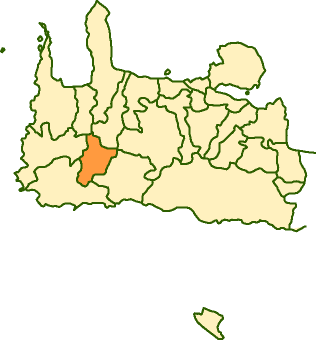
population = 1607
population_as_of = 2001
area =
elevation =
lat_deg = 35
lat_min = 20
lon_deg = 23
lon_min = 44
postal_code = 730 04
area_code = 28230
licence = ΧΝ, XB
mayor = Eftichios Daskalakis
website = [http://www.chania.gr/dimoishow.jsp?lang=en&id=12 Kandanos Website]
caption_skyline =
city_
city_
districts =
party =
since =
elevation_min =
elevation_max =Kandanos or Kantanos ( _el. Κάνδανος or Κάντανος) is a town and municipality in the west of the island of
Crete ,Greece . It is part of theSelino province which covers the southwest of the island inChania Prefecture . The town has 564 residents.History
Kandanos has been settled since the Jurassic period.The town and surrounding area suffered particularly badly from German occupation during
World War II . During theBattle of Crete , resistance fighters had held advancing German soldiers for two days, preventing them from reachingPaleochora to secure it. In retribution the occupiers razed the village to the ground and erected a sign: "Here stood Kandanos, destroyed in retribution for the murder of 25 German soldiers, never to be rebuilt again."The town was rebuilt however, and the sign retained in a
war memorial . Several of the Byzantine churches and their frescoes were restored. Germany donated a waterworks after the war to the village and former soldiers stationed there returned in reconciliation.There is a health center, a police station, a bank branch, a post-office and some stores, taverns and cafes in the village. The municipality also includes 28 villages, like
Anisaraki ,Koufalotos ,Plemeniana ,Kadhros ,Kakodiki andFloria .ee also
*
List of communities of Chania External links
* [http://www.chania.gr/dimoishow.jsp?lang=en&id=12 Municipality description]
* [http://www.gtp.gr/LocPage.asp?id=838&SearchType= GTP description]
Wikimedia Foundation. 2010.