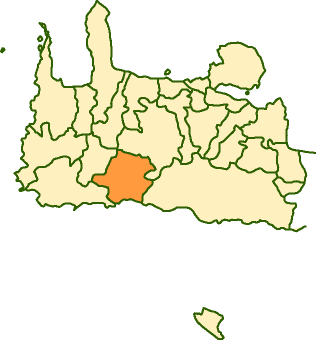
- Anatoliko Selino
Infobox Greek Dimos
name = Anatoliko Selino
name_local = Ανατολικό Σέλινο
periph =Crete
prefec = Chania
population = 1468
population_as_of = 2001
area =
elevation =
lat_deg = 35
lat_min = 16
lon_deg = 23
lon_min = 51
postal_code = 730 09
area_code = 28230
licence = ΧΝ, XB
mayor = Eleftherios Papaderos
website = [http://www.chania.gr/dimoishow.jsp?lang=el&id=2 Anatoliko Selino]
caption_skyline =
city_
city_
districts =
party =
since =
elevation_min =
elevation_max =Anatoliko Sélino ( _el. Δήμος Ανατολικού Σελίνου) is a municipality on the south-west coast of the island of
Crete ,Greece , in the prefecture ofChania . It is part of theSelino province which covers the mountain and coastal region west ofSfakia .The main town of the municipality is Kampanos. The other villages are
Seliniotikos Gyros ,Agia Irini ,Epanochori ,Prines ,Tsiskiana ,Argastiri ,Skafi ,Pera Skafi ,Maralia ,Agriles ,Livada ,Rodovani ,Kamaria ,Maza ,Temenia ,Papadiana , Strati,Moni ,Sougia ,Livadas andKoustogerako .Within Anatoliko Selino lies the
Agia Eirini Gorge , the ruins of the ancient cities ofElyros ,Lissos ,Yrtakina andSyia and many Byzantine churches. The area's main product isolive oil .Sougia is a growing beach resort with a few small hotels andtaverna s.ee also
*
List of communities of Chania External links
* [http://www.chania.gr/dimoishow.jsp?lang=en&id=2 Municipality]
* [http://www.gtp.gr/LocPage.asp?id=813&SearchType= GTP description]
Wikimedia Foundation. 2010.
