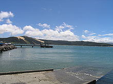
- Opononi
-
Opononi Coordinates: 35°30′45″S 173°23′25″E / 35.5125°S 173.39028°E Country New Zealand Region Northland Region District Far North District Population (2006) - Total 477 Opononi is a settlement on the south shore of the Hokianga harbour in Northland Region, New Zealand.[1] State Highway 12 runs through Opononi. Omapere lies to the south and Whirinaki lies to the north east.
The combined population of Opononi and Omapere was 477 in the 2006 Census, a decrease of 117 from 2001.[2]
Contents
History
Opo was a dolphin who played with children in the summer of 1955-56. There is a sculpture at her grave.[1]
Education
Opononi Area School is a coeducational composite (years 1-15) school with a decile rating of 2 and a roll of 205.[3]
Coordinates: 35°30′45″S 173°23′25″E / 35.5125°S 173.39028°E
Notes
- ^ a b "Hokianga district". Te Ara Encyclopedia of New Zealand. http://www.teara.govt.nz/Places/Northland/NorthlandPlaces/11/en.
- ^ Quickstats about Omapere and Opononi
- ^ "Te Kete Ipurangi - Opononi Area School". Ministry of Education. http://www.tki.org.nz/e/schools/display_school_info.php?school_id=11.
External links
Categories:- Far North District
- Populated places in New Zealand
- Northland Region geography stubs
Wikimedia Foundation. 2010.


