- Keta
Infobox Settlement
official_name = Keta
other_name =
native_name =
nickname =
settlement_type =
motto =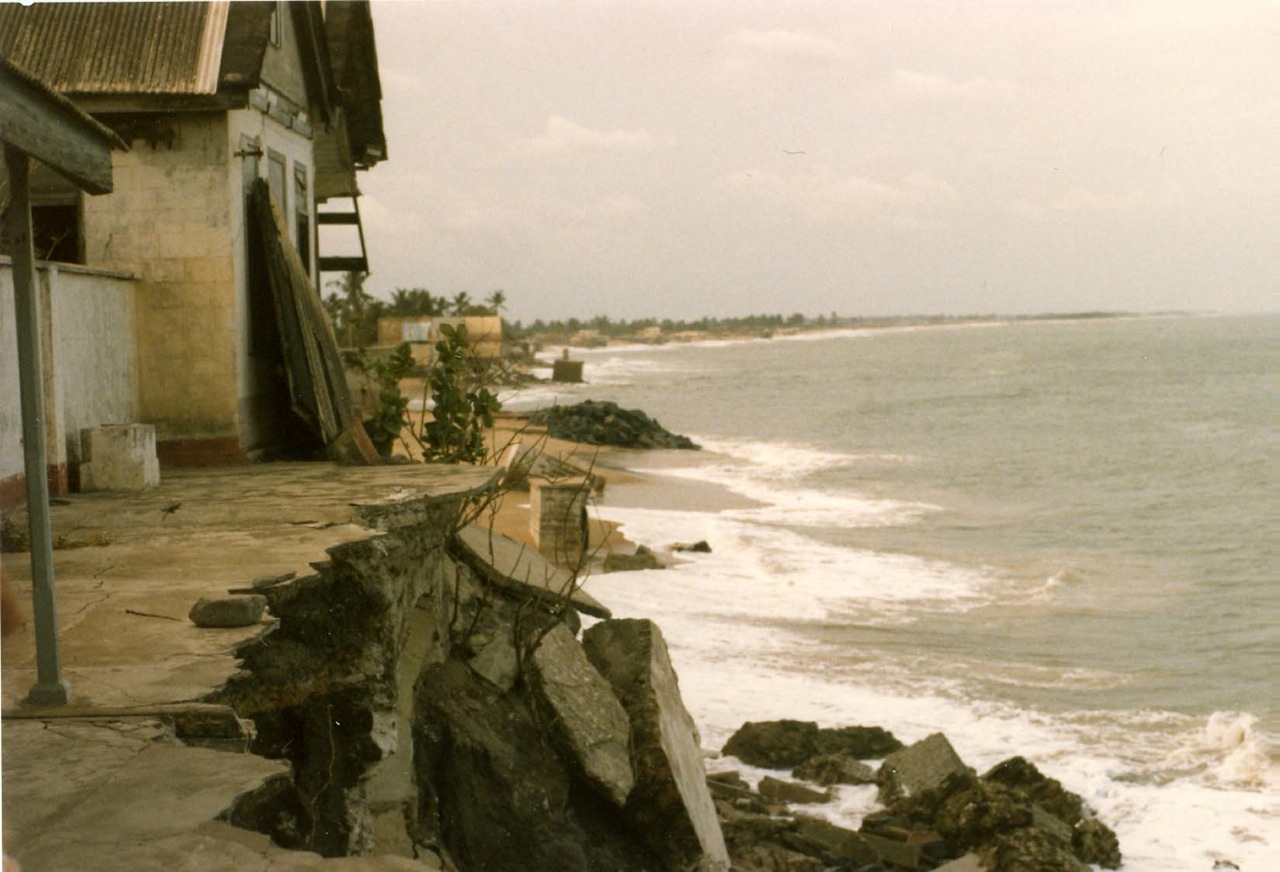
imagesize = 300px
image_caption =Fort Prinsensten on the beach of Keta in 1985
flag_size =
image_
seal_size =
image_shield =
shield_size =
image_blank_emblem =
blank_emblem_type =
blank_emblem_size =
mapsize =
map_caption =
mapsize1 =
map_caption1 =
image_dot_
dot_mapsize =
dot_map_caption =
dot_x = |dot_y =
pushpin_
pushpin_label_position =bottom
pushpin_map_caption =Location in Ghana
subdivision_type = Country
subdivision_name =
subdivision_type1 = Region
subdivision_name1 =Volta Region
subdivision_type2 = District
subdivision_name2 =
subdivision_type3 =
subdivision_name3 =
subdivision_type4 =
subdivision_name4 =
government_footnotes =
government_type =
leader_title =
leader_name =
leader_title1 =
leader_name1 =
leader_title2 =
leader_name2 =
leader_title3 =
leader_name3 =
leader_title4 =
leader_name4 =
established_title =
established_date =
established_title2 =
established_date2 =
established_title3 =
established_date3 =
area_magnitude =
unit_pref =Imperial
area_footnotes =
area_total_km2 =
area_land_km2 =
area_water_km2 =
area_total_sq_mi =
area_land_sq_mi =
area_water_sq_mi =
area_water_percent =
area_urban_km2 =
area_urban_sq_mi =
area_metro_km2 =
area_metro_sq_mi =
area_blank1_title =
area_blank1_km2 =
area_blank1_sq_mi =
population_as_of =2005
population_footnotes =
population_note =
population_total =
population_density_km2 =
population_density_sq_mi =
population_metro =
population_density_metro_km2 =
population_density_metro_sq_mi =
population_urban =
population_density_urban_km2 =
population_density_urban_sq_mi =
population_blank1_title =Ethnicities
population_blank1 =
population_blank2_title =Religions
population_blank2 =
population_density_blank1_km2 =
population_density_blank1_sq_mi =
timezone =
utc_offset =
timezone_DST =
utc_offset_DST =
latd=5|latm=55 |lats= |latNS=N
longd=0|longm=59|longs= |longEW=E
elevation_footnotes =
elevation_m =
elevation_ft =
postal_code_type =
postal_code =
area_code =
blank_name =
blank_info =
blank1_name =
blank1_info =
website =
footnotes =Keta is a city in
Volta Region ,Ghana . It was an important trading post between the 14th and late 20th century via a port and fort built by the Dutch in 1784. Parts of the city was devastated by sea erosion between the 1960s and 1980s. There was a massive sea defence project recently, thus halting the disturbances of the sea. Keta is a potential tourist destination. The sandy beaches and the Keta lagoon between which the city is sandwiched offers a unique setting for the adventurous visitor.Keta Lagoon
The Keta Lagoon is a large body of fresh water separated from the salt waters of the
Gulf of Guinea by a narrow strip of land.This isthmus experiences severe and continuous erosion. A large portion of residential and public infrastructure in the village of Keta, including the road linking it to its northern neighbors, has been lost to the sea. The stretch of land between Keta and Kedzi erodes at a rate of from 4.0 to 8.0 m/year, and is now less than 50 m wide in some places.If the isthmus were to be breached by the sea, harmful changes in salinity and flow within thelagoon would occur, with quite likely catastrophic consequences for local agriculture, fishing industry, commerce, and day-to-day conditions for those who live in Keta, Vodza, Kedzi, and the surrounding area. By the same token, if the massiveVolta River swells in the rainy season, flooding can also post serious threats to the integrity of the fragile fresh-water environment. The Avu-Keta subregion makes its living on the lagoon: its preservation is a crucial first step in the resumption of the area's socio-economic development.The Ministry of Works and Housing of the Republic of Ghana sought to effect this preservation by protecting and stabilizing the shoreline from Keta to Hlorve, implementing a turn-key project to design and construct the needed improvements.The goals of the program are to prevent chronic and periodic coastalerosion andflood ing, reclaim land from the lagoon to expand town and village territories, and link Keta to Hlorve with an 8.3-km-long road.To arrive at an optimal solution Great Lakes conducted a series of studies and tests, which fed into a master plan to generate a cost-effective, environmentally sound solution. The selection process considered results of mathematical and hydraulic tests, structural effectiveness, durability, maintenance, flexibility, and environmental, ecological and social factors. These studies were conducted by Great Lakes and its subcontractors Baird & Associates and Research Planning & Development.The Keta Sea Defense Project has four design/construct components:Construction of an 8.3-km road/causeway between Keta and Hlorve, re-establishing a link lost to erosion.Sea defense works to limit further erosion by stabilizing the shoreline with one offshore breakwater and seven headland groynes, a feeder beach and beach nourishment placed between the groyne bays from Keta to Hlorve.Construction of a flood control structure to provide inhabitants around the lagoon with relief from extreme flooding conditions. Land reclamation from the lagoon in the area of Keta, Vodza and Kedzi, providing areas where housing and businesses can be rebuilt. The project promotes protection of the environment through sustainable use, and fosters socio-economic interaction and growth.For example, there will be added territory for agriculture, and the road/causeway provides and re-opens the way for traffic to neighboring Togo and coastal Ghanaian cities, towns and villages, providing farmers and other businesses in the area access to markets.The new beaches and rubble mound headlands will create protected areas where fishers can launch their canoes, and give a secure home to the shore-based drag-net fishing industry.The flood relief will decrease farmer losses due to flooding of the lagoon, and reclaimed land will provide new areas for the creation of homes, businesses and communities.
Finally, the Keta Sea Defense Project brings a constructive commercial American presence in the West African economy, generating purchase of U.S. goods and services totally more than US$75,000,000. Great Lakes assisted in arranging financing for the project with the U.S. Eximbank.
Dredging & Quarry Work Start Keta Sea Defense
The 18 inch (457 mm) cutter suction (CS)
dredge "Alabama", built byEllicott International , commenced operations on the Keta Sea Defense Project on 30 May 2000, stripping soft unsuitable material overlying future borrow sand and discharging to create adjacent island bird habitats. Great Lakes retrofitted the "Alabama" with new anchor booms from Ellicott to improve its operating efficiency.Once sufficient area of the borrow site has been stripped, the "Alabama" will begin pumping fill for the main roadway link. Mobilization of heavy civil equipment and quarry kit continues, with the last shipment departing the U.S. on June 21.The residential camp at Weta has been completed and is occupied, along with the site offices at the marine landing and office and repair facilities at the quarry.The following activities are underway:Mobilization of 24 inch (610 mm) CS dredge "Utah" on the Chinese submersible Sha He Kou;Transport of quarry equipment from Houston and Newark;Road transport of the 777 trucks and 998 loaders from
Tema to the quarry;Reinforcement of pipe and culvert crossings on the haul road;Grading and maintenance of haul road between the guarry and the jobsite;Soils investigation along road and in the adjacent borrow pit area;Removal of overburden at the quarry to prepare for mining rock; Erection of storage and additional maintenance facilities at the quarry for civil equipment. Drilling and blasting operations in the quarry will begin in July and rock processing in August. Rock hauling for construction of Groyne No. 4 will begin in November.

Wikimedia Foundation. 2010.