- Mangole Island
-
Mangole 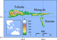
Geography Location South East Asia Coordinates 1°48′S 125°48′E / 1.8°S 125.8°E Archipelago Maluku Islands Country Indonesia
Mangole (Xulla Mangola - earlier name[1].) is a large island in the Sula Islands, which again are part of Maluku Islands in Indonesia. It is located at 1°48′S 125°48′E / 1.8°S 125.8°E, east of Taliabu Island and north of Sanana Island. About 38,000 people live on the island of Mangole. Its economy is dominated by the timber industry.[1]Notes
- ^ Goodall, George (Editor)(1943) Philips' International Atlas London, George Philip and Son map 'East Indies' pp.91-92
- ^ Asia-Pacific Quake rocks Indonesian islands from BBC News, 30 November 1998
Categories:- North Maluku
- Maluku Islands
- Maluku Islands and New Guinea (Indonesia) geography stubs

Wikimedia Foundation. 2010.