- Corsehill, Lainshaw, Robertland and Dunlop
Corsehill, Lainshaw, Robertland and Dunlop are all in the old feudal Baillerie of
Cunninghame , nowEast Ayrshire ,Scotland . This local history article starts with the original land holdings of the baronies within the baillery ofCunninghame and follows these through to the country estates of more recent times and finally through to the local authority areas of the present day. This geographic area is famous for its milk and especially its cheese production from the Ayrshire, Cunninghame or Dunlop breed of cattle.The Lands of Corsehill
Godfrey de Ross was an early holder of the castle and lands of Corsehill, moving his seat here from the castle at Boarland (also 'Borland') or Dunlop hill. The De Ross family are now represented by the Earls of Glasgow. Andrew Cuninghame, second son of Alexander Cunningham, 4th Earl of Glencairn, was the first of the House of Corsehill in 1532. He was a great supporter of the reform movement and had his lands forfeited, later returned and died in 1545. Cuthbert Cuninghame inherited and married Maud Cuninghame of Aiket Castle. He had two sons, Alexander and Patrick, the latter being involved in the murder of Hugh,
Earl of Eglinton . Patrick was murdered in revenge by the Montgomeries.Dobie, James D. (ed Dobie, J.S.) (1876). "Cunninghame, Topographized by Timothy Pont" 1604–1608, with continuations and illustrative notices. Pub. John Tweed, Glasgow.]Alexander Cuninghame inherited and married Marion Porterfield of Duchal. Alexander Cuninghame of Corsehill was given the dignity of a Baronet in 1672. Sir David Cuninghame is the last of the family to be recorded as dwelling at Corsehill Castle (Pont 1876). In 1820 the lands included Bonshaw, High and Low Chapelton, Lainshaw, Kirkwood, Sandielands, Bankend, Gallowayford, and Corsehill. In 1832 Sir Thomas Montgomerie-Cuninghame of Corsehill and Kirton-holme (near
Lanark ) was the eighth baronet.Dobie, James D. (ed Dobie, J.S.) (1876). "Cunninghame, Topographized by Timothy Pont" 1604 – 1608, with continuations and illustrative notices. Pub. John Tweed, Glasgow.] The Montgomery-Cuninghame of Corsehill Baronets are still extant, withJohn Montgomery-Cuninghame of Corsehill and Kirton-holme, 12th. Baronet now representing the family.Corsehill and Ravenscraig Castles
Some considerable confusion exists about the sites and naming of these castles in Stewarton. The name 'Ravenscraig' has probably arisen from 'Reuincraig' which is itself derived from 'Ruin Crag', i.e. rock / stone ruins, so it isn't so much a name, as a description. We know from historical records about Godfrey de Ross and his family of Corsehill Castle, they were Lords of Liddesdale in the Borders and later on the
Cunninghame s became the holders. Corsehill (also Crosshill) castle is said to have been on the east side of the Corsehill Burn and only a few remains were said to exist to show its site, however the 1860 OS indicates no ruins of any description.StevenSteven, Rev. Charles Bannatyne (Revised 1842). Parish of Stewarton. Presbytery of Irvine, Synod of Glasgow and Ayr] states that William Dean held the feu for the area of Templehouse, now more commonly called 'Darlington'. The 1860 OS map does record the site of Templehouse which had a small fortalice associated with it. Its site was at Darlington, the village which lay just beyond
Stewarton on the Kingsford road before the East Burn. This area continued to be called Templehouses for many years after the stones were removed by local people for building purposes. Corsehill Castle is shown in one old print of 1691 by Gross as Corsehill House and substantial remains existed until the railway was constructed and most of the ruins were Craignaught hill lies in the north-east area of the Parish of Dunlop, the Clerkland Burn running beneath and on to Dunlop House. On the lower slopes of Craignaught Hill was fought a singularly unusual battle between the Boyds of Kilmarnock and the Stewarts ofDarnley . Sir Alan Stewart had been treacherously slain by Sir Thomas Boyd; his son Alexander Stewart, was determined to take revenge.Sir Thomas Boyd was surprised on the night of 9th. July, 1439, whilst riding past Craignaught on his way north and although outnumbered, he and his followers fought on, even taking agreed rest periods indicated by the sounding of a horn. The remaining Boyds placed themselves "back to back, they closed up their ranks, and, forming a circle, they grimly set themselves to beat back the Stewarts or else die where they fought." Eventually and inevitably Sir Thomas Boyd was killed, whilst fighting Sir Alexander Stewart himself, stabbed in the back by a Stewart soldier, and a large number of his followers were also killed. The name is given as Sir Robert Boyd in at least one version of the tale.Robertson, William (1889) "Sir Robert Boyd of Dean castle and his last combat with Stewart of Darnley." in "Historical Tales and Legends of Ayrshire." Pub. Hamilton, Adams & Co. P. 295 - 305.Robertson, William (1889). "Historical Tales and Legends of Ayrshire." Pub. T. D. Morison. Glasgow. P. 302 - 304.
The results of this encounter led to killings and counter killings which involved a great part of the West of Scotland. Boyd's wife had previously dreamed all of that which came to pass and died of grief within days of her husband death.Robertson, William (1908). "Ayrshire. Its History and Historic Families"." Vols. 2. Pub. Grimsay Press (reprint). ISBN 1-84530-026-2. P. 332.] The 1860 OS marks 'Boyd's Hill' and 'Boyd's slack' (Scots for a narrow pass) [http://en.wikibooks.org/wiki/Local_History_Dictionary#B_Words/ Local History Dictionary] ] to the north of Craignaught on the old lane to Grange Farm, now named South Grange.
Boyd's Hill has been undamaged (2007) by the quarrying and domestic waste disposal operations at Craignaught and the Boyd's slack is also clearly identifiable.
Boyd's Hill at Craignaught Gallery 2007
The Gemmells of Templehouse
The Knights Templar are remembered in the name of this property, which since 1570 was in the hands of the Gemmill or Gemmell family. In 1596 Patrick Gemmill resigned the Templelands of Dunlop Hill into the hands of the Superior, Lord Torphichen, in favour of his eldest son. The Sandilands, Lords Torphichen are remembered elsewhere, such as Sandilands Farm near Kennox, although the farm name has now been changed to Bank End. The Gemmells still held Templehouse in the 1860s.
The Lands of Hapland
Prior to 1549 Hapland was part of the estate of Dunlop. David Dunlop exchanged or 'excambied' Hapland for the lands of Borland and in 1612 Patrick Cunninghame sold these lands to Gabriel Porterfield, son of Alexander Porterfield of that Ilk. Gabriel Porterfield of Porterfield in 1618 married Mariot Crawfurd and inherited the lands of Gills, Lothrihill, the Templeland and Maynes (Mains) of Hapland, including the mansion house. Gabriel Porterfield also took possession of Dunlop Hill, Wattirland (Waterland) and Halketh, with the loch (now drained). Dobie relates that "On 31st May, 1638, Gabriel Porterfield purchased from Neil Ryburn of that Ilk the 13s 4d. land of old extent of Ryburn, commonly called Temple-Ryburn. The estate of Hapland consisted of Brokwelmure (Brockwellmuir), Dunlophill-Montgomerie and Ryburn; later part of Lainshaw was purchased as well."Dobie, James D. (ed Dobie, J.S.) (1876). "Cunninghame, Topographized by Timothy Pont" 1604–1608, with continuations and illustrative notices. Pub. John Tweed, Glasgow.]
The Laird of Hapland was the ruling elder in the Parish of Dunlop in 1649 and was a captain in the Scots army when Cromwell was in Scotland, for which his lands were sequestrated. The last of the male line died when he fell off his horse when returning from Stewarton about 1765 or 1770. Lillias Porterfield married William Somerville of Kennox. Their youngest child, a daughter, married Colonel McAlester, Laird of Loup, in
Kintyre . A descendent built Chapelton House near Stewarton. Hapland is near Dunlop. In 1820 the estate was of convert|200|acre|km2 and the proprietor was Lieutenant-General Alexander Trotter. The old mansion house was demolished around 1876 as it was not in keeping with the modern age.Dobie, James D. (ed Dobie, J.S.) (1876). "Cunninghame, Topographized by Timothy Pont" 1604–1608, with continuations and illustrative notices. Pub. John Tweed, Glasgow.] A new steading was built at the site, possibly the 'Newhouse' marked on the OS maps. Some of the old tree wind-breaks and policies of the estate can still be made out. It seems likely that Temple-Ryburn had it's name changed to Hapland at around this time as the OS of 1858 shows Ryburn in the same position as later maps (1897, etc.) show Hapland.The Thurgatstane or Ogrestane
The
Thurgartstone is just outside of Dunlop on the Lugton Road in the valley of the Black Burn. It is in a sheltered spot, with ample running water and well hidden from immediate view. In the middle of a field near the Chapel Crags is the Thurgatstane or Ogrestane, also known as the Thorgatstane, Field Spirit Stane, T'Ogra Stane, Thugart Stane, Ogirtstane, Ogart stane, Horgar Stane, Fiend's Stane or Thougritstane. It is a glacial erratic stone, composed of blue augitic porphyrite and is quite unlike the 'native' stone of the district, weighing about 25 tons and measuring about twelve feet by eight feet as measured above groundBayne, John F. (1935). "Dunlop Parish - A History of Church, Parish, and Nobility". Pub. T.& A. Constable, Pps. 10 - 16.] "The Church of Dunlop." Archaeological & Historical Collections relating to Ayr & Wigton. 1884. Vol. IV. Pub. Ayr & Wigton Arch Assoc. P. 35.] . It is set near the site of the pre-reformation St.Mary's Chapel and has long been associated with pagan ritual practices.Few places have so many different names attached to them. One explanation is that the stone is 'Thor's Great Stone', another is that is "Thou Great Stone" or just '"grit stane"Paterson, James (1863-66). "History of the Counties of Ayr and Wigton". V. - III - Cunninghame. J. Stillie. Edinburgh.] , whilst 'The Stone of the Ogre' may reflect some forgotten legend of how the stone came to be in this position. Some names may be spelling errors perpetuated by or from Ordnance Survey and other maps. Another explanation of the name is that it is derived from 'Tagairtstane,' meaning the priest's stone. This 'Druidical' stone may have been a 'rocking or logan' stone at one time, but it is now firmly set in the 'rubbish' and soil.
It is recorded that even as late as "the time of Popery" the devotees of that religion, in doing penance, used to crawl on their knees round this stone and cry, "O thou grit stane" from a belief that the Deity was in a peculiar manner present at that hallowed relicMacIntosh, John (1894). "Ayrshire Nights Entertainments: A Descriptive Guide to the History, Traditions, Antiquities, etc. of the County of Ayr." Pub. Kilmarnock. P. 195.] . Farmers from Brandleside Farm were bound to protect, by not removing it or ploughing within a set distance of the stone, possibly because of a tradition of pagan burials around this monument.Paterson, James (1863-66). "History of the Counties of Ayr and Wigton". V. - III - Cunninghame. J. Stillie. Edinburgh.] Some recollections of
May Day events being held at the site are current and the site is listed and protected byHistoric Scotland . A fine view of Dunlop or Borland Hill, the site of Dunlop Castle once held by the De Ross family, can be seen from the stone.The Monastic Settlement
The history of the monastic settlement and the chapel of
Saint Mary Paterson, James (1863-66). "History of the Counties of Ayr and Wigton". V. - III - Cunninghame. J. Stillie. Edinburgh.] at theThurgartstone is a parallel example to the Chapel Hill site atChapeltoun , where a Christian centre was established to surplant the pagan significance of the site. Monastic cells, a chapel and a graveyard are all lost to view, constructed by the monks ofKilwinning , only the name 'Saint Mary's' given to the nearby 'modern' dwellings, built on the site of the chapel record past significance. Chapelhouse Farm is located beside the road nearby. The Holy Well still exists, the nearby houses pumping water up from its source. The water from the well used to run under the road and emerge in a trough surrounded by a metal fence. Only a concrete manhole indicates this trough now (2006). In 1856 the water for baptism in Dunlop Kirk was still drawn from this Holy Well."Name Book" (1856). Ordnance Survey.]The chapel can never have been very large and was abandoned at the time of the Reformation in Scotland led by the ex-Roman Catholic priest
John Knox (1514 to 1572). The stones were robbed / mined by locals and the last remaining stones were taken away by a farmer in the 1830’s. It stood on a rock from which a beautiful stream of water gushed into a small rivulet, this originally being crossed by steps, called the "Lady's steps" before the Chapelhouse Bridge was built.Paterson, James (1863-66). History of the Counties of Ayr and Wigton. V. - III - Cunninghame. J. Stillie. Edinburgh.] A carved relic of the old chapel, supposed to have been the font for holy water, was for some years used a trough for the pigs until it was finally broken up and used as building material."The Church of Dunlop." Archaeological & Historical Collections relating to Ayr & Wigton. 1884. Vol. IV. Pub. Ayr & Wigton Arch Assoc. P. 35.] The 1858 OS map locates the Lady's Steps near Hapland Mill on the Stewarton side of the town, crossing the Glazert. Patterson and BayneBayne, John F. (1935). "Dunlop Parish - A History of Church, Parish, and Nobility". Pub. T.& A. Constable, Pps. 10 - 16.] , both local people writing in 1866 and 1935 respectively, place the steps at Chapel Crags. The first Statistical Account of Ayrshire also places the steps at Chapel Crags.Sinclair, Sir John (1791 - 1799). "The Statistical Account of Scotland. Ayrshire."] It seems odd to name these steps after a chapel that is a significant distance away in another valley, so a cartographers error may explain the situation as recorded in the first OS Name Book. A field near the 'Druid Stone' is called Templecroft and the first Celtic ‘Culdee ’ church may have been situated here, later replaced by the Roman Catholic Chapel. Ironically the pagan or Druidical stone is still there, but no sign of the Christian sites are visible, apart from the inconspicuous holy well in the field bordered by the burn.Dunlop Church and the Picture House
The church was probably built in around 1766, however by 1834 it was dilapidated and demolition followed, resulting in the construction of the Dunlop parish church that we see today. Parts of the original building are in use as tomb stones. Barbara Gilmour, famous for introducing the production of Dunlop Cheese, is buried in the churchyard. Major McAlester of Kennox, then a heritor, obtained the 1792 bell and Miss McAlester and Mr.Charles G. S. McAlester returned it to the Kirk Session in 1935 to honour the centenary of the present church.Bayne, John F. (1935). "Dunlop Parish - A History of Church, Parish, and Nobility". Pub. T. & A. Constable, P. 10 - 16.] Hans Hamilton was the first Protestant vicar of the church. His son James was created
Viscount Clandeboye andBaron Hamilton for his many services toJames VI in establishing and maintaining Protestantism inIreland . His five brothers also established estates in Ireland. A handsome mausoleum was constructed in 1641 over their graves by James and this was so ornately painted and gilded in the Roman Catholic manner that it attracted the sobriquet of 'The Picture House'. The flat tombstone of Hans Hamilton was originally on the floor, but this was later removed and placed on the south wall.Bryden, Robert (1915). "Ayrshire Monuments". Limited edition of 50. Pub. Stephen and Pllock. Ayr. Section 10.] It was much neglected and vandalised even in 1699, but in 1734 it was given some much needed repairs. Around 1849 Colonel Mure of Caldwell had further repairs carried out."The Church of Dunlop." Archaeological & Historical Collections relating to Ayr & Wigton. 1884. Vol. IV. Pub. Ayr & Wigton Arch Assoc. P. 45.] Bryden, Robert (1915). "Ayrshire Monuments". Limited edition of 50. Pub. Stephen and Pllock. Ayr. Section 10.] The marble statues of Hans and his wife have now been removed to a place of safety for their protection (2005).Viscount Clandeboye also built and invested a school, now known as Clandeboye Hall and used by the church for events. Carved above the door was the date 1641 with the statement "This school is erected and endowed by Iames Clandeboyes, in love to this parish in which his father Hans Hamilton was pastor 45 years in King Iames the sixt his raigne." The carving was removed when the school was sold as a private dwelling."The Church of Dunlop." Archaeological & Historical Collections relating to Ayr & Wigton. 1884. Vol. IV. Pub. Ayr & Wigton Arch Assoc. P. 40.]
The Rev William Gebbie was the last minister to come into the parish under the old system of patronage, in this case that of the
Earl of Eglinton . William was a fervent evangelist and the 'Dunlop Revival' shook the whole parish until the reverend was charged with heresy in the early 1860s! He remained as minister until 1883.Dunlop Ancient & Modern. An Exhibition. March 1998. Editor. Dugald Campbell. p. 6. ]The Carlin Stone or Hag Stone at the Commoncraigs
On top of the Commoncraigs or Common Crags overlooking Dunlop and the Glazert is a large procumbent boulder known on the OS map as the ‘Carlin’s Stone or Stane’. A Carl is a commoner, a husband or in a derogatory sense, a
churl or male of low birth. More commonly the name Carlin was used as a derogatory term for a woman meaning an 'old hag'. It is also said to be a corruption or Scots equivalentMcHardy, Stuart (1999), "Scotland: Myth, Legend & Folklore". Pub. Luath Press, Edinburgh. ISBN. 0-946487-69-3 P. 25.] of the Gaelic word “Cailleach”, meaning a witch or the 'old Hag', the Goddess of Winter. This would therefore be the Witch’s or Hag's Stone, one of several in Scotland with this name.Near 'Kirkhill' outside Stewarton are several Kilbrides.
Bride ,Brigit or St Brigid was originally a Celtic Goddess linked with the festival ofImbolc , the eve of the first of February. She was the goddess of Spring and was associated with healing and sacred wells, therefore the antithesis of the Carlin. Carlin's Tooth is the name of a rock outcrop in the borders between Knocks Knowe and Carter FellMack, James Logan (1926). "The Border Line." Pub. Oliver & Boyd. P. 215.] . Three farms named 'Carlingcrags' are to be found above Darvel in East Ayshire.A Carlin Stone is situated on Whitelee Moor near Craigends farm, below Cameron's Moss. The nearby Carlin burn eventually runs into the Hareshawmuir water.
Gallery
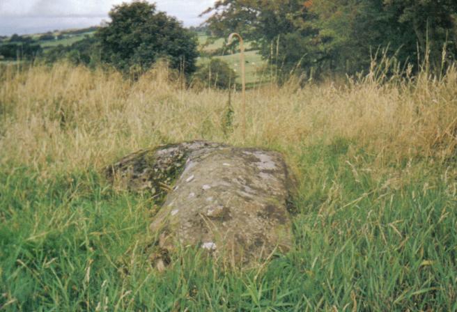
A view of the Carlin Stone. 
The Carlin stone from the Commoncraigs Community Woodland. 
Illustrating the procumbent position of the stone. Lugton Village
When the
stage coach passed throughLugton on its way toGlasgow in 1830s, the hamlet consisted of only four houses: the hotel or inn, the smithy, and two toll houses. The Lugton Inn was sadly destroyed by fire in the early 2000s. In around 1850 iron ore was found nearby and Messrs. Merry & Cunninghame, Ironmasters, built a row of houses for 200 people. A brickworks was later established to use up the blaes bing produced in the mining of the iron ore, but it closed in 1921Milligan, Susan. Old Stewarton, Dunlop and Lugton. Pub. Ochiltree. ISBN 1-84033-143-7.] . A lime works had existed near Lugton as far back as 1829: it is shown on Aitken's map of Cunninghame.The Darien Affair
The
Darien Company was an attempt by the Scots to set up a trading colony in America in the late 1690s, however the opposition from England and elsewhere was so great that the attempt failed with huge losses and great financial implications for the country and for individuals. Half of the whole circulating capital of Scotland was subscribed and mostly lost. In Cunninghame some examples of losses are Major James Cunninghame of Aiket (£200), Sir William Cunninghame of Cunninghamhead (£1000), Sir Archibald Mure of Thorntoun (£1000), William Watson of Tour (£150) and James Thomson of Hill in Kilmaurs (£100).Dobie, James D. (ed Dobie, J.S.) (1876). "Cunninghame, Topographized by Timothy Pont" 1604 – 1608, with continuations and illustrative notices. Pub. John Tweed, Glasgow.]The Highland host
To prevent the Covenanters holding 'Conventicles', King Charles II moved highland troops, the 'Highland Host' into the west-land of Ayrshire.Robertson, William (1905). "Old Ayrshire Days". Pub. Stephen & Pollock. Ayr. P. 299 - 300.] "They took free quarters; they robbed people on the high road; they knocked down and wounded those who complained; they stole, and wantonly destroyed, cattle; they subjected people to the torture of fire to discover to them where their money was hidden; they threatened to burn down houses if their demands were not at once complied with; besides free quarters they demanded money every day; they compelled even poor families to buy brandy and tobacco for them; they cut and wounded people from sheer devilment." The cost of all this amounted to £6062 12s 8d in Stewarton parish alone.Robertson, William (1905). "Old Ayrshire Days". Pub. Stephen & Pollock. Ayr. P. 203.]
Micro history, local traditions and etymology
Sir A. Cunningham of Corsehill attended the famous 1839
Eglinton Tournament in what is nowEglinton Country Park and he was alloted a seat in the Grand Stand.Aikman, J & Gordon, W. (1839) An Account of the Tournament at Eglinton. Pub. Hugh Paton, Carver & Gilder. Edinburgh. M.DCCC.XXXIX. P. 8.] The nameStewarton is said to derive from Walter, High Steward of Scotland to David I who lived here in the 12th. century. Robert the Steward, a direct descendent, became King Robert II.Kerr, T. Macfie (1936). "The Bonnet Toun".] The town had 1800 inhabitants in 1820. Walter was the son of Alain who had been invited by Henry 1st. to live in England. He returned to Scotland withKing David I in 1141.RobertsonRobertson, George (1820). "Topographical Description of Ayrshire; more Particularly of Cunninghame: together with a Genealogical account of the Principal families in that Bailiwick". Cunninghame Press. Irvine.] in 1820 refers to Macbeth-hill as being part of the Corsehill lands. Troilus Montgomery became Laird of MacBeth-hill or Magbie hill in Peeblesshire.Timothy Pont in 1604 - 08 records that so thickly was the district about
Stewarton and along the banks of the Irvine populated for a space of three or four miles (6 km) "that well travelled men in divers parts of Europe (affirm) that they have seen walled cities not so well or near planted with houses so near each other as they are here, wherethrough it is so populous that, at the ringing of a bell in the night for a few hours, there have seen convene 3000 able men, well-horsed and armed."Robertson, William (1908). Ayrshire. Its History and Historic Families. Vol.1. Pub. Dunlop & Dreenan. Kilmarnock. P. 303]Above Kirkwood near Dunlop is a property called 'Ravenslie', not far from 'Ravenscraig' castle.Robertson, George (1820). "Topographical Description of Ayrshire; more Particularly of Cunninghame: together with a Genealogical account of the Principal families in that Bailiwick". Cunninghame Press. Irvine.] In 1820 David Cunninghame was the proprietor at a rental of £39 13s. 4d. Ravens are still found in the district.
The 'Leddy o'Clumbeith' is a ghost story told by Dr. DuguidService, John (Editor) (1887). The Life & Recollections of Doctor Duguid of Kilwinning. Pub. Young J. Pentland.] circa 1840 in the 1820s. A servant girl from the farm of Clonbeith was making her way to the Blair Tavern to keep a
tryst when she fell into a mine shaft, horse and all, and was killed. Others say that her 'lad' killed her and then jumped into the shaft after her. Her ghost haunts the fields aroundAuchentiber .A new gravitational water supply was opened for Dunlop in 1896, fed from a spring at Sidehead, the old water supply having been condemned.Dunlop Ancient & Modern. An Exhibition. March 1998. Editor. Dugald Campbell. p. 6. ]
In the 1600s Stuartoune had fairs on the first Thursday of January, the first Monday of May, and the last Wednesday of October. A weekly market on Thursdays is recorded as being not well attended.Dobie, James D. (ed Dobie, J.S.) (1876). "Cunninghame, Topographized by Timothy Pont" 1604 – 1608, with continuations and illustrative notices. Pub. John Tweed, Glasgow.]
In 1820 only six people were qualified to vote as freeholders in Stewarton Parish, being proprietors of Robertland (Hunter Blair), Kirkhill (Col.J.S.Barns), Kennox (McAlester), Lainshaw (Cunninghame), Lochridge (Stewart) and Corsehill (Montgomery Cunninghame). Dunlop had only two people qualified to vote by right as freeholders.Dobie, James D. (ed Dobie, J.S.) (1876). "Cunninghame, Topographized by Timothy Pont" 1604 – 1608, with continuations and illustrative notices. Pub. John Tweed, Glasgow.] The Draffen Stone used to be located in a field near the house of the same name. Due to a housing development it has been moved to a site in front of Draffen House. It is not known whether this stone is merely a 'rubbing stone' for cattle or a
menhir . It is not recorded byHistoric Scotland .Braehead House in Stewarton is a rare example of a 'Bank' from the times when private houses were used, rather than purpose-built premises. The windows of the strongroom still have their iron bars in place.Watt, Robert (2006). Oral communication.]
The 'Stewarton Sickness' refers to the powerful religious revival that started in 1625 and continued to involve Stewartonians in strong religious attitudes until comparatively recent times.Kerr, T. Macfie (1936). "The Bonnet Toun".]
Lainshaw Mill, below the railway viaduct, was famous for the large
Rowan Tree growing out of its chimney. The mill ceased grinding corn in the 1930s and was completely demolished in the second half of the 20th. Century after a disastrous fire, the fate of many an old mill. In the 1860 William Eaglesham was the miller, with his wife Helen Wilson. He died aged 70 and is buried in the Laigh Kirk graveyard. The Lainshaw viaduct was opened on August 3rd. 1868, but did not actually have track and trains running over it until March 1871. Colonel Mure of Caldwell, Caldwell performed the opening ceremony.House, Jack (1970), "Stewarton". Pub. Stewarton Bonnet Guild.] The Lairds of Corsehill were the Deacons Heritable of the Bonnet Court of Corsehill which regulated the activities of the Stewarton bonnet makers.David Dale was a native of Stewarton, born in 1739, son to a grocer in the town. He started life as a cowherd and went on to fame and fortune. He was brought up in a two story thatched house at the 'cross' in Stewarton.Shaw, John (1953). "Ayrshire 1745 - 1950. A Social and Industrial History of the County". Pub. Oliver & Boyd. P. 37.] Given the strong weaving community in the town it is ironic that he set up his factory atNew Lanark , amongst other places. He was very generous to good causes, giving away up to £50,000.Kerr, T. Macfie (1936). "The Bonnet Toun".]The first Corsehill Queen is said to be
King Malcolm III second wife, Queen Margaret, niece ofEdward the Confessor of England. This Malcolm III, also known as Canmore, was also Lord of Corsehill.Kerr, T. Macfie (1936). "The Bonnet Toun".] She was canonised and St.Margaret's Chapel is the oldest surviving building atEdinburgh Castle , Highlanders however called her the 'Accursed Margaret.'Best, Nicholas (1999). The Kings and Queens of Scotland. Pub. London. ISBN 0-297-82489-9.]One of the Lady Robertlands of Robertland Castle was a practical Christian, mingling with the poor of the district, distributing alms and tending the sick.Dobie, James D. (ed Dobie, J.S.) (1876). "Cunninghame, Topographized by Timothy Pont" 1604–1608, with continuations and illustrative notices. Pub. John Tweed, Glasgow.] Lady Elizabeth Montgomerie's ghost is said to haunt Lainshaw Castle, wandering the corridors wearing a green dress and carrying a candle. She was implicated in the plot that resulted in the murder of the Earl of Eglinton.
Dunlop Cattle are supposed to have originated here or within the parish, bred by Dunlop of that Ilk from improved stock from Holland in around 1550 to 1700 or later. The breed, also known as Cunninghame or
Ayrshire cattle are pied, white and brown, short in leg, long in the horn, straight in the back: the bulls are fiery in temper and the cows are peculiarly placid and docile. They produce milk which is very high in butterfat.Bayne, John F. (1935). "Dunlop Parish - A History of Church, Parish, and Nobility". Pub. T.& A. Constable, Pps. 10 - 16.]The Gaelic, An t-sagairt, the priest (See Thurgatstane), gave rise to the Scottish Name Taggart..Kerr, T. Macfie (1936). "The Bonnet Toun".]
The 1779 Lainshaw estate map shows the
Glebe meadows running down from the Laigh Church to the river and as far as the Old Stewarton Road at Kirkford.Lainshaw Estate map of 1779. Scottish National Archives.] In 1797 Magbie Hill above Stewarton has a field called 'Stone Field' which may record a standing stone now long destroyed or possibly moved as the nearby farm has two large boulders in front of it. Coal pits are marked in the vicinity of Magbie Hill, possibly explaining the name, as 'mag' was a term used for poor quality coal. The nearby 'Water Plantation' was known as 'Magbie-hill Plantation'.Lainshaw Estate map of 1779. Scottish National Archives.]
Wikimedia Foundation. 2010.