- Matt, Switzerland
-
Matt 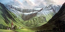
Country Switzerland 
Canton Glarus District n.a. 46°58′N 9°10′E / 46.967°N 9.167°ECoordinates: 46°58′N 9°10′E / 46.967°N 9.167°E Population 367 (December 2009) - Density 9 /km2 (23 /sq mi) Area 41.27 km2 (15.93 sq mi) Elevation 831 m (2,726 ft) - Highest 2610 m - Foostock - Lowest 805 m - Postal code 8766 SFOS number 1615 Localities Matt, Trämlingen, Auen, Brumbach Stalden, Weissenberge Surrounded by Elm, Engi, Flums (SG), Mels (SG), Schwanden Website www.gemeinde-matt.ch
SFSO statistics
 Matt
MattView map of Matt Matt is a former municipality in the canton of Glarus in Switzerland. It is located in Sernftal (Sernf valley). Effective from 1 January 2011, Matt is part of the municipality of Glarus Süd.
Contents
History
Matt is first mentioned in 1273 as Mattun.[1]
Geography
 Matt im Sernftal 13. Juli 1811, by Hans Conrad Escher von der Linth
Matt has an area, as of 2006[update], of 41.3 km2 (15.9 sq mi). Of this area, 39.6% is used for agricultural purposes, while 32.4% is forested. Of the rest of the land, 0.8% is settled (buildings or roads) and the remainder (27.2%) is non-productive (rivers, glaciers or mountains).[2]
Matt is located in the middle Sernf valley at the entrance to the Krauch Valley. It consists of the village of Matt and the mountain hamlet of Weissenberge.
Demographics
Matt has a population (as of 31 December 2009) of 367.[3] As of 2007[update], 3.3% of the population was made up of foreign nationals.[4] Over the last 10 years the population has decreased at a rate of -13.4%. Most of the population (as of 2000[update]) speaks German (93.2%), with Albanian being second most common ( 3.7%) and Italian being third ( 1.3%).[2]
In the 2007 federal election the most popular party was the SVP which received 48.6% of the vote. Most of the rest of the votes went to the SPS with 45.8% of the vote.[2]
The entire Swiss population is generally well educated. In Matt about 70.2% of the population (between age 25-64) have completed either non-mandatory upper secondary education or additional higher education (either University or a Fachhochschule).[2]
Matt has an unemployment rate of 0.94%. As of 2005[update], there were 46 people employed in the primary economic sector and about 19 businesses involved in this sector. 87 people are employed in the secondary sector and there are 5 businesses in this sector. 39 people are employed in the tertiary sector, with 11 businesses in this sector.[2]
The historical population is given in the following table:[1]
year population 1777 257 1850 659 1900 690 1950 622 2000 381 References
- ^ a b Matt in German, French and Italian in the online Historical Dictionary of Switzerland.
- ^ a b c d e Swiss Federal Statistical Office accessed 10-Sep-2009
- ^ Swiss Federal Statistical Office (German) accessed 4 April 2011. Numbers are from December 2009 but cover the new municipal borders from 2011.
- ^ Canton Glarus population growth (German) accessed 9 September 2009
External links
- Karin Marti-Weissenbach: Matt in German, French and Italian in the online Historical Dictionary of Switzerland.
- Hans Fuhrer: Info Matt (German)
Municipalities from January 1, 2011 Glarus Nord | Glarus | Glarus Süd

Former municipalities Categories:- Villages in Glarus
- Former municipalities of Glarus


Wikimedia Foundation. 2010.